A Weird Little Walk in Miaoli
Sometimes plans don’t work out and you have to move on to plan B. And then sometimes plan B sucks so all you can do is throw the plans out of the window and just take what comes your way. That’s how we ended up here. A late start and a blocked road had thwarted our original plans for the day, then our back up plan -a brief stroll around Mingde Reservoir (明德水庫) and Rixin Island (日新島) – turned out to be thoroughly depressing (don’t do it, we paid $100 to access the island only to discover that it is full of miserable looking birds in cages). But the adventure itch had not fully been scratched, so we picked this spot on our return journey for a little wander.
Distance: 2.7km for the whole journey, but if you only want to go up as far as the north peak’s viewing platform then it’ll be more like 1.7km.
Time: A little over an hour for the whole trip and exploring the abandoned garden. The walk from the temple to the peak took just 20 minutes by itself.
Difficulty (regular Taiwan hiker): 1/10 – It’s not difficult at all.
Difficulty (new Taiwan hiker): 3/10 – Some steps, uneven surfaces on the trail connecting the two peaks, and it feels a little sketchy if you’re not familiar with the landscape.
Total ascent: Just under 100m.
Water: A single refillable bottle would be enough. The temple that I started from has a water dispenser.
Shade: Not much for the majority of the walk, I was worried about getting a little burnt.
Mobile network: Clear throughout.
Enjoyment: I loved exploring the odd garden place, and I’m sure it would be great to come at dusk too.
Other: This is a popular spot for catching the sunset and night view of Miaoli, but there are no lights on the way up, so make sure to bring your own.
Route type: There and back.
Permit: None needed.
Jump to the bottom of this post for a trail map and GPX file.

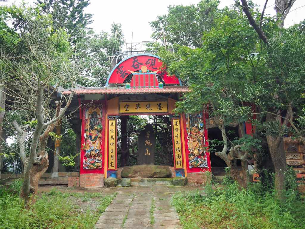
There were a few cars parked up by the trailhead, but signs asked visitors to head a little further down to Qudong Temple (曲洞宮) carpark, so we did. The temple had one of the most spectacular examples of topiary that I have ever seen.

The temple itself is a little less spectacular than it’s hedge-work, but I always like to take a little look inside temples when I’m passing.

From the temple you’ll need to walk back along the road to the trailhead, passing a large pomelo orchard as you go. An information board marks the start of the route, and the steps lead you onwards towards the top.

The steps are broad and shallow and it’s a very short and easy climb.

Right next to the top, the trail takes a sharp right turn and continues up another 20 or 30 metres to the summit.

As you near the top, take a moment to look back over the steps you’ve just climbed. The red-orange roof of Qudong Temple contrasting with the surrounding tree-clad hillside.

From the top, looking west, you can see out across Freeway No. 1 to the built-up area of central Miaoli. This image was taken looking a little more southish to where the red struts of Xindong Bridge stand tall above Huolong River.

The summit marker on the peak is tucked away right on the edge of the clearing and gives an alternative name for the hill, Mount Tuomin north peak (托皿山北峰). I think the confusion only exists for non-Mandarin speakers since it appears that both Chinese names refer to an ink stone (like an inkwell, but flatter with just a very shallow depression for the ink).

As I stood against the fencing to take in the view, an intriguing sight caught my eye a little further south along the top of the hill. Strange, colourful structures protruded from the greenery, part temple. I couldn’t tell what I was looking at, it seemed part phone mast, part pigeon loft. Naturally, my curiosity was piqued.

Taking a look at the map, it was clear that a trail cut along the hill top between the northern peak (where I was), to the main peak (where whatever this collection of buildings was). Returning a short way down the steps, I spotted the start of this connecting path diverting off from the main trail at a corner.

In contrast to the broad stairway, the hilltop trail is narrow, hemmed in by skinny stems of bamboo.

For the most part it was flat, but as I drew closer to the main peak, there were a few steps heading up.

And then suddenly I found myself…I’m not quite sure where…here…wherever here is. The trail ends next to a sign warning that you are entering private property and need to take responsibility for your own safety. Despite this, the trail is very well-trodden, indicating that plenty of walkers do indeed take their safety into their own hands.


Gathered around the main peak of Moyan Hill there is a kind of forgotten pleasure garden. No longer flowing fountains cascade into dry lakes, porcelain knick-knacks adorn the walls, and statues of mythical creatures jut out from the foliage. Equipment for fixing and finishing was scattered around as if the workers had just forgotten to come back one day.

From what I can glean from online information, this is the work of one family who spent decades working on what would ultimately be an unfinished project. But maybe it really is still under construction…slowly.

There’s actually a little photo of a family group pinned to the wall in one of the buildings. I think somebody must be maintaining the property, even if they’ve long since given up on completing it. The plants are overgrown, sure, but not nearly as much as you would expect if it were fully abadoned.

I had a fun time exploring the area (albeit a nervous one, keeping my eyes and ears open for any sign of guard dogs). This rickety stairway had been welded together out of what looked like random scraps, but was surprisingly sturdy.
This little clip was shot as I made my way back down from the viewing platform to the sheltered seating area below.

Exploring the site further led to more intriguing discoveries, like this tiny land god shrine (that appears to be one of those ones that you find beside a grave—except there was no grave) with a miniature temple on top of it. (There were three-quarters-burnt incense sticks in the little burner, so someone else had been by not too long ago.)

And the most prominent feature in the whole park—a towering dragon that may have once been part of a water feature.

Curiosity sated, I returned back the same way I had come, along the bamboo-lined path, then back down the steps. (Afterwards, I read that it is possible to follow a road down from the abandoned garden to the temple.)

When I arrived back, I found Teresa dozing in the car. (She wasn’t feeling well, but insisted that I needed to “do something,” so I was kicked out to go wandering.) I would have liked to have her with me though, I think she would have enjoyed the strangeness of this one.
How to get to Mount Moyan
Google Maps address: The trail starts from a rural road not far from Freeway No. 1. There is some roadside parking here, but signs ask visitors to park in the nearby Qudong Temple carpark.
GPS location: N24 33.605 E120 50.860
Public transport: Public transport doesn’t really run close enough to make it worthwhile. Your best bet would be to take a taxi there, then on the at back just keep walking towards civilisation until you can find a taxi to take you back.
Nearby trails:
Further reading: I couldn’t find any English information about this route, but you can see photos of the sunset and night view here, and this video has a few more shots of the garden:
Mount Moyan Trail Map
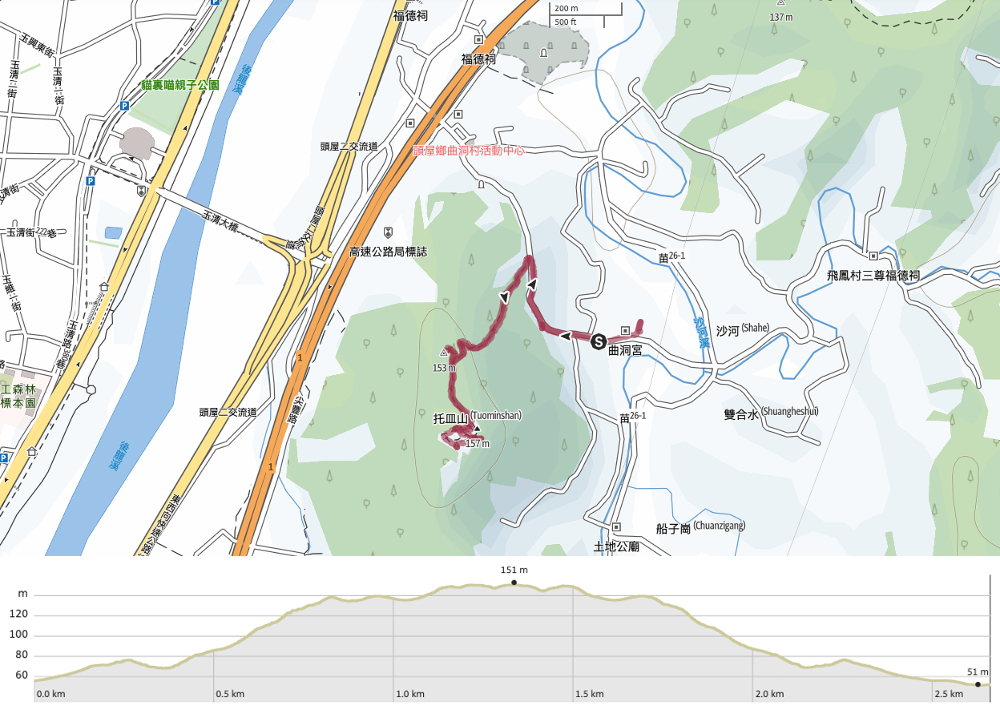
GPX file available here on Outdoor Active. (Account needed, but the free one works just fine.)
If you enjoy what I write and would like to help me pay for the cost of running this site or train tickets to the next trailhead, then feel free to throw a few dollars my way. You can find me on either PayPal or Buy Me a Coffee.
