
UPDATED: November 2024
Shuangliu National Forest Recreation Area is one of two forest parks to be located in Pintung County (the other is Kenting National Forest Recreation Area). The area gets its name for being the confluence where the two main tributaries of Fenggang River join – Shuangliu (雙流) means two rivers, and the sound of running water is a constant backdrop to the walk. Located on what was originally Paiwan hunting grounds, the park is now maintained by the Forestry Bureau, and has a more lightly managed feel than any of the other national recreation areas that I’ve visited.
There are four trails in the park to choose from: the waterfall trail (the easiest, we did this one because we arrived late and in poor weather), the Banyan Trail, the Mountainside Trail and Mount Maozi Trail (they missed a trick by not calling this Hat Hill). We’ll have to come back at some point to explore the other trails. It’s testament to the prettiness of the park that we had a great time despite never even making it as far as the waterfall itself. The trail is gentle, easy and has a couple of stepping stone trails that are great fun.
Distance: 5.7km – A smidge longer if you walk all the way to the waterfall.
Time: 1-2 hours depending on how slowly you take it.
Difficulty (regular Taiwan hiker): 0.5/10 – Not difficult in any sense.
Difficulty (new Taiwan hiker): 1/10 – Just be careful crossing the stepping stones in wet weather.
Total ascent: Almost none
Water: A single refillable bottle will suffice. There are water dispensers along the way.
Shade: Not too much shade, but it didn’t matter on this occasion.
Mobile network: I think my phone was without signal throughout.
Enjoyment: This is a lovely, gentle walk in beautiful surroundings. My only regret is that we didn’t spend very long here.
Other: There are multiple trails in the park, come in the morning and pick which ones you want to explore.
Permit: None needed, but you do need to buy a ticket. (See the bottom of the post for more details.)
Jump to the bottom of this post for a trail map and GPX file.

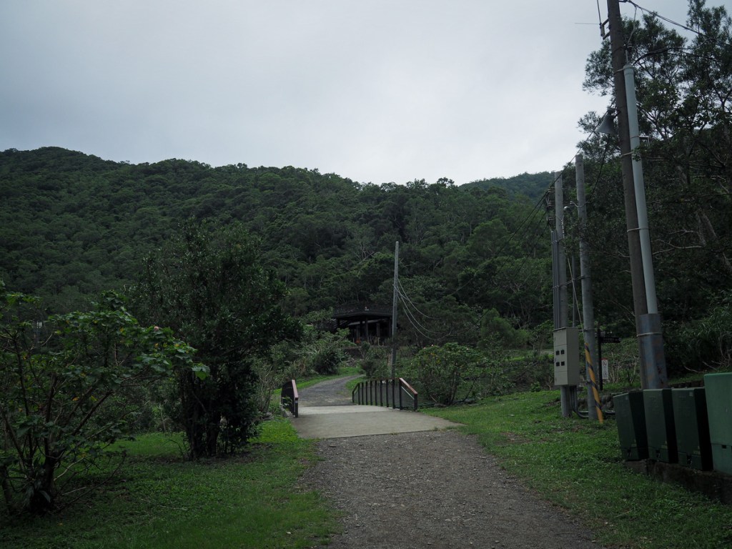
Three of the park’s four trails fan out from this spot at the rear of the carpark. The White Banyan Trail can be reached by heading left across the bridge towards the visitor centre, and the path leading to Mount Maozi starts its ascent from behind a pavilion on the right, but for the waterfall trail just follow the waterside track.

The trail and the river are fitted comfortably into folded hills, and when we went there was a low base layer of clouds sending wispy tendrils down to ruffle the tops of the trees. Cut off from even the sky, it feels a world away from…well, from anywhere.
Flowering hibiscus trees line the path (park authorities have labelled many of the plants of trees so that even botanical beginners like myself can enjoy the satisfaction of knowing what things are).

It seemed like everyone we passed was heading back in the direction of the carpark. Maybe the rain had chased them back to warmth, or maybe the park is just never busy on weekday afternoons.

At a left bend in the river, you’ll pass one of the entrances to the Mountainside Trail next to an open grassy area, and beyond that we passed an open-sided shelter where a few people were fiddling with their raincoats.

Close to the shelter, you can get a clear view of the river as it cascades down manmade waterfalls. A lot of rivers here have this type of defense work done to them to help prevent flooding, it’s not pretty but perhaps it’s better than the alternative.

Then we got to the really fun part, the river crossings. There are two of them with a gap of about 100m between them. I’d elected to wear flip-flops (not my usual hiking footwear, but we were planning to do a longer hike the next day and I didn’t want to get my boots wet), so I just waded in. The track is somewhat slippery though, but not so much that it’s unwalkable. I was expecting the water to be cold, given that the temperature was in the low twenties, but bizarrely it was very comfortable. Even more strangely, it felt ‘clean’, I don’t even really know what I mean when I say that, just that the quality of the water against my skin felt fresher than other water. (I mean clearly it’s full of fish poo and what have you, so maybe it’s all in my head.)
Between the first and second crossings, we passed the exit for the White Banyan Trail. It looked rather enticing, but sadly our time was too short.

Can you swim in Shuangliu National Park? According to signage at the site, no, but according to everything I’ve seen on other walkers’ blogs and on Instagram, it seems like quite a bit of extreme paddling occurs in the stretch of river between the two sets of stepping stones. In fact, there are even shower cubicles provided in the carpark’s toilet block, so I think as long is within this small area and you’re paddling rather than swimming, then it’s considered ok.

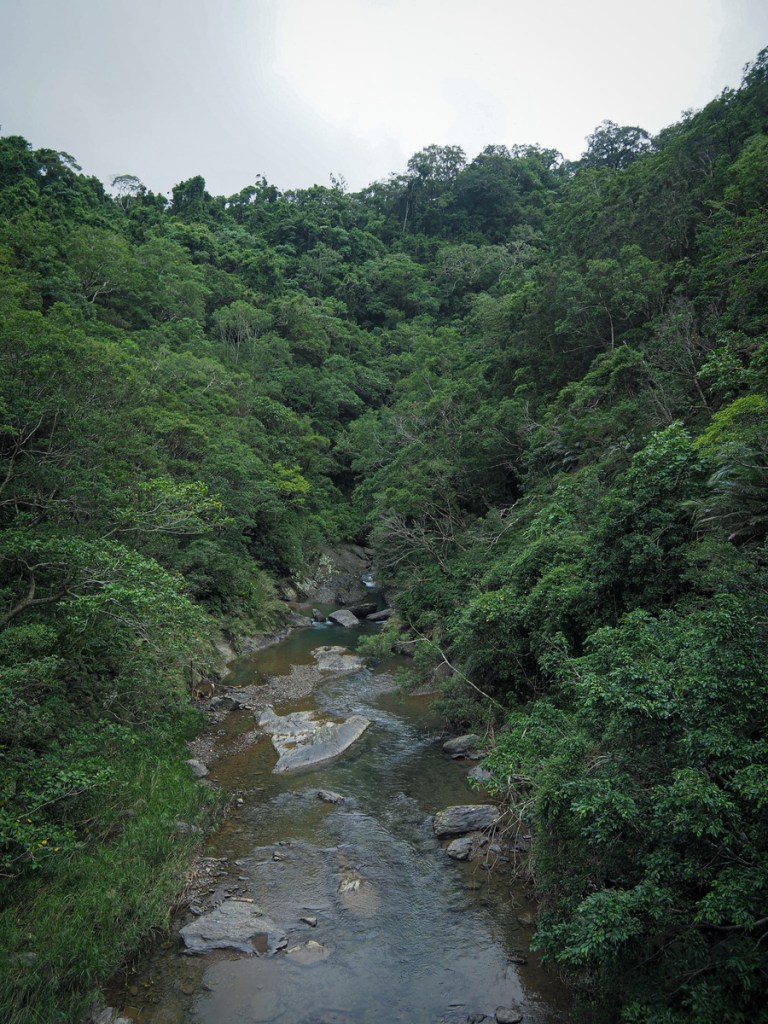
This is the view looking upstream from the second set of stepping stones. It feels unusual to find such a wide and peaceful watercourse in Taiwan, most of them are much more urgent and noisy.

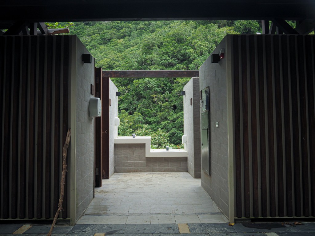
Continuing along the track, we soon found ourselves at a toilet block and rest area with a water dispenser and play park for kids. Here you’ll find the Mountainside Trail exit joining on the left.

The weather may have been dissuading others from entering the park, but my word did they have the wrong idea?! The combination of rain and diffuse, flat white light turned all of the leaves into works of art. The water and lighting picked out every line, every angle.

Despite visiting in autumn (mid-November), there were still quite a few flowers to enjoy – like this bedraggled Taiwan toadlily.

We visited just at the start of silvergrass season, so some of our river views were framed with delicate rain-beaded fronds of the stuff.
The first time we visited, we had to turn around at this point due to construction work, but the second time, the repairs to the waterfall trail had been completed and I was able to walk the whole thing. Just beyond the point at which we’d had to turn around last time, a sign on the right points up to the remains of an old charcoal kiln.
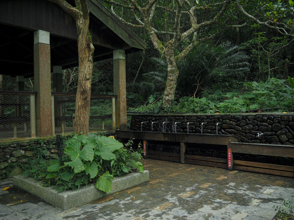
A little further on, the path arrives at a test area with a toilet block and a viewing platform, both of which overlook the river valley. A long trough-like water feature is fed by a creek above the pavilion, and was too inviting to ignore.
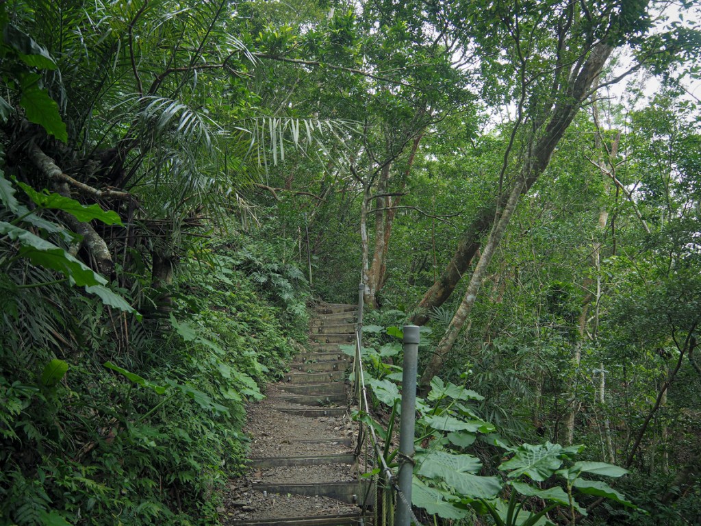
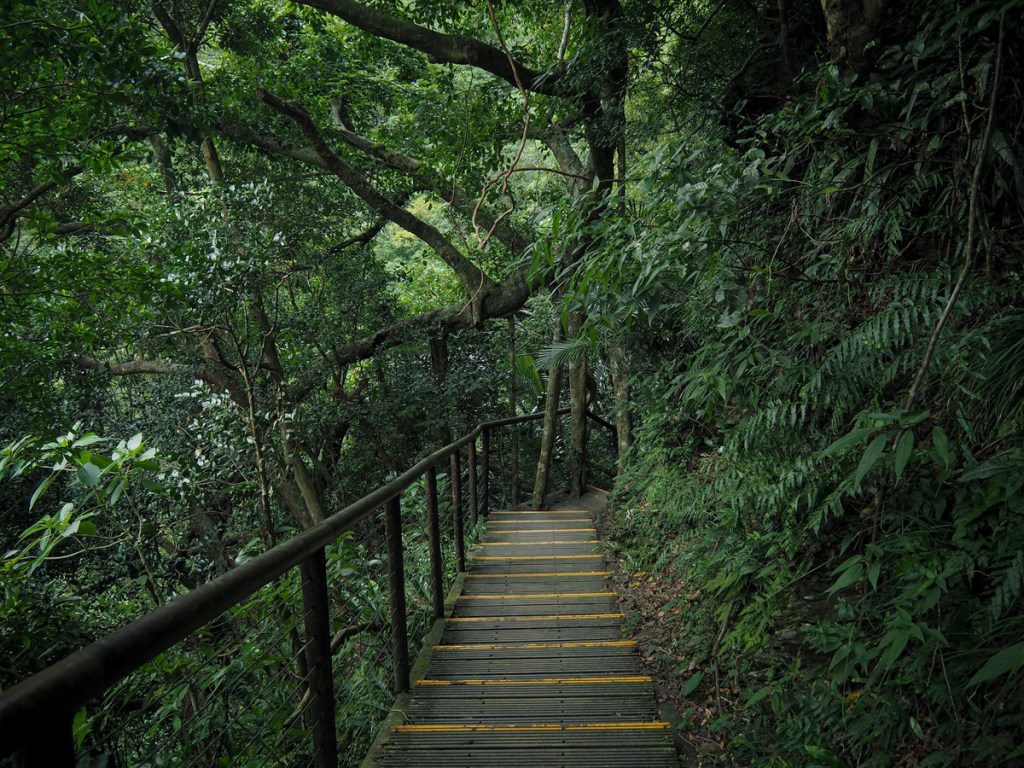
Beyond the rest area, the difficulty of the walk ramps up a notch or two. The flat trail transforms into a narrow dirt trail with steep steps.
After climbing for about 15 minutes, we found ourselves descending to reach the river valley once more. A bridge takes you over the water and from there, it’s just another couple of minutes to the waterfall viewing platform.
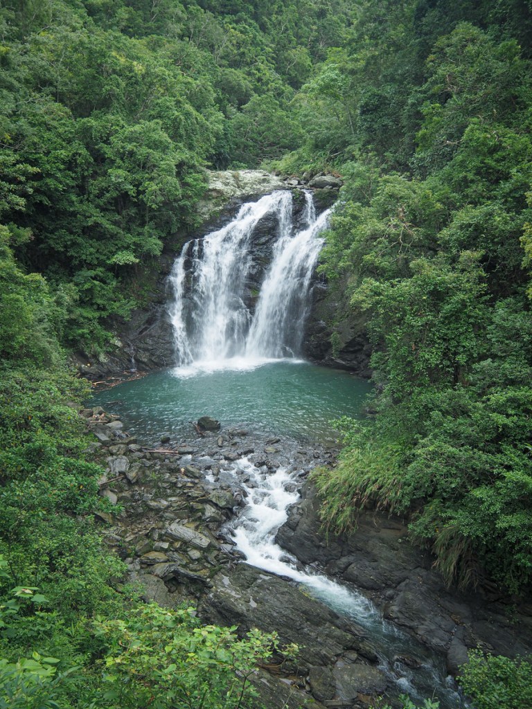
Shuangliu Waterfall has a kind of wonky fan shape, with the water tripping over the rocks at an odd angle before crashing into the blue plunge pool. Signs nearby state the that flow is pretty impressive year-round, but I suspect we saw it when it was slightly more powerful than usual on account of the fact that we visited at the end of a long wet summer for the south.
The waterfall is the end point of this walk, so once we were done soaking up the atmosphere, we turned around to head back to the park entrance. If you’ve still got time and energy for exploring, you could head back along the Mountainside Trail or Banyan Trail, both of which show different sides to this quiet park.

Walking back (on our first visit), we passed only five other people, a group of four soggy-looking visitors (Jehovahs Witnesses who asked if there was anything interesting further up the trail before handing us their JW business cards), and a woman who appeared to be a Forestry Bureau employee checking up on something. Aside from them, the park was empty and quiet.
Feeling unhurried and relaxed, we paid attention to all of the little details, and in doing so we were rewarded by discovering a whole host of life lurking in the pools beside the track. One area was full of tiny shrimp which darted into the swirling, muddy waters as soon as they saw us approach, nearby a colony of crabs was busy tending to their burrows, dragging rocks out and covering them with leaves. Elsewhere a lone crab scuttled through the leaf litter on its way to somewhere.

As we made it back to the rest area and toilet block, my attention was drawn by the pretty carpet of autumn leaves by the entrance to the Mountainside Trail. It’s quite a treat to see such a sight in Taiwan; mild winters mean that many trees remain green year-round. A few steps further, I looked up and saw the distinctive plumage of a male Swinhoe’s pheasant on the path ahead of me. It didn’t hang around to be photographed and chose instead to slink back into the undergrowth beside the trail.
Teresa managed to get over the first set of stepping stones, then halfway over the second before stopping…
…I think she had seen me wading through the water and decided she wanted a slice of the fun too.

We splashed around by ourselves like a pair of overgrown kids until we realised that the park would be closing very soon.
I’m glad we visited, but I definitely think this park deserves more time than we gave it, half a day at the very least, and more if you’d like to explore all of the trails it has to offer.
How to get to Shuangliu National Forest Recreation Area
Google Maps address: Shuangliu National Forest Recreation Area is located just off of National Freeway No. 9 in Pingtung’s Shizi Township. You can park up in the park’s carpark, just beyond the ticket booth.
Tickets: Entrance tickets can be bought from the ticket office at the entrance to the park. You need to stop here and get out to buy them:

Standard adult tickets cost $100 (as of 2022), with discounted tickets for children, seniors and students. It costs an extra $50-$100 to drive your vehicle into the park (depending on what type of vehicle it is).
GPS location: N22 13.045 E120 47.810
Public transport: Take the 1778 service from Fangliao Station and alight at Shuangliu. The Chinese directions on the park’s website suggest that as long as you let them know in advance, you can ask the bus driver to drop you off a little closer, by the FamilyMart at the entrance to the park’s road.
Further reading: You can read a little about the park here. (At least you can until the next time the government decides it needs to spend the budget on something, and so remakes the website again.)
SHUANGLIU WATERFALL TRAIL MAP
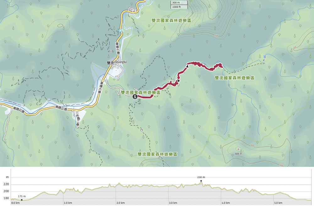
GPX file available here on Outdoor Active. (Account needed, but a free one works just fine.)
This is the bit where I come to you cap in hand. If you’ve got all the way down this page, then I can only assume that you’re actually interested in the stuff I write about. If this is the case and you feel inclined to chip in a few dollars for transport and time then I would appreciate it immensely. You can find me on either Ko-fi or Buy Me a Coffee.
