
RSA01
This first day on the Raknus Selu Trail (RST) is a looping wander which starts at Sankeng Old Street before heading down to the banks of the river that once made the area prosperous. Highlights include the very authentic-feeling old street, and a brick arch bridge with 100 years of history. We walked it as part of a three-day section hike over one of the coldest weekends of the year.
RAKNUS SELU STAMPS: There are two passport stamps that can be collected on this day’s walking. Somewhat confusingly, despite this section only covering RSA01, the two stamps that you can find are paired with RSA02 and RSA04. I guess sometimes it just works that way.
- RSA02: Located at Xiangheyuan Restaurant (祥和園餐館)
- RSA04 – Located at Shimen Bao’en Temple (石門報恩宮)
DISTANCE: 5.9 km – This doesn’t include the extra little bit of walking we did from the bus stop to arrive at Sankeng Old Street.
TIME: 2-3 hours. We were very slow walking this, mostly because we knew there was no hurry to be anywhere.
TOTAL ASCENT: about 80 metres.
DIFFICULTY (REGULAR TAIWAN HIKERS): 0.5/10 – This is a very easy walk.
DIFFICULTY (NEW HIKERS): 1/10 – Even for new walkers, this is very straightforward.
FOOD, DRINKS & PIT STOPS: A single bottle will be ample. There are some snack stalls at Sankeng Old Street, as well as several restaurants in the area. There are convenience stores and more restaurants close to where we stopped for the night.
TRAIL SURFACES: Roads, paved trails and bikeways, and one brief section of steps.
SHADE: Very little shade (it was peeing it down when we visited, so shade wasn’t much of a worry).
MOBILE NETWORK: Perfect coverage.
SOLO HIKE-ABILITY: This is very easy and safe to walk alone.
OTHER: Softer-soled shoes are advisable on this walk. And if you stay in the same hostel we stayed in, then remember to bring your own towel.
SECTIONS COVERED:
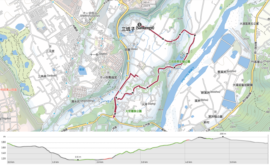
- RSA01 – Sankeng Old Street → Sankeng Eco Park → Daping Red Bridge → Linpi Historic Trail Trailhead (三坑老街→三坑自然生態公園→大坪紅橋→林埤古道口)
Jump to the bottom of this post for a trail map, GPX file and all the other practicalities.
DETAILS & DIRECTIONS:
A happy set of coincidences meant that I had almost three full days in a row without any work to do and (so I thought) my other half would be occupied with family stuff, so I quite impulsively decided to start my Raknus Selu Journey with a two-night jaunt from Taoyuan’s Longtan District through to Hsinchu’s Hengshan Township. In the end, my partner ended up deciding that she’d like to come with me, and luckily for her, both of the places I’d booked to stay had extra room.

14:37 – So it was, that we arrived at Sangkeng Old Street, the northern terminus of the Raknus Selu Trail on a very cold, very damp day. When I say cold, I really mean it (at least in the Taiwanese sense of the word). Forty-eight hours earlier, it had been a positively balmy 22°C, but on the day in question, the Mercury had plunged to about 10-12°C during the daytime and even dipped into single digits by the time we were walking back from dinner. Take the orange-tiled road leading down Sankeng’s Old Street.


Right at the start of the walk, we passed the first of what would end up being many traditional clothes washing pools along the RST. The very first of these I encountered was one between Aodi and Fulong along a stretch of the Tamsui-Kavalan Trails. Since then, I’ve developed a low-key obsession with them. Why? I couldn’t tell you. I just like them. This one’s distinguishing feature is the name it is known by: Heibaixi. Written in Chinese characters it is”黑白洗”, but when spoken in Taiwanese this is “o·-pe̍h sé” and means something like “washing in careless and disorderly fashion”.

14:41 – The further down the old street you walk, the closer you get to Longtan Yongfu Temple (龍潭永福宮), and the more lively the street becomes. Although calling it lively is probably a stretch. On the day we visited, only a smattering of stores were open, despite it being a Saturday. A friend who lives nearby said that no one visits on days as cold and wet as it was during our visit, but she also mentioned that since Covid, a lot of the businesses have either ceased trading or moved away.
Nowadays Sankeng is a sleepy rural backwater, but in days gone by, its proximity to Dahan River brought in many traders. From the 1740s, incomers began living in the area around present-day Longtan, but the numbers remained low until the early nineteenth century. Increasing numbers of residents meant increased agricultural production, and the nearby river’s deep currents made it easy to transport heavy loads by boat. Then in the 1860s, Erduanzi Port was constructed, making it even easier for the region’s tea farmers to ship their wares up to Tamsui and beyond. Over time, Sankeng grew into a prosperous Hakka settlement, but the village’s fortunes took a downturn after the construction of Shimen Reservoir and canal left the river with a much lower water level.


Once you hit the temple, take a right turn and follow the lane slightly downhill. At the next junction, cross over a culverted stream and then take a left onto Yongfu Road.

It was right about here that we spotted our first Raknus Selu hiking tags. They’re twinned blue and yellow tags, one of which has the trail’s name in English and the other in Chinese.

The trail sticks with this road for quite some distance. We passed fields of rice, a few old brick houses, and other weird-looking new-builds.


14:58 – Then as the road begins to slope downwards, the trees on the right disappear and you can see the landscape stretching out before you. Well, you would if the weather were better.

15:04 – A shelter on the left of the road has been built beside the rebuilt remains of an old ox-powered rice mill (called a “rice wheel” or “米輪” in Chinese according to the signage). During the period of Japanese occupation, the original mill was used to turn brown rice into white rice. When the site was renovated in 2017, locals were not best pleased with the authorities’ decision to create a replica using modern building methods, claiming that it caused the site to lose its sense of authenticity.


Almost opposite the rice mill, we spotted some RST signage directing us down a muddy track on the right. We walked about twenty metres down the track before deciding to turn back and take the road instead. It seems this section is still under construction. It runs parallel to the road though, so either way works.

Soon we found ourselves entering Sankeng Ecological Park (三坑自然生態公園). We paused for a while under the shelter of one of the park’s pavilions and to make use of their toilets. Sankeng Ecological Park is situated just a short distance away from the banks of Dahan River. In fact, it was right around here that Erduantan Wharf (二段潭渡船頭 ) was once located. This port was instrumental in the growth and development of the nearby area since it allowed for goods and people to flow freely in and out via the waterways.

15:24 – The lake was full during our visit, but even the aquatic birdlife present seemed chilled to the bone.


Once we had started to get too cold to sit around any longer, we set off again. The RST signage is faultlessly good up to this point. It feels like the trail organisers are learning bit by bit from each long trail built in Taiwan and getting better at it. From my experiences with the Taipei Grand Hike and the Tamsui-Kavalan Trails, each one has felt better planned than the last.

15:38 – At the far end of Sankeng Ecological Park, the RST picks up a bike path that runs alongside Datiekeng Stream.


The water was full and loud during our visit, and with the cold getting colder, I chose to keep my hands in my pockets instead of taking many photos. At the end of the bike trail, take a right, and head towards the pylon.

16:06 – Here you’ll encounter Daping Red Bridge (打平紅橋), which (you’ll be unsurprised to learn), got its name on account of the fact that it’s built using red bricks. Celebrating its hundredth year in 2023, the five-arched red brick and glutinous rice paste bridge was previously the main route in and out of Daping. If you think the style looks familiar, you’d be right. The archways are modeled on those you see in covered walkways along old streets.

Just as you draw level with the bridge, look out for the steps on the right. An RST sign affixed to the railings indicated that we needed to head up here.
As you climb, you can see riverside houses in a nearby settlement standing high above the rice paddies.

16:13 – At the top of the stairs, turn left and walk towards the 7-Eleven. The first of the RST passport stamps can be collected here at this restaurant on the left opposite the convenience store.


If I’m honest, I felt a little awkward walking in knowing that I wouldn’t be buying anything (it has a very meat-heavy menu), but I needn’t have worried. We were instantly welcomed in and directed to help ourselves to the stamp by one member of staff. An older guy, maybe the owner, showed us his full passport and excitedly said “Do you know the Japanese guy?!” We asked what Japanese guy, and were told that there was a Japanese man in there earlier with a trail passport and planning to walk the whole thing. After that, the man gave us a little updated information on two of the stamp locations that were different to the information we’d got and spoke enthusiastically about the beauty of several sections of trail further south.


16:31 – After about ten minutes we thanked him and said our goodbyes and made our way on towards Bao’en Temple to collect the third stamp. On the way, we passed another clothes-washing pool.

16:35 – The temple can be found just 500m further down the same road. It’s a little odd actually. This stamp is meant to be paired with section six of the RST, but in fact, it’s closer to sections one and two.


When we arrived at the temple, a woman sat behind the desk mimed a stamping motion at us while raising her eyes quizzically and then pointing at the stamp. There’s a table set up outside which looks like it probably houses the stamp in good weather, but since it was cold and wet, it had been taken inside instead. The temple aunty asked if we were warm and dry enough before suddenly saying “Do you know the Japanese guy?!” and telling us all about the strange Japanese guy who was walking the RST in cold, wet weather.
This temple is home to the Xiaocukeng Workstation (one of six workstations placed along the length of the Raknus Selu Trail). It’s run by the Taoyuan Sanjieye Cultural Association (桃園市三界爺文化發展協會), a non-profit group which is involved in raising the profile of the local culture and history.

After stamping the passport, we went to have a look inside the temple. “You should pray for better weather tomorrow,” said the aunty. The all-red colour scheme makes the interior of this temple pretty full on, and there are many little curious things in side chambers or occupying smaller altars. As always, I was drawn to Huye. Judging by his full plate of eggs, this one is getting fed very well.
As we made our way back out of the temple, the aunty hooked Teresa back into conversation, wanting to know what brand our jackets were, how they could keep us warm, how much they cost, and where to buy them. Teresa’s hands were grasped (to test her warmth), and she was made to sit down so that the aunty could photograph the label inside the coat.
Finally, we were able to leave, and wandered back in the same direction we’d come until we arrived at our home for the night. We stayed in Sankeng Lao Die (三坑老爹) – a bikers’ (and hikers’) hostel run by a retired soldier. He welcomed us in, started explaining the facilities, and then as soon as he realised we were walking the RST he said “Do you know the Japanese guy?!” Seriously, this man is a celebrity! He also mentioned that he’d had another woman staying with him the night before who was also walking it, and another three women a few days earlier. It seems that word is quietly spreading. After chit-chat, we were shown to our rooms and left to our own devices. Walking done, bed sorted, there was just one more task to attend to: food.


We decided to walk about 15 minutes back in the direction of Sankeng Old Street to dine at this vegetarian Hakka-style restaurant and it was a very good decision. We ordered gong bao cabbage, bamboo salad, braised chestnuts with (fake) chicken, and sesame oil mushroom soup. At $800 for the pair of us, it was definitely quite pricey, but the feeling of a warmly filled belly after a cold afternoon’s walking is priceless. Besides, it’s almost impossible to find vegetarian Hakka cuisine, so for that alone it was worth trying.

Hunger sated, we returned to our hostel and settled in for the night. The whole top floor is just women’s dorms, and although there was one other woman in the place, she was in her own room and we had ours to ourselves.
GETTING THERE
Public transport:
- Getting to Sankeng Old Street – From Taipei Bus Station, take the 1820 or 1820A Kuo-gang bound for Leofoo Village. Even though the bus station has ticket counters, you can just can just tap in with your easy card when you board. Ride it for about an hour and alight at Zhongzheng Road bus stop (we caught the bus from the fourth floor of the bus station, but Kuo-gang has gates on two floors, so you will need to double-check). Cross over the road and walk to Zhongzheng Beiling Road Intersection bus stop to catch the 5055 (Via Shanzaiding). Ride it as far as Sankeng bus stop and walk the remainder of the way to Sankeng Old Street. (The 5044 will also get you close, but you’ll have to get off at Huai’en Middle School and walk a little further.)
- Returning from the end of RSA01 – Take the 5051 from Xin Village Road back to Longtan and alight at Beiling Road Intersection bus stop. From there, walk a couple of minutes to Zhongzheng Road bus stop and catch the 1820 or 1820A back to Taipei Bus Station. Or, if the timing works, you can catch the 5050 from Xin Village Road to Zhongli Station and then from there you can take a train to Taipei.
Accommodation:
Staying in Sankeng – We spent the night at Sankeng Laodie, about a 20-minute walk from Sankeng Old Street, and only about five minutes away from the start of the next day’s walk.
- Name in Chinese: 三坑老爹
- Address: 325桃園市龍潭區永昌路51巷18弄18號
- Contact: 034115350
- Facebook: @skld.034115350
- Cost $600-700 per person
RAKNUS SELU DAY 1 TRAIL MAP
GPX file available here on Outdoor Active. (Account needed, but the free one works just fine.)
If you enjoy what I write and would like to help me pay for the cost of running this site or train tickets to the next trailhead, then feel free to throw a few dollars my way. You can find me on PayPal, Buy Me a Coffee or Ko-fi, (and if you’re curious about the difference between the three you can check my about page).
