
DISTANCE: In total I walked about 8km, but if you catch a bus from the train station instead of walking then it should be more like 5-6km. It depends on which route you choose to walk around the top.
TIME: I spent about 3 hours including the time it took to get to and from Da’jia Station. If you drive up to the peak, I guess you’ll want to allocate a maximum of 2 hours (unless you have children who want to play on the plat equipment).
TOTAL ASCENT: A little over 200 metres.
DIFFICULTY (REGULAR TAIWAN HIKERS): 0.5/10 – you have to move your legs a bit.
DIFFICULTY (NEW HIKERS): 1.5/10 – some elevation gain, signage is very unclear, but your on a great big flat-topped hill in the middle of a plain, so you can’t really get too lost.
SIGNAGE: There is signage, but it’s sporadic, sometimes bilingual, sometimes Chinese only, and the maps are a mostly a waste of board space.
FOOD AND WATER: I was fine with 0.5L on a cool late autumn day. I took snacks, but didn’t need them.
SHADE: Mostly unshaded, I had to resort to my umbrella even in winter.
MOBILE NETWORK: Clear throughout.
ENJOYMENT: If you don’t have children, perhaps you’ll want to save this one for a ‘I don’t know what to do’ day rather than making it your destination. However if you have kids, the park alone will make this a definite hit.
SOLO HIKE-ABILITY: Absolutely no problems at all.
OTHER: To make a full day of it, you may want to plan the trip so that you can also pay a visit to nearby Gaomei Wetlands.
Jump to the bottom of this post for a trail map, GPX file, and transportation informatio.
DIRECTIONS:

I’d caught the 8:13 Tze-chiang Limited Express from Taipei Main Station, and that got me to Dajia a little before 10:30. I made use of the station’s hot water machine and toilets before turning right out of the main exit onto Zhongshan Road.

The road curves a little to the left as it heads through a mix of commercial, industrial and residential properties. If you keep an eye on the signs above the road, you should spot a couple of these brown ones directing you towards Tiezhan Mountain Scenic Area. Just after you pass a petrol station on the right you need to turn right (still on Zhongshan Road).

The mix of buildings around here include agricultural as well as a few factories and houses.

I kept following Zhongshan Road all the way to this junction with Chenggong Road where I turned right and started to head uphill a bit. You’ll soon cross over the railway line which, much to my surprise, was just a single track. (Whilst on the train I had been aware of waiting at a station to let an oncoming train pass, and it had struck me as a little odd, but I hadn’t thought any deeper about it – now I know why.)

I kept following Zhongshan Road all the way to this junction with Chenggong Road where I turned right and started to head uphill a bit. You’ll soon cross over the railway line which, much to my surprise, was just a single track. Whilst on the train I had been aware of waiting at a station to let an oncoming train pass, and it had struck me as a little odd, but I hadn’t thought any deeper about it – now I know why. (It’s possible to cut out the above by taking a bus as far as this junction.)

Outside the temple archway there was a large collection of concrete guard lions just sitting in the shade of a banyan tree. I paused here to take off my jacket, and whilst I was doing that, a woman on a scooter rode up and parked in one of the spaces. The trail starts by following the track just to the right of the temple gates, and when I started walking, the scooter lady was right beside me. We struck up a conversation and she told me that she often comes here for a bit of exercise. As has frequently been the case this year, conversation turned to my homeland and questions about how Covid-19 could’ve have hit it so terribly.

The track became a trail, although it never lost that strange edge of civilisation feeling with lots of signs that it had seen previous development poking out from underneath shrubbery.

The track passes a couple of ponds, then reaches a junction in front of a pavilion. My new friend told me that the path splits in several directions here, but that they all lead upwards. (I would later come back to this point after having walked in a big loop.) She then made her own way up whilst I stopped to try and make sense of the animals.

For some reason, this little patch of the mountainside has been given over to aquatic life: a huge marlin, a leopard seal, a shark, crabs, a dolphin, and this recalcitrant walrus all had their own little concrete pedestals in the middle of what were probably meant to be pools. I think they were probably all fountains once upon a time, but now only the dolphin is left dribbling from its nose. I decided to take the outermost path leading up the hill behind the walrus.

If you visit between November and March (weather depending), you should be able to enjoy the sweet-smelling flowers of the Bauhinia blakeana trees that line the trail (also known as the Hong Kong orchid tree).

I ignored a path from the right and kept heading up towards a pavilion.

Beyond the pavilion I took a left through to an area beyond the mesh fence.

But first I had a look at the view from inside the shelter. You can see kind of back towards Dajia, as well as another nearby hill which houses a cemetery and what looks like some type of military structure.

Up here it appears that someone has tried to neaten the trail a bit, but it’s hardly pretty – hopfully in a few years the trees will have had time to grow a bit more.

From inside the fenced area you can see out towards the Taiwan Strait – just north of Dajia. I saw an express train speed along the rails past paddy fields full of egrets and over the bridge.

I followed the steps up back towards the fence again, and then through it for a second time. I passed one other person, but it seems this section of the hill is not as popular as the flatter top section.

At the top of the steps I headed past a concrete water tank, and then something caught my eye on the right.

From a distance, it looked like a giant snake twisting its way through the trees, but a closer look revealed it to be an empty pool or maybe a boating lake. The fact that the walls were so high above ground level made it kind of strange – in some places I could barely see over them.

From there I returned to the path I had been on and then kept heading a meandering straight towards the top of the hill.

You’ll know when you reach the busy area when you come across an awesome adventure playground. If I were still a child I would have been all over the equipment in a shot. There were rope tubes, a zip wire and rock climbing walls for small adventurers to scale – I later learnt that this was only a couple of months old at the time when I visited.


Note: when I revisited with Teresa at a later date, she did not hold back. In fact, I think there were more adults playing than kids.

I kept sticking to the leftmost outer path as I made a loop around the plateau.

There have obviously been efforts to turn this into ‘A Destination’, because in addition to the massive playground there are lots of sculptures and a visitor centre.

Despite this, I’m not quite sure that they hit the vibe they were going for – the visitor centre appears shut (it wasn’t), and the sculptures just seem to have been plonked arbitrarily in random places rather than fitting in with their surroundings. Again, perhaps it is just too new to judge – it may well grow into itself with time.
At least there is a good (albeit distant) view of Huoyan Shan, another of the 100 Minor Peaks and this area’s most popular trail.

A little closer you can see a patchwork of fields dotted with the occasional building, then the wide expanse of Da’an River separating Dajia from Rinan (日南).


The perceptive ones among you might have noticed that there is a drastic change in the weather between these photos and the ones before. That is because on my first visit to the area, I didn’t actually make it as far as the summit of Tiezhan Hill. The foggy photos are from a second expedition with Teresa. How the summit is accessed is a matter of some contention. The hiking community feels it’s one way, the land owner disagrees. Because of this, you’ll have to consider for yourself whether you want to include this part of the walk. (If you don’t it’s very easy to just walk downhill and skip this part.) Follow Taichung District Road away from the top of the plateau and past murals depicting themes of local life.

At the junction, take the unmarked track on the left. There are several hiking tags here that indicate where to go.


If you follow the road all the way to the top, it suddenly morphs into a dirt track. Turn right here and follow the track down past a farm. DO NOT GO INTO THE FARMYARD. Once you reach the farm buildings, follow the track to the right.

Immediately beyond the farm buildings, a faint path leads through the grass on the left. Once more, trail markers will indicate where to go.

This is where things start to get a little… vague. Beyond the tree, there are two trails. One goes straight and doubles back around the edge of the field. The other heads up a wall on the left and follows the track around the edge of the dairy farm enclosure. It seems from what has been written online that some hiking groups cut straight through the farm, setting off alarms, disturbing the cattle, and irritating the farm workers. If you do decide to visit this peak, make sure you are not one of those hikers.

If I’m being honest, the peak is pretty underwhelming (see above). In clear weather, you might have a view through the trees towards Fire Mountain, but no more of a view than from next to the visitor centre.


The only reason I can think of for really wanting to make the journey up here is to collect the digital gemstone given for climbing one of the Xiao Bai Yue.
From here, retrace your steps back to the road. You can either return to the visitor centre, or head downhill to see the sword well. For the purposes of making this post flow neatly, I am going to return from here to the visitor centre and pick up where my sunny day explorations left off.

Once you’re back on top of the plateau, follow the road straight until you come to a turn-off on the left. You will notice it because…

….there are yet more fascinating animal statutes. Here a pair of giraffes chew dangling chains – presumably there was something hanging from the signs previously.


By the giraffes I veered left with the road past a stretch of apartments that no longer had their front wall. I read somewhere that quite a few buildings here were rendered uninhabitable by the 921 earthquake – perhaps these are counted among their number.

The inside of each was the same, a large front room with a flight of stairs leading up to the second floor just in front of the small toilet. My favourite was this one with a beautifully tiled floor.
From there I followed the road a little further until I came across this nightmarish octopus.

Then I took the nearby path leading towards a house-high statue of Koxinga gazing out over a steep flight of steps, which I took before taking a left turn towards…

…more animals. Tigers this time. In my head, the standing one is the bore in the relationship, always boasting or blathering on about something or other, whilst the one lying down is the long suffering, silent partner, caught in the act of rolling its eyes.

Behind the tigers there is a memorial stone dedicated to Koxinga – one of the characters who looms large in Taiwan’s history in part due to his role in ousting the Dutch. What is his connection to here you ask? Good question. Koxinga died from malaria shortly after sending the Dutch forces packing, and almost certainly didn’t travel far beyond Tainan, but despite this there are a number of apocryphal stories of his heroic exploits scattered across the land. One such tale has him leading troops north towards Da’an Port (the place where the nearby river estuary joins the ocean), to battle the local aboriginal people. Unfamiliar with the landscape, Koxinga did what seems logical and headed for higher ground, somewhere that would grant them a tactical advantage.
Unfortunately however, what he hadn’t figured into the plan was how the summer heat and lack of water on top of the hill would combine to result in some deliriously thirsty soldiers. With the group besieged, Koxinga saw that the situation called for drastic action, and on Dragon Boat Festival, he threw a prayer out to the gods and plunged his sword into the earth. Much to the delight of all present, the celestial powers had heard their prayer, and sweet spring water sprang forth from the spot where the sword pierced the soil. The ensuing boost in the company’s morale gave them enough vigour to swiftly defeat their enemy.

As if in answer to that previous question, I returned towards the tigers, then passed a giant terrapin – clearly this peak got in due to its varied and wild decorations. The terrapin was accompanied by an emu, an ostrich, and a huge Guanyin statue.

I took the trail heading down next to the Guanyin statue, and found myself overlooking some outdoor sports courts. Steps led straight down onto the courts, so that’s where I went.

I wonder if you feel different knowing that your game is being adjudicated by a higher power; perhaps it deters cheating.


After crossing over to the far side of the courts I turned left, past the steps indicated by the yellow arrow, and followed the road past a military cemetery. At the far end of the carpark I took the steps heading down to a lovely temple with a tea urn and a cat that was hanging out with the Generals of the Five Camps.

Interestingly, one of the altars is given over t o Koxinga’s mum.

On my first visit to the area, this was as far as I got because the path down to the Sword Well was under construction. But this second time, it had been finished, so we were able to pop down for a look. The well is very shallow, but there’s water in it and a bucket for people to draw some up if the mood so strikes.
This well commemorates the (not entirely factual) story recounted earlier of Koxinga using his stone to draw water. The Sword Well as it is known, is now a popular destination on Dragon Boat Festival, when visitors queue to claim a bottle of the well water which is claimed to have restorative properties. The second echo can be heard in April, around the time when Qingming Festival (or Tomb Sweeping Festival) is observed. At this time, visitors to the area are able to see the spirits of the soldiers who perished in the battle, returning in the form of hawks, (the migratory Chinese Goshawk flies north around this time).
From here, we retraced our steps most of the way up…

…back up to the sports area, I took the steps indicated by the arrow on the right.

A small path runs down the side of the building.

Here I encountered a placid water buffalo standing in an unnaturally clear pool.

The path seemed to peter out, but then I realised that it just took a bit of a left turn before heading down these oddly diagonal steps, then down more steps through a crenelated wall.

Again I thought I’d hit a dead end, but then spotted these steps to my right.

Steps lead down through an area that looks like it would be perfect for picnics and barbecues if it weren’t for all of the “no barbecuing” notices everywhere.

There’s one final decorative flourish in the form of a dragon pond, and then the steps head right back down to the spot where my friend from the start of the walk left me.

The steps here bring you out right next to the giant marlin, and from there you just need to head back the same way. I decided to catch a bus back to the station from Tiezhanshan bus stop on Zhongshan Road, but despite this, I managed to get back to the town just after the vegetarian shops had all finished up their lunch hours and had to make do with convenience store fare before making my way over to the second spot on my day’s itinerary.
HOW TO GET THERE
Google Maps address: I started my walk from walk from the Yongxin Sports Park Hiking Trail entrance, but if you’re coming by car, it might make more sense to park up in the visitor centre car park.
GPS location:
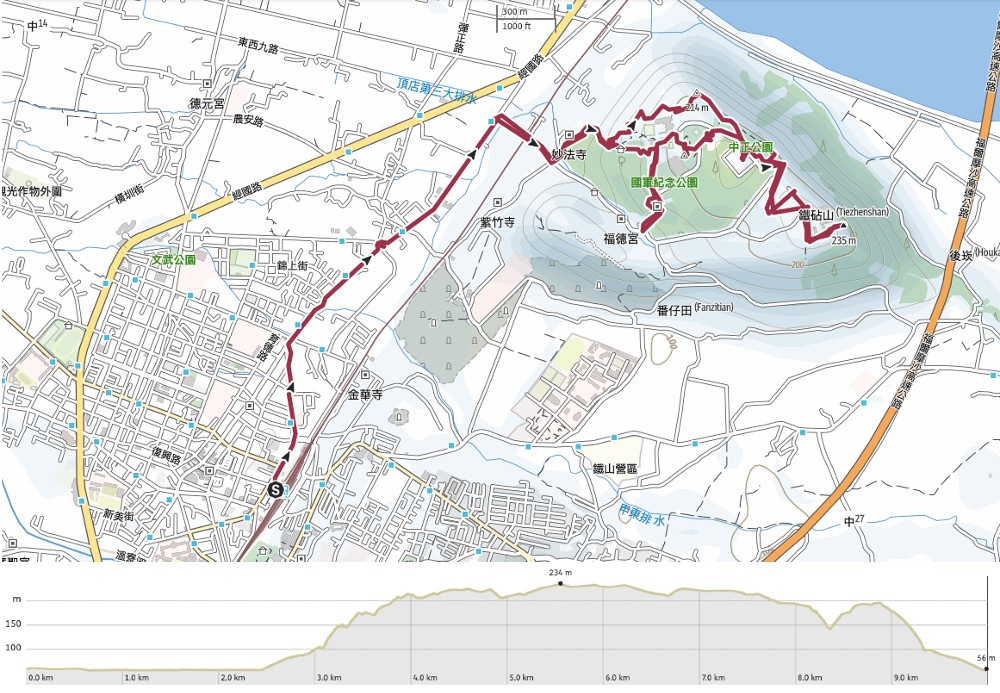
- Starting point for this walk – N24 21.570 E120 38.465
- Tiezhan Shan summit marker – N24 21.375 E120 39.305
Public transport: From Dajia Train Station, you can either walk the 30-40 minutes to the trailhead, or else take a bus. There are several buses which will take you most of the way there (the 93, the 181, and the 662). Ride them as far as the Tiezhanshan bus stop, then walk over the railway tracks to the start of the trail. To return, you’ll need to do the same in reverse.
Further reading: A news release about the opening of the new facilities.
TIEZHAN HILL TRAIL MAP
GPX file available here on Outdoor Active. (Account needed, but the free one works just fine.)
This is the bit where I come to you cap in hand. If you’ve got all the way down this page, then I can only assume that you’re actually interested in the stuff I write about. If this is the case and you feel inclined to chip in a few dollars for transport and time then I would appreciate it immensely. You can find me on either Ko-fi or Buy Me a Coffee.
