
Climbing Dugus A Du Lan – A Peak Sacred to the Amis Population in Taitung
For travellers to Taitung, climbing Mount Dulan – or Dugus A Du Lan in the language of the local Amis people – would make a wonderful day trip. The 1,190m peak sits close to the coast in Donghe Township, and on clear days visitors can enjoy views both of the ocean, and the East Rift Valley. However, even on days when visibility is low, the lush orchid and moss-filled trail has more than enough to make it a worthwhile trip. In cloudy weather, the forest becomes an enchanted wonderland, the kind of place where you could realistically expect to bump into a sprite or a talking deer. It’s little wonder that the mountain holds spiritual significance for the indigenous folks who live in this region of Taiwan.
DISTANCE: 7.9km – I have seen some people hike up the track from the road to the trailhead, that would pretty much double the distance.
TIME: 5½-6½ hours – It took us almost six hours with a shortish break.
TOTAL ASCENT: About 800 metres to a high point of 1190m on top of Mount Dulan.
DIFFICULTY (REGULAR TAIWAN HIKERS): 3-4/10 – The trail is quite steep, but it’s easy to follow.
DIFFICULTY (NEW HIKERS): 5-6/10 – Some steep scrambles over roots and rocks, there are ladders in a few places, but you rarely have to use your hands to climb, it’s mostly just very steep walking.
SIGNAGE: Exceedingly clear.
FOOD AND WATER: 1L was more than enough on a cool day, and we got by with a good breakfast and then taking some bread and nuts.
SHADE: Mostly well shaded, in fact, we were in the clouds for most of the walk, so we didn’t see a single ray of sun.
MOBILE NETWORK: Not too bad, just a bit patchy.
ENJOYMENT: This is a very beautiful patch of forest, the local climate means that it is lush and green year-round, with the chance to see lots of orchids and fascinating fungi if you go at the right time of year.
SOLO HIKE-ABILITY: I’d say this is ok to be walked solo, but only if you’re comfortable not seeing other people on the trail.
OTHER: Take at least a hiking pole, perhaps gloves as well. We had gloves with us, but we didn’t end up using them.
TAIWAN 100 MINOR PEAKS: No. 93
ROUTE TYPE: There and back.
PERMIT: None needed.
Jump to the bottom of this post for a trail map and GPX file.
DIRECTIONS:


09:08 – The weather wasn’t looking all too promising when we pulled up in the empty carpark at the start of the Mount Dulan Trail. There was a light drizzle that seemed to be threatening to tip over into rain at any moment. Looking up at the distant ridge line it wasn’t possible to make out Mount Dulan, the summit was shrouded in a loose cloak of cloud.

We set off up the trail, and for the first kilometre or so we were treated to a pleasant and comfortable climb. Very early on we passed the first of several small troops of monkeys, I don’t think there were more than a handful of individuals in any of the groups we saw. Each time we saw them there were one of two that were perturbed enough by our presence to bark at us, but they stayed high up and far away.

There are distance marker posts every 250m which somehow serve to make the distance feel even greater, particularly on the way up. As well as telling you how far you’ve come, each post lets you know which mobile networks have coverage at that location.

09:37 – Around the 1km mark there is a sign warning hikers that the trail beyond gets a little more slippery. It’s also right about here that we found ourselves climbing more steeply than before.

One of the great things about this walk is that the steeper it gets, the more scenic the route becomes, meaning that you’ve got a perfect built-in excuse to stop the whole time. The trees are draped with all manner of ferns, vines, orchids and fungi – each tiny area containing whole worlds of life.

10:03 – Where the trail climbs to join the ridge line, there is a scenic outlook which (theoretically) offers views out over Luye, but in our case, all we got were glimpses of farmland through the odd break in the clouds. (Scroll through the photos here to see what it looks like in clear weather.)

The environment here is very clearly one that benefits from frequent and extended periods of rainy weather, and there are no end of damp-loving flora on display. One of the more unusual examples that we saw were these delicate which strands of…something. After putting this photo online, it’s been suggested that they might be rhizomorphs of some type of mushroom. (I didn’t know what a rhizomorph is, evidently it is the underground portion of a fungus, something that’s not so commonly out in the open.)

Somewhat strangely, I never felt the trail was that steep on the way up. There was a constant climb, sure, but it felt fun rather than exhausting, do on the way down I was surprised to discover just how steep it had been. (Teresa seemed to have a rather different experience of it though.)

10:55 – We passed another group of monkeys and then we reached this stone altar. Mount Dulan is considered to be a sacred place by both the Puyuma and Amis tribes, and the altar is still used as a site of worship. When we passed by there were offering of rice wine and betel nuts left out on the flat stone.


Continuing on, the next 300m from the altar was relatively flat, but beyond that the path starts to get a little bit more up-and-down-y. Steps have been added to some of the trickier sections, but there were also plenty of muddy scrambles. There’s a steep downwards section which was the only part of the walk I found tiring when I had to climb it on the way back.

At one point the path cuts close to a towering cliff face which tilts out a little to provide some shelter. As we were passing by we heard a few more monkeys barks their displeasure at our being there, and I found a tiny leech on my finger trying to work out where the best place to get a meal would be. Thankfully I was able to flick it off before it got settled in.

12:01 – We made it to the summit in about three hours. The information board claims that the top of Mount Dulan offers expansive views of the coast and the east rift valley, but I think that must have been several years ago because it’s now very tightly hemmed in with trees. Besides, even if there had been expansive views, we wouldn’t have seen them through in this weather.


We didn’t stay long at the summit, without tree cover, the rain seemed crueler, and so we turned around and headed back to the overhanging rock we’d passed earlier. Here we sat down to have some snacks, and it was Teresa’s turn to make friends with the hungry leech (this was exactly the same spot where I met mine, so I like to think it was the same, but I guess that’s unlikely).

Walking down through the hazy, rain-soaked forest gave us more time to enjoy the magical scenery.


On the left there is supposedly a view of the coast, but all we had was an imposing wall of white. However it was hard to feel sad at missing out on the views when this is what we were seeing.

A branch dripping in moss. This is really the type of place you should see for yourself, photos can never replace the reality.


I stopped so frequently to take photos on the way down, that I often lost track of Teresa as she faded into the mists. Interestingly, the haze never felt oppressive or gloomy, the atmosphere remained light and comfortable despite the persistent fog.

Nearing the trail’s end, I spotted this bruiser of a tree frog chilling on an elephant ear leaf. iNaturalist suggests it’s probably a Moltrecht’s green tree frog – a species endemic to Taiwan.

14:47 – By the time we arrived back to the scooter, the weather lower down had started to clear up a little and from the trailhead pavilion we could see all the way out to the Pacific Ocean. A couple had set up camp on the pavilion’s upper deck, snacks and coffee supplies covering every bench and camp chairs set up so that they could put their feet up and watch the view. They were surprised to see people coming down from the mountain, expressing incredulity at the idea of starting a walk at 9am – I guess everyone has their own way to enjoy life.
HOW TO GET TO MOUNT DULAN
Google Maps address: You can find the trailhead here on Google Maps. There’s space for several cars and scooters in the carpark.
GPS location: N 22 52.350 E121 10.770
Public transport: You could get a bus from Taitung. The 8103 via Taitung Bridge and 8109 both leave Taitung Bus Station, pick up passengers from the train station and then head up this way along the coast, but… this would add an extra 3+ hours of walking (the track from the main road up to the trailhead is 4.2km in one direction). You’re much better off renting a scooter and coming here under your own steam. We rented one from 台東翔順機車出租 for the duration of our stay in Taitung. The store is very close to the train station, and we were happy with the scooter and service.
Further reading: I haven‘t found much of use in English, but there are plenty of Chinese posts out there. These guys went in great weather.
MOUNT DULAN TRAIL MAP
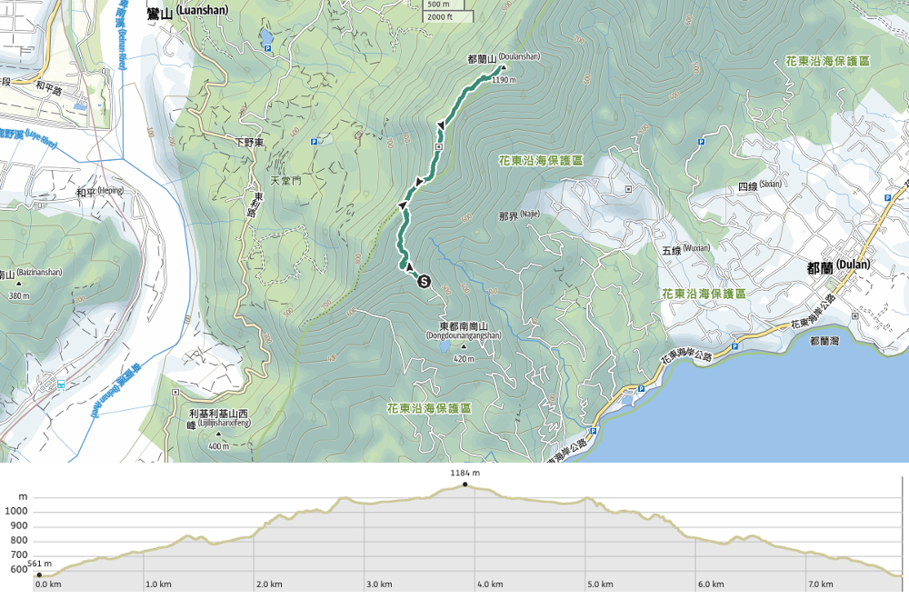
GPX file available here on Outdoor Active. (Account needed, but the free one works just fine.)
If you enjoy what I write and would like to help me pay for the cost of running this site or train tickets to the next trailhead, then feel free to throw a few dollars my way. You can find me on either PayPal or Buy Me a Coffee.

It is a beautiful part of Taiwan. I never know there were beautiful hiking trails like these in Keelung
LikeLiked by 1 person
Keelung does have some cool trails, but this one is actually much, much further down on the east coast, closer to Taitung.
LikeLike
For anyone trying this hike while using public transport, the hike from the bus station to trailhead took me 1:12h so no problem at all. Additionally there is the 8101 bus from the train station at 8:05 which works out perfectly with the bus going back at 15:31.
have fun 🙂
LikeLiked by 1 person
Thanks for a really helpful update! Glad you were able to enjoy this walk.
LikeLike