
Wugu to Linkou
(台北天際線第7B段:五股/林口)
This section of the TSLT picks up in Wugu and makes its way through some pleasant edge-of-the-city type trails as it skirts the northwestern edge of Taipei. Temple fans will also enjoy the large number and variety of temples to be enjoyed along the route.
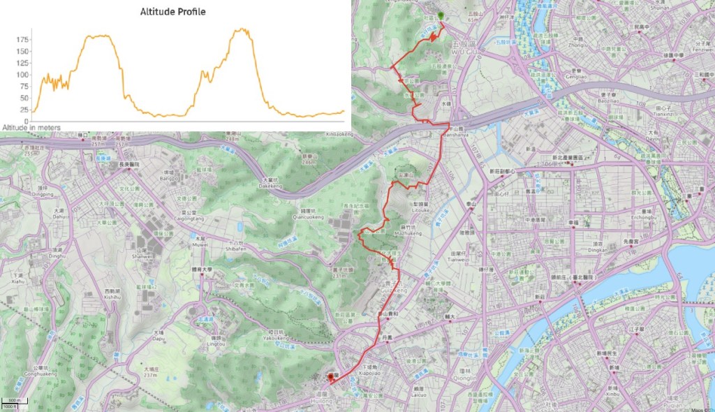
DISTANCE: 14.5km – this could be shortened in a couple of places.
TIME: I spent about 5¾ hours walking, I didn’t take any long breaks, but short ones.
TOTAL ASCENT: around 650 metres with descents of over 700m – with a high point of just 140-150m, that’s quite a lot of up and down.
DIFFICULTY (REGULAR TAIWAN HIKERS): 1.5/10 – Route finding presents a minor challenge; surfaces are uneven in places; easy, short climbs.
DIFFICULTY (NEW HIKERS): 3/10 – Being sure that I was going the right way would have been the biggest challenge for me early on in my Taiwan hiking career. Some climbing; a few sections of unsurfaced trail; distance is on the long side of reasonable.
SIGNAGE: Ok, as long as you know where you’re going and have a sharp eye. The on-trail junctions mostly have signage, but none of it is Taipei Skyline Trail (TSLT) specific, so it’s worth taking a map and/or downloading a GPX file of the route. Most junctions are also indicated by TSLT stickers or similar signifiers, but not all.
FOOD AND WATER: 1L of water and a few snacks should be ample you can top up at various places along the way. I got refills at a couple of temples.
SHADE: Not enough if it’s sunny – I used an umbrella for less shaded sections on a hazy but bright March day.
MOBILE NETWORK: Mostly clear, I noticed one or two spots where the reception wasn’t as clear, but otherwise, it was fine.
ENJOYMENT: This definitely isn’t the prettiest section of the whole trail, but there are always things to enjoy. The trails covered on this section are a good example of the everyday exercises walks taken by Taiwan’s fit retirees, and walking them will give you plenty of opportunities to chat to friendly pensioners (granted, that’s not everybody’s cup of tea, but occasionally I enjoy it). It also took me through a section of New Taipei City that I have little-to-no knowledge of – Wugu is normally just somewhere you fly over on your way from Taipei to the west coast. I enjoyed spotting the remains of old traditional houses interspersed amongst newer builds, as well as the many and varied murals painted on walls and shop fronts.
SOLO HIKE-ABILITY: This is very suitable for solo walking, in fact you’re unlikely to find yourself alone for too long.
TRAILS AND POINTS OF INTEREST ALONG THE WAY:
- Wugu Long-Feng Temple (五股龍鳳巖)
- Long-Feng Temple Footpath (龍鳳巖登山步道)
- Military Training Base (憲兵訓練中心靶場)
- Wugu Jiren Temple (五股濟仁宮)
- Shuidui Park (五股水碓觀景公園)
- Taishan Lower Temple (下泰山巖顯應祖師)
- Cixiu Park (辭修公園)
- Qiongzaihu Shan (瓊仔湖山)
- Qiongzaihu Fude Temple (瓊仔湖山福德宮)
- Shanding Park (山頂公園)
- Qitou Trail (崎頭步道)
- Yinghua Dapai Eco Park (應花大排生態園區)
- Upper Taishan Temple (頂泰山巖)
OPTIONS TO SPLIT THIS ROUTE:
- Wugu Long-Feng Temple to Shuidui Park – A couple of short sections of trail connected together.
- Cixiu Park to Upper Taishan Temple – This is the longest on-trail portion of this section of the TSLT.
- Taishan Temple to Huilong MRT Station – This part is all just road walking and not too exciting by itself.
Jump to the bottom of the post for a map and GPX file.
DIRECTIONS:
Numbers by photos refer to the GPS coordinates at the end of the post.

12:54 – I started off this leg of the journey by catching a bus to Wufu Community bus stop, exactly where I’d finished the previous section, and then picking up the walk from there. From the bus stop cross over these double roads and turn left down Minyi Road, Section 1.

Both sides of the road have been decorated with some colourful street art – here the wall below a land god temple is decked out with depictions of dragon dances. I went and had a look at the temple – a local grandma watched me checking out the photos of a thief pasted to one of the columns supporting the awning, apparently the guy had come and cleared out all of the offerings left for Tudi Gong on the deity’s birthday. I guess this type of thing explains why even the small temples all have CCTV cameras installed.

12:58 – Turn right up Lane 107. A brown sign hidden behind the mirror tells you that it’s the right direction for Long-Feng Temple Footpath (龍鳳巖登山步道), and a more prominent Chinese sign directs visitors to the temple.

13:05 – Longfeng Temple was constructed between 1977 and 1984, and is dedicated to Xianying Zushi Ye (顯應祖師爺) – a deity that I can’t really find much information about

A deity my sister would approve of – this horse just inside the dragon door is one of the temple’s incense recipients.

If you head to the back of the temple you’ll find the Longfeng Spring – according to local legend this spring (found with the help of ancestors) enabled construction to carry on despite the area experiencing a drought.

The main hall is closed to casual visitors, and whilst I was there I observed a master working with what I guessed to be a family group. (He’s just visible through the door to the right of the water dispenser.)

13:19 – Take the stairs on next to the temple sink. A map at the bottom of the flight shows how Longfeng Temple Trail connects Wailiao Road. (1)

The trail is one of those ugly concrete monstrosities that almost certainly started cracking as soon as it experienced its first earthquake. At this bend in the trail there is a small offshoot leading to a clearing atop a nameless peak – it seems that people probably come up here for morning exercise.

13:31 – The path reaches a T-junction next to a pavilion. Bear right and walk along a short section of raised ridge. The lefthand trail doesn’t appear on my map, but according to the map at the trailhead, it would seem to return to Longfeng Temple, coming out next to the toilet block.

Here the ugly concrete path becomes ugly concrete steps that are hemmed in by an ugly concrete wall – the green paint is presumably an attempt to lessen the ugliness. Signs posted at regular intervals indicate that the land beyond the wall belongs to CPC – Taiwan’s state-owned petroleum company. If you look on a satellite view map you can clearly see the vast tanks snuggled into the curve of the hill – they put me in mind of a giant spider’s eyes.

The trail soon veers away from CPC land and cuts through a patch of carefully tended-to allotments. There were few people around by the time I passed through – I have to assume that most of these small-scale farmers are early-risers.
In the middle of the allotments, there is a small temple ensconced within a tin shelter – this is Guanyin Temple (觀音堂). The yellow hoarding above the structure used to show its name, but the characters have long since faded into obscurity. The nearby area has obviously been used for many years – there are a whole load of messy, half-abandoned structures and a whole lot of mess.

Just beyond the allotments, there is an area of graveyards – some had already been tended to just ahead of this year’s Tomb Sweeping Festival, but others were looking distinctly unloved. Further on past the graves there was a more open bamboo farm – bamboo is one of the key agricultural products of Wugu, so these were just the first of many such patches of farmed land.

13:59 – The next surprise of the journey was these strange, initially pointless-seeming structures. A spiral staircase leads up a three-storey structure which looks like it has been designed to be just the facade of a building, nearby there are more similar structures. As I walked passed the first fake building I found myself being stared at by about 25 military-fatigue-clad men, and the buildings suddenly made a little more sense – the trail passes straight through a military training base. It seems that there might have previously been a fence separating the path from the army land, but that has long since collapsed, and now there is nothing. (2)

Keep to the path and head straight through the military training centre then turn left onto Wailiao Road. There are a few dwellings here, and perhaps a couple of companies too. One place has a load of sad birds stuck in cages, and another appears to be an office chair graveyard.

14:10 – The road comes to a T-junction and here you need to go straight over down a dusty little track, but first I went a few metres right to have a look at Jiren Temple (濟人宮).

I can’t find any information about Wugu Jiren Temple, but it is rather lovely in its own simple way. Incense-stained walls and aged polished concrete floors temper the opulence of the decorations in the way that you’ll see replicated in non-fussy smaller temples up and down the country. Faded rows of red plastic chairs contrast beautifully with the equally faded blue metal shutters outside, a notice pinned to the noticeboard warns against gossiping, and laminated photos show something engulfed in a blaze – it’s unclear if the two things are linked. A cave altar beneath the temple’s main deity houses Huye, and half-filled walls of blessing lights stand on either side of the room. (3)
As I was heading back to the junction I met a man who had passed me earlier. He was curious about where I had come from and where I was going, expressing slight concern at my chosen route, saying it wasn’t the easiest way.

14:21 – Follow the track all the way to its end here, ignoring a smaller trail on the right. I got a scare about halfway along the track when I looked up towards the private land on the left and spotted a massive caged Rottweiler dozing on the job. I’d walked about ten paces past it when the dog woke up and realised it had let an intruder sneak by – it then began alerting its owners (and anyone within about a 3km radius) to my presence. Those dogs are LOUD. Take the trail heading to the left of the fence through a whole load of clutter.

14:22 – At the far end of the fencing take a left turn down a much narrower trail. There are lots of tags tied to the fence which confused me at first, but you don’t need to go that way, I think they’re just tied there because that’s the most convenient location for them. (4)

14:24 – Just a couple of minutes later the path breaks out onto the top layer of Shuidui Park – clearly, my new friend from the junction has a different concept of difficult.

Shuidui Park is not my favourite Taipei Park, laid out over steep hillside, the planners have split it into ten flat, straightish paths connected by several steep flights of steps. Each level has a number indicating which it is on its northern extremity. A TSLT sticker on the number 10, and characters painted onto the tree tell you to walk south along this tenth level before taking the steps downhill at the far end.

From here it is just a case of heading more or less down the whole way. There are TSLT stickers placed at most junctions indicating where to go, but basically, you just need to go down, cross over a level and then go down the nearest steps.

One of the levels near the bottom of the park is actually a road, so make sure you check before crossing. The last level before the end of the park of this wooden decking. Keep heading over and then down towards the houses.

14:40 – When you reach the houses turn left and follow them to the road proper. (Actually, you might be able to head right too, but the track I was following went left.)

When you hit the road turn right and then immediately right again onto Shuidui 9th Road (水碓九路) so that you walk in front of the row of apartments that you just walked along the rear of. There are more TSLT stickers on the lampposts – many of them.

14:46 – Follow the road as it bends left then at the T-junction turn right onto Shuidui 5th Road.

14:47 – The apartment complex here is rather bluntly named ‘Big Apartment’ and there’s an adjoining coffee shop called ‘Good Neighbours’ which looks like it must have been named in the same meeting. At the end of Shuidui 5th Road take a left turn and head downhill on Denglin Road (登林路).

14:58 – The road bends left as it heads downhill, passing a basketball court and small temple on the right, as well as several convenience stores on the left. Here you need to stick on Denglin Road as it narrows to a single-lane and veers off towards the right. (Look out for the red cross and faux-red brick front of Wufu Fuyin Church.)

15:02 – Beyond the church, Denglin Road falls under the shadow of National Freeway No.1 – here you can choose to either take the footpath under the culvert or follow Denglin Road until it reaches Chengtai Road (成泰路). I was enticed to follow the latter route by the giant mural that has been painted all the way along the external wall of a large industrial complex.

The 140m-long artwork is the project of local politician, Song Ming-zong (宋明宗), in an effort to bring both aesthetic and economic benefits to the area by beautifying underused spaces. I’m not sure if it succeeded in the latter aim, but I certainly enjoyed the bright colours.
Bamboo features prominently in the imagery, as does the wildlife that you can find in the nearby river parks – I’m not sure how local birders must feel about the inclusion of the invasive sacred ibis, but the fiddler crabs and mudskippers are very cute.

15:08 – At the end of Denglin Road take a right turn onto Chengtai Road and pass under the multiple lanes of the freeway.

Follow Chengtai Road up to and then over Dake Bridge (大窠橋). I liked the tiny temple that was set into what looked like a modified bus stop on the northern end of the bridge. Once you’ve crossed over onto the far side, the road becomes Mingzhi Road (明志路), just keep heading straight along this for a little more than the next kilometre.
I stopped at a little corner shop selling scallion pancakes to get a snack to fuel the rest of my journey (extra cheese, no egg). The stall was quiet in the lull before schools let out so I had a chat with the proprietor whilst waiting for my food to be ready. She suggested that I visit Yinghua Dapai Ecological Park, a small public garden that had recently opened in the community. She said it had become popular in the past couple of months as a result of having many flowers in bloom. I thanked her, saying that although it wasn’t part of my plan for the day, I’d add it to my list of places to come back to, and then I went on my way.

15:41 – Look out for the Family Mart at the junction of Mingzhi and Cixiu Roads, then take a right turn onto the latter. The road runs past Taishan Senior High School before kind of terminating at a car/scooter park.

Sat in front of a toilet block at the rear end of the car park is a huge decommissioned airborne missile. In fact, the park doesn’t just have decommissioned weaponry, it also has a decommissioned tomb (ok, perhaps I’m stretching the definition of the word). Chen Cheng (陳誠), the Vice President who served under Chiang Kai-shek, was interred here from his death until the mid-1990s when his family decided to move him to a mausoleum in Kaohsiung. After his remains were moved, the land was turned into Cixiu Park by the local government, but the late Mr Chen remains in name – his courtesy name was Chen Tsyr-shiou (陳辭修 or Chen Ci-xiu in Hanyu Pinyin). (5)

15:48 – A grand, wide flight of steps cuts straight up the centre of the park, with more recently added wooden trails branching off on either side and lots of little pavilions tucked under the shelter of large trees.

Halfway up there is a large plaza that people were using as a badminton court and mini running track. The overall impact was both impressive and surprisingly pretty.
Midway between the plaza and the very top of the park I heard a woman’s voice coming from somewhere up above me. Confused, I glanced right and saw a couple of aerial arboreal adventurers – one earthbound, the other perched on a solid branch way up high. I went over to watch, the man on the ground acknowledging me and getting on with practising his throwline aim, the woman seemingly in her own world. Having done a spot of tree climbing myself last year I could entirely understand, there is something very hypnotic about sitting on a branch moving with it as the tree sways in the wind, getting all up close and personal with the world above the world.

15:57 – At the very top of the last flight of wide steps there is what looks like an outdoor stage, and perched on the steps at the front of it I passed a couple of grandpas who urged me to ‘rest a bit’ before carrying on. I told them I still had a ways to go and they urged me on my way. Turn left at the top of the steps and head for these much less grand steps that mark the start of Jiandong Shan Trail (尖凍山).

After the first few steps, the trail becomes a rougher naturally-surfaced trail. There is a brief climb followed by a right turn once the path levels out a bit.

16:04 – At the next junction the trail to Jiandong Shan continues straightish whilst the TSLT takes a left. Had I started a bit earlier I think I would have made a detour to the peak, but I’d started very late and it seemed like I might run out of daylight if I took too many diversions.

A tiny headstone just next to the trail.

Look out for steps leading down on the left, (straight on loops back up to Jiandong Shan).

16:09 – The steps let out onto the forecourt in front of a somewhat rough and ready temple (北台寶凰宮地母廟). I didn’t go in because there was a guy in the process of tending to the temple, but if you’re interested in culture you might want to drop in briefly – the main deity is Dimu Niang Niang (地母娘娘), a Taiwanese endemic (this word applies to gods too right) earth goddess.

16:11 – Take the steps leading down in front of the temple. (Signposted as going towards Chiungtzai Lake/瓊仔湖.)

16:12 – The steps let out onto a road just cross straight over and head up the steps on the far side.

In the bamboo fields that cover the slopes along the trail, I spotted a triangulation point – a sign attached to a tree marks it as being the north peak of Qiongzaihu Shan (瓊仔湖山北峰).

16:16 – The trail cuts down to cross an agricultural road, then climbs straight up on the far side again.

The woman in front of me was one of those barefooted walkers that you’ll sometimes encounter in Taiwan. She maintained a reasonable pace despite the lack of footwear, and stopped to make use of well-placed roots to massage the muscles in the arches of her feet.

I soon found myself passing the main peak of Qiongzaihu Shan, although at a mere 110m above sea level and with no real views, it didn’t seem all that significant.

16:28 – At the end of the trail I ended up back on what I assumed was the same road I’d crossed a few minutes earlier (it’s not the same at all). From here head through the red arch of Qiongzaihu Fude Temple (瓊仔湖福德宮).

Just outside the temple, there is an observation tower with a narrow and flimsy-looking spiral staircase. From the top, an observer has a slightly tree-obscured view northeastish over Taishan and Wugu.

16:31 – Looking in the other direction you can see where the trail continues – take the steps to the right of the gentleman in a white cap.

Before I took the steps I went to have a quick look at the temple and the view from its forecourt. It seems that this is a popular hangout place for local grandpas, and also a well-known night view location. A sign nearby says that the lake part of place name “Qiongzai Lake” is actually referring to the valley and that the first part is taken from another name for Chinese tallow trees. (6)

16:37 – Follow the steps up behind the temple and keep to the crest of the hill. Ignore the steps on the right here, and a little later ignore another flight of steps on the left.

16:45 – At the highest point along the trail I passed through Shanding Park (山頂公園) – a spectacularly well-equipped mountain gym full of muscular older fellows flexing their biceps and looking ridiculously fit. I was trying to photograph the general area without interrupting anyone’s workout, but this guy had other ideas – he wanted to be in the picture and who was I to turn down his request? (7)

Keep heading straight over and away from the gym, ignore the side trail on the left here, then further on ignore another side trail on the right.

16:51 – The trail emerges onto a road – this time it really was the same road that I’d been on earlier (just before Qiongzaihu Temple). You’re not on the road for long though, turn left down this track that’s signposted as going towards Tingtai Cliff (the English is a slightly erroneous translation of 頂泰山巖 – the name of the grand old temple at the foot of the trail).

There is a small dirt trail on the right almost immediately after you leave the larger road, but ignore that and keep heading down the track. There are a few scruffy looking buildings that may or may not be inhabited, and then the track abruptly becomes a footpath.

16:48 – There’s only a brief section of dirt path before it connects up with Qitou Trail, but before that, I passed these twin obelisk-style graves.

At the junction turn left onto Qitou Trail (崎頭步道) and start heading downhill for the final time on this part of the journey. Although it doesn’t particularly feel like it, this section of trail is at least a couple of hundred years old. Residents of settlements at the top of the hill would have used this path to travel to and from the city.

17:05 – There are two small temples on the way down Qitou Trail. The first is this one – Daqitou Fude Temple (大崎頭福德宮). There was no one here, so I took advantage of the quietness and the seats to have a rest, filling my cup with water from the water dispenser and enjoying the view south over Xinzhuang.

On my way to the next small temple, I ran into one of the most curious characters that I’ve met on my hiking journeys: Maxwell, or Maxie for short – a Ghanaian immigrant who has made Taiwan his long-term home (after some time spent living in north London). Maxie seems to be one of those people who just pulls people into his orbit because I found myself stopping to engage in conversation with him and his local companion despite the fact that I was being bitten all over.
Eventually, I felt like I had donated enough blood to the local mosquitos and so I bid them farewell and left with Maxie telling me to come back and become a regular face on the trail.

17:19 – The second temple on the descent has almost the same name as the first – this one is Qitou Fude Temple (崎頭福德宮). I remember this one having karaoke or salsa dancers and tea drinkers the first time I passed through, but that was a weekend, and on a Monday afternoon I had the place to myself.

17:29 – When I passed by this exuberantly flowering bougainvillaea I glanced to the left and noticed a little area next to the trail that had been prettified with flower beds. A second closer look and I spotted the name “應花大排生熊園區” – this was the place that the scallion pancake lady had suggested I visit.
Yinghua Dapai Ecological Park is a parcel of land with a stream running through it. Almost all of the information I can find about it online comes from 2021 or 2020 after the park suddenly gained online popularity, but there is one article which suggests that it has existed since 2009, prior to that it was a terraced farm (the land immediately above the garden still is). As I walked around I met a couple of people trying to tame another bougainvillaea plant that had grown over a path. The pair told me that the whole park was built with volunteer work.

17:37 – I returned to Qitou Trail and walked the final minute or so down to the end. (8) Before you get to the road you have to pass Upper Taishan Temple (頂泰山巖, the most commonly used English translation appears to be Taishan Up Temple, but since there is and ‘up’ and a ‘down’ I think ‘upper’ and ‘lower’ sound better).
As with most of the old temples you’ll find in the cities here, this one has a complicated backstory (it’s another one of those that makes me wish I had just walked on by and not stopped to try and under attend it). This one is even more complex than most – it had gone through a number of name changes, and there are actually two temples with names that honestly don’t seem to be too accurate. This story starts with the Li’s, a family of Fujianese immigrants from Anxi County. When they made the journey to Taiwan, they brought with them Xianying Zushi (顯應祖師, a tenth-century monk who got elevated to deity status in death). In 1754 they built a temple for their idol and called it Fushan Temple (福山巖). This building lasted for 99 years until fighting by rival factions of immigrants resulted in it being burnt down (this seems to be remarkably common in this period of Taiwan’s history). It was after the reconstruction that the name changed to Taishan Temple, and in the following years, the temple grew so popular that a second one was built nearby. Now with two Taishan Temples less than a kilometre apart, ‘Upper’ and ‘Lower’. Lower Taishan Temple (下泰山, often translated as Taishan Down Temple), is the newer one and can be found on Mingzhi Road (I actually passed it without stopping earlier on in my journey).
The current Upper Taishan Temple is a Japanese-era remodelling and is an example of the fine craftsmanship of Cheng Ying-bin (a much-celebrated temple carpenter of the early twentieth century). It’s definitely worth taking look inside, the use of more restrained aesthetic flourishes and the airy layout with walkways connecting around interior courtyards gives the temple a unique atmosphere.

With the temple at your back take a right turn and walk towards the archway at the entrance of Guizi Children’s Park. The archway is decked out with hanging toys that I think are meant to look cute, but at first glance, I found them somewhat spooky.

17:48 – The park itself looks great for kids, lots of play equipment and bright colours, but I got distracted by an old building, so I only walked partway through it.

Look out for a left turn down a narrow lane that runs alongside an old brick house. If you walk down this way you can catch a glimpse of the front end of a sanheyuan style house that seems to have been left to slowly crumble. (It also looks like nearby residents are charging park visitors a small fee to park on the land out front.)

Turn right onto Mingzhi Road (again), and then just keep following it.

18:07 – There are TSLT stickers even in the city, they’re just a little harder to spot. If you’ve had enough, you can shave off the final 30-minute road section and take a left turn under this raised road. You’ll soon come across Taishan Station (but that’s on the airport express line so expect prices to be a bit steeper than the regular MRT).

At the very furthest extent of Mingzhi Road turn right onto Zhongzheng Road. (Or if you want to stop early there is another get out here, turning left will take you to Danfeng Station.)

By this point, it was actual, proper dark and I was walking with the rush hour flow of traffic.

18:36 – I chose Huilong Station exit 2 as the ending point for my journey, in part because this is the one I would have to start the next section from, and in part because there was a promising-looking vegetarian shop right next to it. I inhaled a bowl of spicy coconuty noodles before catching the MTR back.
HOW TO GET THERE
Google Maps address: I started from Wufu Community bus stop and walked to Huilong MRT Station.
GPS location:
- Start of Long-Feng Temple footpath – N25 05.085 E121 25.915
- Long-Feng Trail exit – N25 04.770 E121 25.440
- Wugu Jiren Temple – N25 04.600 E121 25.520
- Entrance to the trail leading to Shuidui Park – N25 04.475 E121 25.635
- Entrance to Cixi Park – N25 03.440 E121 25.710
- Qiongzaihu Fude Temple trail head – N25 03.085 E121 25.370
- Dingshan Gym Park – N25 02.935 E121 25.190
- Upper Taishan Temple – N25 02.630 E121 25.420
Public transport:
- Several buses arrive at the Wufu Community bus stop – run between Luzhou Station and here, the 582 goes from Taipei Main Station or Ximen Station, and there are more from other places around the city.
- To return halfway through the walk, your best bet would be to hop on the airport MRT at Taishan Station (although it will be more expensive than the regular MRT).
- To return, you can either get on the airport MRT at Taishan Guihe Station, or keep walking to either Dafeng or Huilong MRT stations on the yellow line. I walked to Huilong so that I could meet up with my own footsteps when I started the next section.
Further reading: there are only Chinese language articles on this, these guys took a slightly different route to me, or at least went on a couple of detours. There are a couple of separate posts from this site which can be combined to make up the route I took. This post covers the part between the two Dingshan temples, whilst this one includes Shuidui Park.
TAIPEI SKYLINE TRAIL SECTION 7B – TRAIL MAP
GPX file available here on Outdoor Active. (Account needed, but a free one works just fine.)
This is the bit where I come to you cap in hand. If you’ve got all the way down this page, then I can only assume that you’re actually interested in the stuff I write about. If this is the case and you feel inclined to chip in a few dollars for transport and time then I would appreciate it immensely. You can find me on either Ko-fi or Buy Me a Coffee.
