
A Gentle Waterfall Hike in Nantou County
I feel like I don’t spend enough time away from Taipei, especially since every time I do leave for a while, I find myself really enjoying the experience. This was true for our trip to Puli. We didn’t really go with any plans, and most days we ended up choosing where to go the evening before. It was lovely. This little trail in Yuchi District turned out to be one of the unexpected gems of our stay in Puli. It has lush, fern-dense scenery and air cooled by the presence of nearby water. Exactly what you need on a hot day.
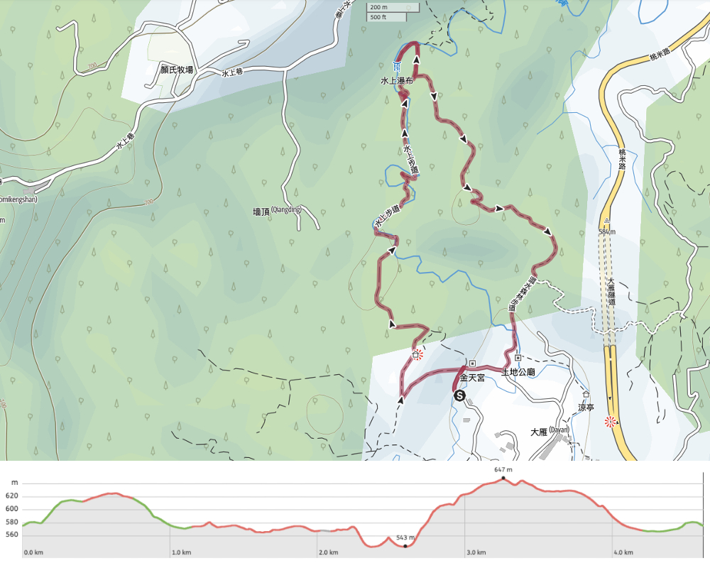
Distance: 4.6km
Time: A very gentle 3 hours.
Difficulty (regular Taiwan hiker): 2/10 for some slippery rocks and a bit of climbing.
Difficulty (new Taiwan hiker): 4/10 – Nothing too strenuous, but the uphill sections will feel tough if you’re not used to it. (We noticed quite a lot of Google Maps reviews describing it as being “really hard”.)
Total ascent: A little over 150 metres.
Water: We drank about 1L between the two of us.
Shade: Pretty well-shaded for the most part. However, I still used my umbrella for shade because my skin is that sun-shy.
Mobile network: Patchy, but it’s the kind of place where you’ll be glad if no one disturbs you.
Enjoyment: This is the perfect weekend afternoon walk. It’s pretty, a comfortable length, and beside the water.
Other: Take a towel so that you dry your feet off if the urge to have a paddle takes hold.
Route type: Loop
Permit: None needed.
Jump to the bottom of this post for a trail map and GPX file.

Jintian Temple (金天宮) marks both the start and end of Seshui Forest Trail. Housed in a well-maintained brick building, the temple’s main altar is given over to Xuanwu, with a couple of smaller altars on either side – although it was hard to make out who was there in the murk.


As well as saying hi to the gods, I was intrigued by piles of clutter heaped up in both wings of the main hall. There is just something very particular (and pleasing to my eye) about the quality of light that filters through into the interior spaces of temples here.
Another detail I enjoyed which seems specific to this temple is how every single animal depicted in the door and wall panel images had eyes that were exactly the same.

We filled up our water bottle’s from the temple’s water dispenser, wetted our towels from the sink, and then started up the road beside the toilet block.

The first part of the walk follows a single lane track up through scrubby forest then past tea farms before opening out to show you views of hills cloaked in betel nut plantations. At it’s highest point (just a little beyond Teresa), there is a trail on the left which takes you on a short diversion to a look out spot.


We followed the road as it started to lead downwards, and got ambushed by the residents of the last house who tried (very hard) to sell us tea. I tried to pretend I didn’t understand and instead tried to get their dog to pay me some attention. He is called Money.

The trail heads to the left of the last house and the road becomes a dirt track. There’s a landscaped area with a pool below the path to the left. It seems like this is the end of the walk for some people, but we were in search of a waterfall, so we kept going along the track.

Soon the track draws down almost level to the water, and we crossed the first of many bridges.

Even just being beside the water was cooling on a hot summer’s day.

The trail and the river criss-cross each other multiple times, each bridge affording you calming, watery views.

One bridge is guarded by a tyrannosaurus rex with fearsome-looking bamboo teeth and a pair of baby dinos. Somewhere I think I read a sign or some blurb about the trail which referred to is as “Jurassic Valley” and with all of the verdant plant life, I can see why. These dinosaurs fit right in.


Where it strays from the riverbank, the trail leads you through towering stems of bamboo and a seemingly uncountable variety of ferns.

In some places, the bamboo is thicker than your thigh. Ask me how I know this…
…I know this because we measured! Both of us taking turns to encircle the other’s thigh with two hands and then find a correspondingly large stem.

Just before the trail starts to climb away from the water there is a new-looking arched bridge. In some of the photos I’ve seen of this trail, it looks like there used to be a much lower log bridge.

From the bridge, we looked downstream and spotted a small group of people and their dogs playing in the water and decided to backtrack a little to see if we could dip our feet in the water.

Walking around a bend reveals a calm, shallow pool just before the water diverts through a narrow channel on its way to a lower pool. We quickly made friends with two of the three dogs, and I’m pretty sure we were in the presence of a Taiwan mountain celebrity. Unless I’m much mistaken, Petr Novotry was among the group enjoying the cooling water. For those who haven’t heard of him, the man is an insanely fit mountain runner who has made a name for himself during numerous (often dangerous) search-and-rescue missions involving missing and deceased hikers. Since I wasn’t 100% sure, it was him I didn’t want to intrude on some random guy’s happy family time, and we made do with fussing their very damp (very happy) dogs.

After a brief paddle, we returned to the arched bridge and crossed it to continue our journey. As soon as it leaves the water behind, the trail starts to climb steeply. The climb continues all the way to the waterfall junction. Unfortunately, Teresa is standing in front of the sign in the only photo I took of this spot. Affixed to the tree behind her is a hand-painted sign directing you down towards Shuishang Waterfall (水上瀑布). The sign also notes that if you do go down, then you’ll also have to come back up the same way.

There is a steep, muddy descent that’s a lot more slippery than any part of the trail so far, then it levels out to take you back upstream for a short way. When we visited much of Taiwan had been having heavy afternoon rains, so the ground was sodden. There are a couple of side trails here, but in each case, ignore them and stick to the most defined route.

The closer you get to the waterfall, the louder you get, and by the time we could see it we had to raise our voices to hold any kind of conversation. I was caught off-guard by the sheer size of the falls – in the photos I’d seen there had been people on the nearer rocks which made it seem smaller than it actually was, but looking at it with my own eyes I could see that it was at least as tall as our four-storey apartment building if not taller. The air here was noticeably cooler than elsewhere, a fine mist carried on the wind created by the plunging sheets of water.

We stayed a while enjoying a snack and the freshness of the air before returning up the same way. Going uphill a little slower gave me more time to appreciate all of the beautiful fern life thriving in the shade of the ravine.

Once back at the junction, we turned left to continue the loop. I can’t say I was thrilled to be going uphill again, but at least it was nice and shaded.


The track curves around the front of a farmhouse which looks like it might also have doubled up as a teashop at some point.


Once past the farmhouse, the track winds its way downhill through more tea and betel nut plantations – although these look a lot less cared for than those on the slopes we passed earlier. Keep an eye out for a signpost directing you down some steps to the right.

We’d been hearing distant thunder for a while, but as we made our way through the gap between these buildings we started to feel the first spots of rain.


Head over the bridge, then follow the water up towards the road. The grasses beside the trail here were dancing under the feet of lots of foraging birds – I spotted a whole flock of chestnut munias and a pair of collared finchbills.

At the end of the trail turn right onto the road then follow it up until you find yourself back at Jintian Temple. Almost as if by magic, we managed to arrive back at the car with literally seconds to spare before the heavens opened and we were treated to one of the heaviest downpours that I’ve seen in a long time.
How to get to Seshui Forest Trail and Shuishang Waterfall
Google Maps address: The trail starts in front of Jintian Temple. There’s roadside parking for cars and scooters, but no proper spaces. We visited at what I imagine was peak time for this particular trail, and found it pretty easy to get a spot.
GPS location: N23 55.385 E120 55.035
Public transport: You’re probably not going to go out of your way to travel here, but if you’re staying in Puli or by Sun Moon Lake, then this would make a good side trip.
- From Puli – Take the 6670D from Puli Station and alight at Dayan. From there it’s about a 20-25 minute walk to the temple where we started.
- From Sun Moon Lake – Take the 6670D or the 6668 from Shuishe Visitor Centre and alight at Dayan, then walk the remainder of the way.
Nearby trails:
- Mount Maolan
- Sun Moon Like Full Cycle Loop
Seshui Forest Trail Map
GPX file available here on Outdoor Active. (Account needed, but the free one works just fine.)
If you enjoy what I write and would like to help me pay for the cost of running this site or train tickets to the next trailhead, then feel free to throw a few dollars my way. You can find me on PayPal, Buy Me a Coffee or Ko-fi, (and if you’re curious about the difference between the three you can check my about page).

Thanks for sharing another great trail! We did this hike on a bit of a whim on Sunday after spending Saturday climbing Hehuanshan west peak and it was a great recovery hike and the perfect place to be in the hot weather we have been having. Unfortunately for us there was some sort of parent – child hiking event on so car loads of people were also enjoying the trail 😆
LikeLiked by 1 person
Oh no! That must have made the whole place somewhat less peaceful.
LikeLike