
On this particular Sunday, we were looking for something to get us out of the house but which would also require not so much effort. Maybe even something that was more about the journey to get there than the actual walking. And so it was that we found ourselves making a slow and leisurely scooter journey through quiet back roads towards Jinshan on the northeast coast. This trail was picked by Teresa on account of the fact that it doesn’t really include any steps (although, as we would soon find out, it does involve some very steep sections of farm track).
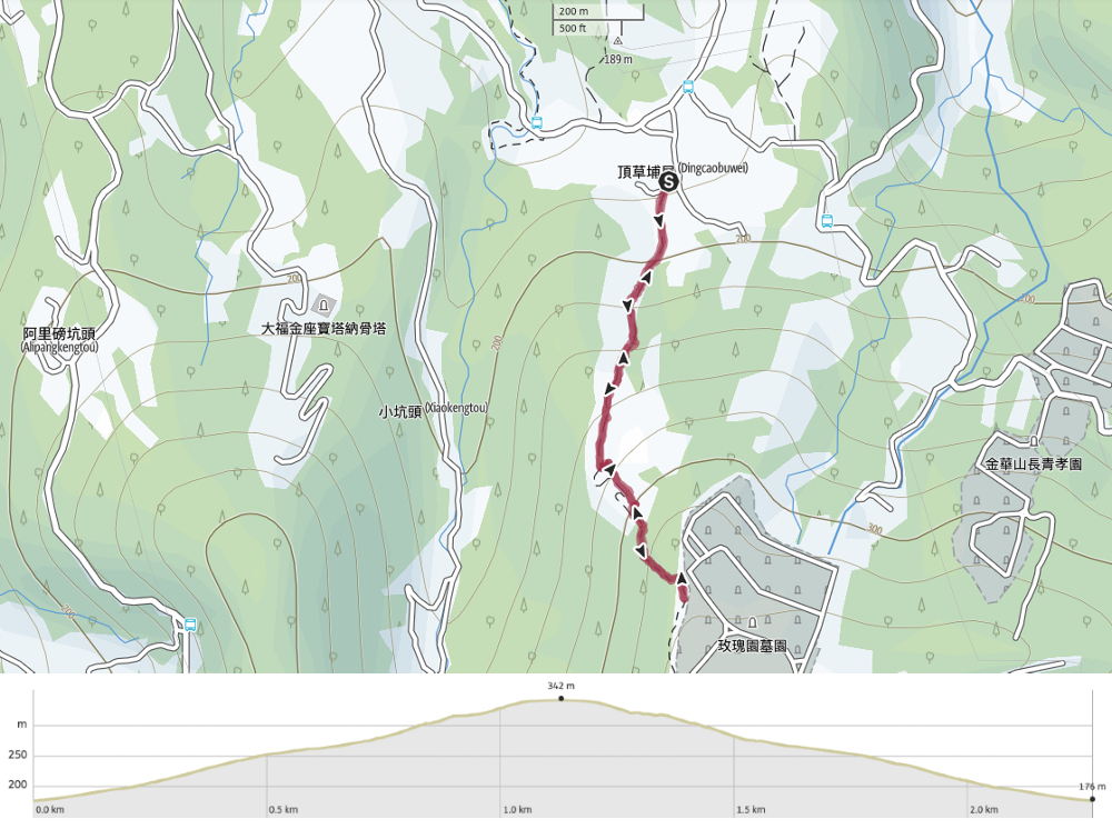
Distance: A little over 2km.
Time: It took us almost 2 hours, but that was because Teresa had recently had surgery and we were going slowly.
Difficulty (regular Taiwan hiker): 1/10 – The only difficulty is the steepness of the trail, but it’s most along a farming track so it’s very easy.
Difficulty (new Taiwan hiker): 3/10 – This is very steep, and quite out of the way, but it should be within most people’s limits with enough time.
Total ascent: About 150 metres.
Water: We took about a single 0.7L bottle between us and that was ample, even on a hot day.
Shade: Next to none, I was baking.
Mobile network: Clear throughout.
Enjoyment: It’s perhaps not the most thrilling trail out there, but you get to see tea being grown, and we saw a snake. Seeing a snake is always a good thing in my books… especially when it’s such a cute one.
Trail type: There and back.
Permit: None needed.
Jump to the bottom of this post for a trail map and GPX file.

We parked in an area that has been set aside for visitors to the trail, right next to a store that sells teas from the area. As we were parking, another family passed by, saw the car park and complained to each other about having parked so far away.

At the start of the trail there is an information board which states that the trail is roughly a kilometre in length, that there are around 300 types of tea in the world and a little about the trail’s management.

The first 200 metres or so is really quite steep, after which the trail levels off to become merely a more reasonable uphill as opposed to a silly uphill. I was questioning the judgement which had led to us picking this trail as a gentle stroll for someone whose legs weren’t functioning quite as well as usual…

Despite the impediment, Teresa still found time to do her favourite thing: spotting faces in leaves and then impersonating them. I think she did a pretty good job on this occasion.

The trail veers left then starts to climb more steeply again (do not be fooled by how flat this looks, it is not flat), climbing through a grand tunnel of towering bamboo. It looks like the bamboo is managed – or at least has been until recently – it’s starting to look a little scruffy though, so maybe it has been left to grow wild now.

Once we had passed through the bamboo tunnel, the trail opened out a bit, and after climbing a little further it was possible to turn back and get a glimpse of the sea.

A set of stairs on the left offers a shortcut/detour up to a viewing platform. Teresa found steps easier than a slope, so we took the steps and went to see what the viewing platform had to offer – not much as it transpired, there is a better view to be had slightly further up.

From the viewing platform, steps lead up to rejoin the road and before long we found ourselves taking a second shortcut.

Where this set of steps rejoin the road again, the track is flanked by tea plantations on both sides – I think this is probably the image which best illustrates how steep the trail is for pretty much its whole length).

There was only a brief section of farm track remaining before the track was replaced by steps. A sign here suggests that it’s a further 100 metres to the top, but I’m reasonably confident that this is an over-estimation.

The sun was pretty unrelenting, but at least it felt less humid than it is in the height of summer, dry heat is somehow easier to contend with.

Looking back towards where we’d come from the curved roof of a columbarium stood out, this one is 大福金坐, one of many such establishments gathered on the northern coast. And although hard to see in this image, it’s also possible to make out the four red and white wind turbines of Shimen Wind Power Station, (just to the left of the tall red and white pylon).

Right at the start of the stepped half of the trail, there is a small shelter and a tablet noting the benefactors who paid for the trail’s construction.

These two women had been sitting at the pavilion but hurried off when they saw us because one had forgotten to bring a mask. (At the time of walking and writing people in Taiwan were still required to mask up at all times when outside of the home.)

The steps climb up to a nondescript clearing with very little to see except for these hugging trees. (I forced Teresa into replicating their embrace with our fingers.)

Although the clearing itself is nothing to speak of, we spotted an overgrown trail leading through the shrubbery on the right.

The trail leads out to the edge of a lawn which belongs to Chin Pao San Cemetery – we watched a robot lawnmower zigzagging around on a distant slope dotted with huge abstract sculptures.

The only other thing of note here was a tiny little land god altar which seemed to have been buffeted by the wind. This is as far as the trail goes, so from here we just had to turn around and head back.

It was at this point that Teresa suddenly realised that going down was a lot less smooth than going up and that she probably should have brought two hiking poles with her.

The women had returned to the pavilion by the time we got back down again, and had resumed their lively conversation with the two gentlemen there.

We’d not gone more than a few metres beyond the pavilion when Teresa pulled me back up – I was so focused on helping her walk that I had all but stepped on this little beauty of a snake.
The ‘Y’ shaped pattern on its head identifies this as being a mock viper (these are considered mildly venomous). Once it had established that it wasn’t about to get crushed by my clumsy boots it continued calmly on its way.
Just where the steps rejoin the road there is perhaps the best view of the walk – looking to the left of the trail we saw the peak of Zhuzi Shan (竹子山) rising above tea terraces and clouds. This peak is further along the same ridge that’s home to Xiao Guanyin Shan.
It took us considerably longer than usual to get down to where we started, and as we made our way back to the coast on our scooter, we realised we probably should have stuck to the riverside trail instead of the mountain one – I guess that will have to wait for another day.
How to get there
Google maps address: The trail starts from a small collection of houses just off of 北21. You can find a small carpark here, and despite its small size, I doubt it is ever entirely full.
GPS location: N25 15.805 E121 36.150
Public transport: This spot is served by a little community bus, but there are only one or two buses a day, and I’m not sure it’s worth it.
Nearby trails:
Tea Mountain Trail Map
GPX file available here on Outdoor Active. (Account needed, but a free one works just fine.)
This is the bit where I come to you cap in hand. If you’ve got all the way down this page, then I can only assume that you’re actually interested in the stuff I write about. If this is the case and you feel inclined to chip in a few dollars for transport and time then I would appreciate it immensely. You can find me on either Ko-fi or Buy Me a Coffee.
