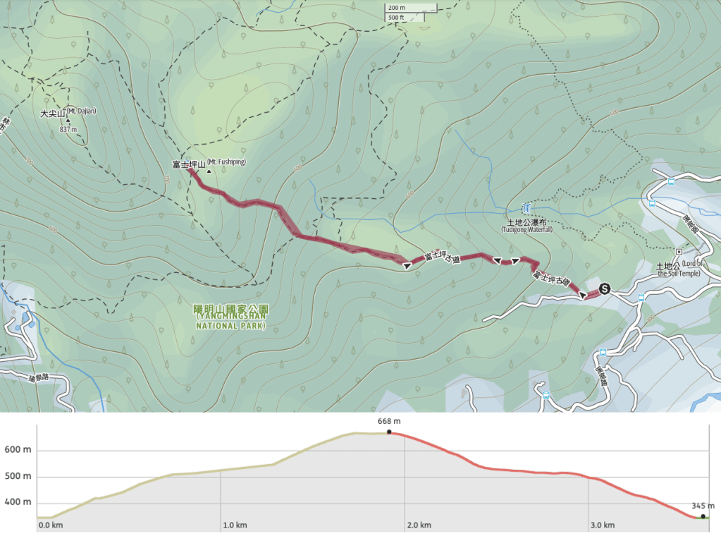
Distance: 3.7km – There’s definitely potential to do more here. You could easily make it into a loop, or if you apply to enter Mt. Huangzui Conservation Area then your options are even greater.
Time: 3-4 hours.
Difficulty (regular Taiwan hiker): 2/10 – steep start, muddy and rocky trail surface.
Difficulty (new Taiwan hiker): 4/10 – the walking is steep and slippery in places, it’s very quiet compared to other trails in Yangmingshan National Park, on-trail signage is Chinese only.
Total ascent: Around 320m.
Water: I was fine with 0.5L on a cool winter day, perhaps take a little more in the summer.
Shade: Pretty thoroughly shaded throughout.
Mobile network: A little patchy, but mostly ok.
Enjoyment: The quietness is a major bonus of this place, between the two of us we saw two muntjac deer and there is lots of bird life. I would have preferred to make this into a loop if we’d had more time, but we go a late start on this one.
Other: A hiking stick would be of use here.
Permit: None needed as long as you don’t go into the conservation area.
Jump to the bottom of this post for a trail map and GPX file.

Fushiping Historic Trail does not start in the most salubrious of locations. We parked beside an algae-covered pavilion and made our way towards the main gates of Fushiping Elementary School. Due to Taiwan’s declining birthrate and the urban shift of younger folk, the school had to close its doors a number of years back. It looks like it was put to use as an outdoor classroom/school adventure base for a while, but I’m not sure if that’s still the case. It looks a little bit too run down for that really.

There’s clearly still something going on here because a couple of greenhouse-y looking structures have sprouted from the crumbling playground, and someone is clearly feeding this elderly guard dog.

Behind their school there is an area given over to growing dragon fruit, the naturally sprawling vines having been coaxed into forming mop-like ‘trees’.

At the end of the dragon fruit orchard there is a fingerpost directing hikers off the track and onto a trail on the right.

As we were turning onto the trail, this farm dog bounded through the bamboo to defend its property. It gave off decidedly weird vibes, and it was hard to tell if it was overexcited or genuinely aggressive – one moment bouncing around with a relaxed wag in its tail, the next lunging, teeth bared. It is the only time I’ve seen Teresa resort to feigning attack to get a dog to back off, usually she can pacify any mutt.

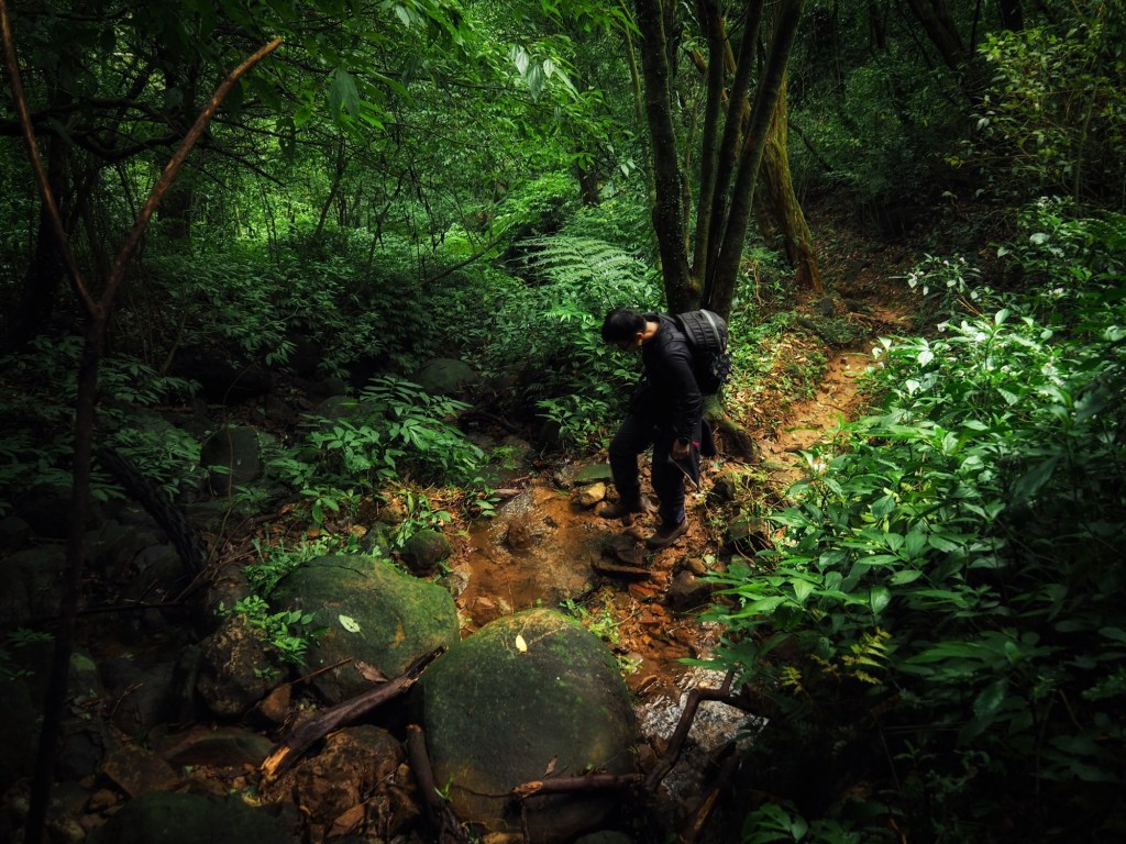
When it finally slunk back into the trees, we continued on our way up. The historic trail feel of the place comes through strongly, particularly right by the start. There are stone steps, lots of bamboo and hidden in the trees you can spot the remnants of returned-to-wild terraced farms. Whoever is farming the bamboo has strung up several items of clothing amongst the slender stalks of their patch – I don’t know what they are meant to deter, but they sure as hell look creepy.

It gets a bit steep in places, but the path was nice and clear.

A stunningly decaying leaf – there were several of them in the same area but I don’t know whether it’s caused by disease or some type of fungus.

After the very steep initial climb, the trail doesn’t exactly level out, but it does get a little easier.

Just before we arrived at this junction I spotted the flash of a white rump in the underbrush to my right, small pellets of deer poo confirmed my suspicion that I was in a muntjac’s territory. Head straight over here and continue heading up.

There’s another junction mere metres away from the first. Again head straight, ignoring the trail on the right.

Then within a minute or two there was a third trail branching off on the right. Once more we continued straight along the spine of the hill.

There is a very pleasant section where the trail is almost flat as it follows the ridge, then at a fourth junction we took the righthand fork. It’s signposted as heading towards Fushiping Grassland (富士坪大草原) and Dajian Shan (大尖山).

In a clearing right next to the junction is a humble Tudi Gong shrine. Inside the yellow-robed deity sits and watches over passing hikers. There were the remains of incense sticks, so people obviously do still pay their respects when passing through, but who packs incense along with the ten essentials?

The trail continues beyond Tudi Gong’s shrine, and from here the plant life and scenery change.

There are stands of cedars and the trail runs close to a brook, so the sounds of birdsong and insects are joined by the tinkle of running water. There’s also a heavy duty wall running alongside the left of the path for quite a way – likely left over from the Japanese era.

Where the tree line ends, there is a sign reminding walkers not to enter Mt. Huangzui Conservation Area without a permit, but (as far as I could ascertain prior to visiting), this area starts a little further in, just before the trail reaches Dajian Shan. Since we had no permit (nor time) to get to Dajian Shan, the plan was to walk about 100m into the grassland, just as far as Fushiping Pool.

There is rope pinned to the floor in the middle of the path, the purpose of this is to prevent hikers from getting lost in foggy conditions (common in the area, as is demonstrated here).

The pool is not a particularly noteworthy landmark, but it made as good a place as any to turn back and head home.

It’s worth coming up this far just for the stark contrast in the landscape that the meadow provides. On a sunny winter day this silvergrass must have a magical glow to it.
We took the same route back and the highlight of our return journey was that both of us got to see one muntjac each. I saw this noisy fellow standing on the path less than ten metres ahead of me, and Teresa saw one explode like a dart from a bush she had just passed. It was her first ever deer sighting.

When we returned back to the trailhead I was thankful that there was no sign of the white dog.
How to get to Fushiping Historic Trail
Google maps address: the trail starts from Daping Elementary School. There’s some space for scooters, but not much for cars.
GPS location: N25 09.365 E121 37.290
Public transport: There is public transport here, but not very convenient. The only service which runs here is the F922, a circular route operating from Wanli. But this only runs three times daily, and you’d have to get to Wanli first.
My new words learnt on this hike:
- 你很難取悅 / nǐ hěn nán qǔyuè / you’re hard to please
Fushiping Historic Trail Map
GPX file available here.
If you enjoy what I write and would like to help me pay for the cost of running this site or train tickets to the next trailhead, then feel free to throw a few dollars my way. You can find me on either Ko-fi or Buy Me a Coffee.
