
Alabao Bay is a short section of coast that can be found in Keelung’s Heping Island Park (和平島公園). When I first visited Heping Island with my other half, I noticed that there was a series of concrete posts straddling the inlet close to the temple with a statue of Guanyin. After taking a closer look at the signage, we saw that the coast further west of this point is open to visitors from May to late September when the risk of rogue waves is lower. It was duly stored in my pocket as something to do on a day when I wanted a gentle adventure. Flash forward a few months to early June. I’m busy with work, tired, and long for nothing more than to float in a body of calming water, so I head to Heping Island with my swimming gear and a sketch pad, having entirely forgotten about this trail. As a consequence, I ended up shouldering a full bag the whole way because I was too cheap to pay for one of the lockers (I totally could’ve stashed everything in the visitor centre). That aside, it was a great trip. If you don’t speak Chinese (and therefore don’t join one of the guided tours), if not sure it fully warrants the extra expense, but with a human on-hand to answer everyone’s questions, I was not sad to have parted with the extra cash.
Distance: About 2.3km (more including the walk from the bus stop).
Time: The guided tour takes 1½ hours, but if you’re doing the self-guided one, I’d say an hour would be enough. (You’ll also want to factor in more time for exploring the other sections of Heping Island Park and/or swimming.)
Difficulty (regular Taiwan hiker): 0.5/10 – Just some uneven surfaces.
Difficulty (new Taiwan hiker): 1/10 – If you can navigate to the park and figure out where to buy a ticket, then you’ve done the hardest part.
Total ascent: Almost none. My app recorded 45m, but that’s obviously inaccurate.
Water: A single refillable bottle will suffice. There are water dispensers both in the visitor centre and the temple just before you enter the restricted area.
Shade: No shade at all. I had suncream, an umbrella and arm covers, and still managed to turn a little pink anywhere my skin was exposed.
Mobile network: Clear throughout.
Enjoyment: I’m glad I went. It’s a pretty coastal area, and the added input from a local guide made it interesting.
When to visit Alabao Bay: Although most of Heping Island Park is open year-round, Alabao Bay is only open to visitors from May to September. The times that Alabao Bay will be open to visitors vary slightly from day to day depending on the tides.
Other: You’re not allowed to enter wearing sandals, so bring footwear that covers your whole foot (this only applies to the restricted area, not the rest of Heping Island Park). And if you want to go for a swim afterwards, make sure you’ve got your costume.
Route type: There-and-back.
Permit: None needed, but you do need to pay extra to enter this part of the park. (See below for full details.)
Jump to the bottom of this post for a trail map, GPX file, as well as information about transportation and tickets.

Tickets for the costal walk are purchased separately to the park entry tickets and need to be bought from the main desk inside the visitor centre (not at the front gate). You’ll be asked to write down your name and phone number and then given a ticket that you’ll need to exchange for your safety gear.


Head out through the visitor centre’s inland doors, then turn left to find the yellow shipping container that’s been repurposed as a safety equipment cabin. I gave my ticket to the man staffing it and he lifted me out with a stylish red hat and high-vis jacket, then told be to wait with all the other be-hatted people for our tour guide.

Our guide was an affable and funny older chap, whose name I instantly forgot because I panicked when he singled me out as the only foreigner for a personal greeting.


He took us on a slow and educational trip through the park, pointing out the different tree species and local landmarks.

We made it to the gated entrance to the coastal area and were let through by the gate guard.

Almost each and every one of the other visitors posed to have their photo taken in front of the zigzag bridge.

It is quite an impressive feature. And considering how solid it is, you’d hardly guess it’s only there for just half the year.

As we went, our guide pointed out some of the named rock features. I was drifting in and out of the reach of his voice, so I’m not sure if the land sloping down to the water here has been given a name, but if it’s not called the Drinking Dragon, then they’re missing a trick.

The path heads around the dragon’s head.

Looking across the water, you can just about make out a dark slit in the rocks. According to a signage in the park, this cave once sheltered Dutch settlers on the run from Koxinga’s northbound forces. Apparently, the fleeing Dutchmen carved messages into the soft stone walls, but if that were true, all traces of them have since been eroded by the passing of time.

Across the water, we had the narrow slit leading to Fanzi Cave (番子洞). Local legend says that words were once carved into the soft sandstone walls by Dutch settlers feeling from Koxinga’s army. The words have long since been erased by time and wind, but the story is remembered.

There were no wayward Dutchmen hiding out in the coastal caves during my visit, but there was a pair of very hot dogs making good use of a shaded overhang.

As we turned around the dragon’s head, we met a guard standing watch to make sure no walkers took the original concrete trail sticking close to the cliff. It had been damaged by rockfall, and is deemed at risk of further collocate.

Instead, it suddenly became clear why sandals are prohibited when we found ourselves walking on a walkway constructed of rocks encased in a wire cage.

Keelung Islet is visible on the horizon, as we’re the multiple tour boats plying the waters between it and Badouzi Harbour.


There’s much to look at on the shore. From the dramatic shapes carved by wind and water, to the fossilised remains of marine life protruding from the rock surface.

The walkway approaches another cliff with a distant guard poised with a whistle to urge forward anyone lingering too long.

At the far end of the cliff section, we regrouped and our guide asked a grew questions about what he’d told us. Correct guesses were rewarded with small prizes. (I got a mask for nothing more impressive than loitering at the back and being foreign.)

Actually, maybe I did deserve it for being singled out so many times, as in the case of this rock feature visible just beside a white pavilion. “It’s meant to resemble the face of a beautiful maiden,” said our guide, “just like our foreign friend here.” The freshly landed in Taiwan version of me would have died of embarrassment. This version of me just took my prize mask and smiled. The rock face (no pun intended) does indeed look like a pretty young lady, but unfortunately, it bears little resemblance to me.

I headed up to the pavilion to take a look at the tofu rocks. According to our guide, if you visit in September, you’ll be able to see it cloaked in vivid green algae. He also mentioned, that it’s possible for groups to book private sunrise viewing trips out to this spot if you fancy getting pretty sunrise shots. You just need to get a group of eight (or pay for a group of eight), and they’ll open up early for you.

After resting in the pavilion’s shade for a while, we turned around and made our own way back.


It was nice to go more at my own pace and pause to stop and look at the things that interested me. If I come again, I’ll do the self-guided tour instead of joining a group, but I think there’s merit to both. Especially if you speak enough Chinese to understand.

As I neared the end, I spotted a pair of men gathering seaweed from one of the tidal pools. If you walk around the villages in the area, it’s a common sight to see the stuff laid out to dry in open areas.

I made my way back to drop off my hat and vest, then headed over to the seaward side of the visitor centre to get changed for a dip in the ocean pool.
How to get to Heping Island Park
Google Maps address: If you’ve got you’re own mode of transport, you can navigate to the Heping Island Park Carpark. It should be possible for scooters to find street parking nearby, but if you’re in a car, you’ll probably have to pay the carpark fee.
GPS location: N25 09.630 E121 45.830
Public transport: The easiest way to access the park using public transport is to take a train to Keelung Station, then transfer to the T99 Taiwan Tourist Shuttle Shuttle Binhai Qiji Line bound for Shen’ao Fishing Harbour. The bus can be caught from Keelung Station (Visitor Information Centre) and departs roughly every 60-90 minutes.
Nearby trails:
- Bitoujiao
- Keelung Island
- Mount Gongziliao
- Mount Keelung
- Rongxuan Trail
- Shen’ao Rail Bike
- Wangyou Valley Trail
Alabao Bay Trail Map
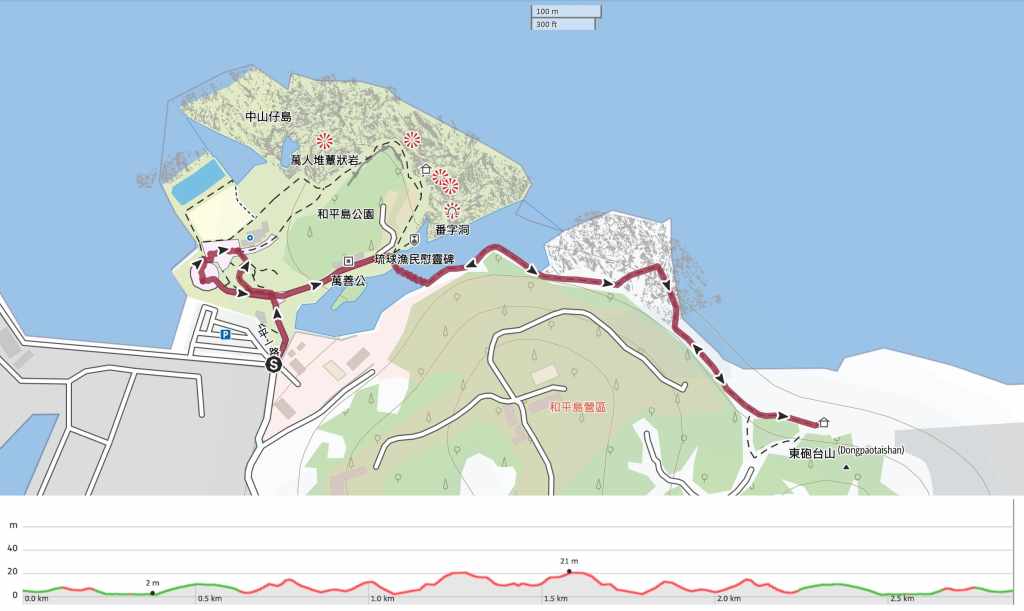
GPX file available here on Outdoor Active. (Account needed, but the free one works just fine.)
Come and say hi on social media:
If you enjoy what I write and would like to help me pay for the cost of running this site or train tickets to the next trailhead, then feel free to throw a few dollars my way. You can find me on either PayPal or Buy Me a Coffee.
