MSTW SECTIONS 31
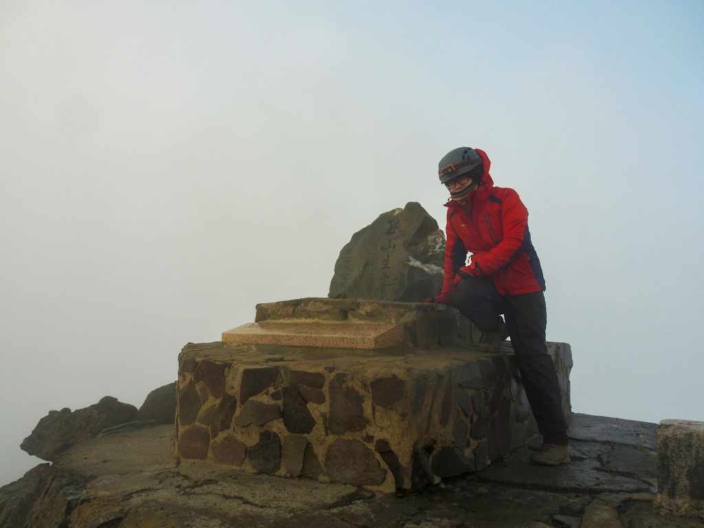
The final day of the MSTW saw us climb the final couple of kilometres to reach the highest point of Taiwan—the 3,952-metre summit of Jade Mountain. In contrast to the near-perfect weather that I’d had for the rest of the journey, we had thick clouds and raging winds awaiting us on the summit. Regardless, completing the journey was a quietly momentous occasion for me.
MSTW PASSPORT STAMPS: If you didn’t pick up the last stamp at Paiyun Mountaineering Centre, make sure you get it on the way down.
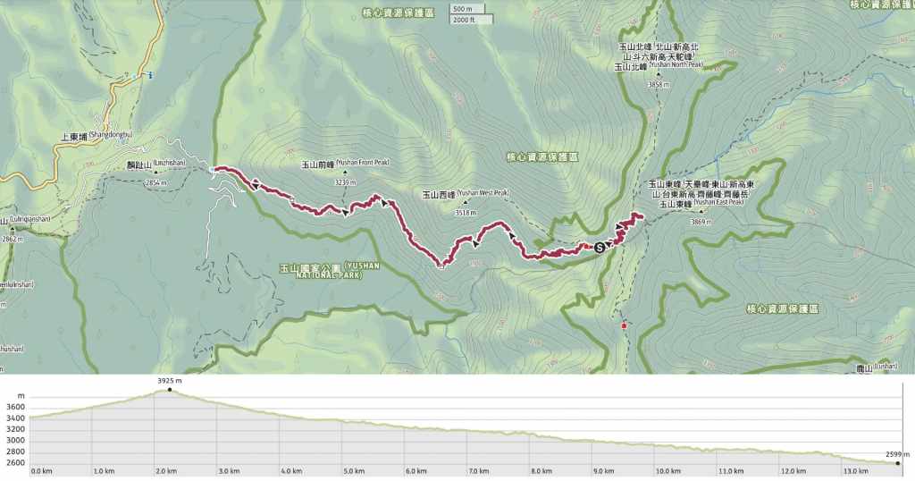
DISTANCE: 12.2 kilometeres. (A couple more kilometres if you choose to walk from Jade Mountain Trailhead to Paiyun Mountaineering Centre.)
TIME: Walking time is maybe only something like 7 or 8 hours, but the day is a long one. We woke up for 2 am breakfast and arrived back at Paiyun Mountaineering Centre at about 2 pm.
TOTAL ASCENT: About 700 metres… to the top of Taiwan! The 1,500-metre descent was far more significant.
DIFFICULTY CONSIDERATIONS: The majority of this route is relatively easy, with gradual ascent and wide, well-maintained paths. However, there are a couple of serious safety considerations that increase the difficulty level. The first is the elevation. Sleeping at over 3,000 metres is a little rough if you’re now used to it, and it’s very possible you’ll wake up with a headache, and that’s if you are even able to sleep—the discomfort and proximity of other hikers means you’ll likely also be contending with exhaustion. The altitude also means that the walking is more taxing than it would be at lower levels. Finally, the last 200-300 metres to the summit is exposed, steep and rocky with a real risk of falling—if you walk it in the dark, in windy and wet conditions (as we did), it requires caution.
FOOD, DRINKS & PIT STOPS: There is hot water available at Paiyun Lodge. Foodwise, you can arrange (in advance) to have breakfast and brunch provided at Paiyun Lodge. There are no places to buy food though, so you’ll need to have brought all other food with you.
TRAIL SURFACES: A mixture of dirt and gravel trails plus a few wooden walkways.
SHADE: Much of this trail is quite exposed and because of the altitude, you’re likely to feel the effects of UV rays more acutely. Proper sun protection (long sleeves, gloves, hat, sunscreen) is very important.
MOBILE NETWORK: Pretty clear throughout.
SOLO HIKE-ABILITY: The trail between Jade Mountain Trailhead and Paiyun Lodge is very easy to follow and not too challenging, but the risk of landslides and altitude-related illness means that it is a good idea to have someone with you.
OTHER: You must have secured both a National Park Permit and a Mountain Entry Permit before embarking on this part of the walk. It is also a good idea to have altitude sickness medicine. Even though I’d ascended as gradually as possible, sleeping at that elevation left me with a headache.
Jump to the bottom of this post for a trail map, GPX file and all the other practicalities.
DETAILS & DIRECTIONS:

We had chosen to have the 2 o’clock breakfast option (there’s a second service at 2:30 and we definitely could have waited for that one), but it seemed like the vast majority of the hikers in the lodge were getting up anyway, so I doubt we’d have been able to sleep in anyway. After handing over our tickets, we were given a plate and a bowl each and helped ourselves to bowls of watery congee, pickles, and steamed buns. If I were coming again, I think I would definitely skip the breakfast option beacuse this really wasn’t the type of comfort I wanted on a cold evening having just lain on a wooden board without really sleeping for six hours.

Teresa lacing up her boots in preparation for the ascent. We started off wearing our coats, hats and helmets, but no gloves.


3:08 – Stupified from lack of sleep, it took us over an hour from waking to leaving the lodge, but as it transpired, we were still probably about an hour earlier than we needed to be.

3:38 – There are only two junctions along the path between Paiyun Lodge and the summit of Jade Mountain, both of which are clearly signposted. Take the left here.

The first part of the climb takes you through more forest, but for the remainder, the trail zigzags up through exposed scree slopes.

The further up we went, the worst the weather seemed to become. It went from being a clear sky with visible clouds to being a billowing white veil. Looking ahead or back down the trail, I could see people’s head torches carving sweeping columns through the thick air.


4:45 – We made it to the tunnel and paused to put on our gloves. Looking up at the bar and mesh roof of the tunnel showed exactly why it is necessary—it is littered with rocks in varying degrees of lethality. In fact, after hearing the advice of a nearby guide, we decided to stop here and shelter out of the wind. She was telling her group that it’s another 400 metres or 30 minutes to the more exposed summit. The Japanese group we met with the day before also caught up with us here and decided to wait around a bit too. When Teresa and I started bobbing up and down to keep warm, they all joined in with their own variations of “warm dancing”.

5:13 – After wiggle dancing for about half an hour, we set off again to complete the final part of the ascent. Just after you leave the upper end of the caged-in section, you’ll meet the second junction. Here, the main peak trail heads to the right. (The other fork leads to Jade Mountain’s northern peak.)

The conditions here are rougher than any other part of the climb. The wind was whipping up a frenzy and the water on the railing had partially frozen so that slivers of ice stuck to my gloves. I didn’t dare take many photos along this strech.

5:38 – It took us about another 20 minutes to reach the top. The wind near the summit marker was ferocious, so everyone found space in the leeward side of some rocks.


6:13 – As the air lightened, the vague hope that the clouds would miraculously clear gradually dissipated into the oddly sickly-tinged fog. Sunrise should have been about 6:14, but aside from a brief burning flash of light, that made everyone exclaim (and one of the Japanese aunties thump me on the arm in excitement), there was no sun to see.

The Japanese guide was seriously well-prepared. He had brought a range of different wooden serving trays, a mat to lay the tray on so it didn’t get dirty, and hot drinks and snacks for his whole team. Luckily for us, we happened to be right next to them when he realized he had some leftover snacks!

Since I have my photo at the start of this walk, it is only fitting that I have another one at the end. This moment—despite being a natural climax—was never going to be the highlight of the walk. How could it be? Of course I felt a sense of satisfaction having achieved what I set out to achieve, but in the same way that each footstep was an essential part of my passage from the sea to the roof of Taiwan, every interaction I had, each beautiful view and sensation was a vital part of the whole. Although I had used my own feet to reach this location, I felt as if Taiwan and its people had smoothed my journey and added fuel to my fires along the way.

We set off back towards Paiyun Lodge around 6:30. The sketchy part between here and the junction is not much better in the daylight, so I still didn’t take many photos.

However, the rest of the walk down was far more enjoyable in the light.

I enjoyed looking at the brilliantly yellow lichen.


And the misty fir forest was an absolute delight to walk through.

8:00 – We made it back to Paiyun Lodge in a little under 90 minutes and had a cup of hot chocolate while waiting for our brunch noodles.

9:13 – After adding a little fuel to our bellies, we returned our sleeping bags, sorted out our packs, and set off on the return walk to the trailhead.


After two nights of terrible sleep, I was pretty exhausted, but I think the fact that the trail was still so achingly beautiful helped immensely.

The view of the slopes over the far side of the valley was entirely shrouded in moody swirling clouds.

And walking the path in reverse meant we were treated to so many of these beautiful little views that we hadn’t seen on the way up.


Whether up close or at a distance, the trees continued to provide visual and tactile enjoyment too.

Teresa for scale amid a grove of giant fir trees. Usually, Teresa gets a second wind on the way down and can outpace me, but not on this occasion.

This guy is one of the porters hired to carry gas and food provisions up to Paiyun Lodge on metal-frame packs with head straps for extra support. Dude had steely calves and was doing the walk in crocs. The only appropriate response when you see one of these guys coming is to step aside, let them pass and thank them.

After having seen the buggers flitting in and out of the foliage for the best part of a week, I finally got a halfway decent photo of a Taiwan yuhina. This one has a tuft of lichen stuck in its beak.


The finally three kilometres really dragged. My legs and feet were fine, my shoulders were fine, but my mind was utterly spent. I think that probably was a good thing though, it meant I was ready to finish and didn’t feel too miffed about the walk coming to an end.

13:30 – We reached the trailhead a bit more than four hours after leaving Paiyun Lodge. It feels like it shouldn’t have taken us that long, but don’t underestimate the deleterious effects of poor sleep!
The trail had one final beautiful surprise in store for me though. We hadn’t seen the Japanese group since they left Paiyun Lodge a good half an hour or more before us, so we assumed they’d long gone. However, we managed to arrive just before their shuttle bus came, so my return to the trailhead saw me greeted with cheers and people shouting my name. Without knowing it, they had become my unofficial completion cheer party.
GETTING THERE
GPS location:
- Start point – N23 27.980 E120 56.990
- End point – N23 28.540 E120 54.000
Public transport: If you are planning to use public transport, you’ll need to manage your time carefully. The 6739 departs Alishan Transport Station at 1 pm and arrives at Shangdongpu about half an hour later and will take you to Sun Moon Lake bus station. The bus gets there around 3:30ish, and from there, you can catch a bus back to Chiayi or Taipei. Or, if that sounds like too long a day, you could just find somewhere to stay at Sun Moon Lake
There is a bus here, but it isn’t the most helpful unless you’re planning to stay at Dongpu Lodge overnight. The 6739 Taiwan Tourist Shuttle stops here as it travels from Alishan to Sun Moon Lake. There is only one bus in each direction per day. One leaves Sun Moon Lake bus station at 8 am and arrives at Shangdongpu around 9:50 am.
Accommodation:
Staying in Paiyun Lodge – Paiyun Lodge is the only place for hikers to stay at on-route to
- Name in Chinese: 排雲山莊
- Name in English: Paiyun Lodge
- Address: 605嘉義縣阿里山鄉中山村6鄰排雲101號
- Contact: 0492702228
- Cost: $480 for a bunk in a dormitory. Bunks have a thin foam mat and no dividers. Sleeping bags can be rented for an additional fee $300 per person.
- Booking methods: When you apply for and are granted a permit for the two-day Jade Mountain ascent, you will automatically be allocated a bed here.
- Clothes drying facilities: There is a drying room for hanging up wet clothes, but don’t expect them to dry overnight up here.
- Food: You can pre-book food (along with a sleeping bag) by downloading an order form and emailing it to the Paiyun kitchen team.
MOUNTAINS TO SEA GREENWAY DAY 11 TRAIL MAP
GPX file available here on Outdoor Active. (Account needed, but the free one works just fine.)
