An Easy Walk to Climb One of Keelung’s Hills
The northeastern coastal city of Keelung lays claim to three of Taiwan’s Xiao Bai Yue (小百岳). In classic Goldilocks style, I first climbed the smallest (Mount Gongziliao), then the tallest (Mount Dawulun), before trying out the “just right” middle peak. (Actually, there’s nothing wrong with the other two either.) The trail is a serviceable half-day trip from Taipei with interesting temples (there’s the potential to take in a cave temple on the way) and views, and the promise of dinner from one of Keelung’s many eateries.
DISTANCE: About 5.5km.
TIME: 2-3 hours at a comfortable pace.
TOTAL ASCENT: A little over metres of elevation gain.
DIFFICULTY (REGULAR TAIWAN HIKERS): 2/10 – Some elevation gain, some slippery steps, but generally quite easy.
DIFFICULTY (NEW HIKERS): 3-4/10 – Even for hikers not familiar with Taiwan, this walk should prove moderately easy. Just be aware of the slippery steps.
SIGNAGE: There is a lot of signage on this trail, but it’s not particularly helpful unless you already have some understanding of the trail network. Most of the signs direct you to specific pavilions or lane, which mean nothing unless you are also looking at a map.
FOOD AND WATER: I took 0.5L with me on a cool day but barely drank any. (I would easily have finished it all in summer.) If you need provisions, you can stock up from the OK Mart just by the train station. And if you’re hungry after your hike, Keelung is a great place to find dinner.
SHADE: Much of the walk is quite shady, but on a sunny day, I would have needed some type of sun protection.
MOBILE NETWORK: Clear throughout.
ENJOYMENT: This is one of those scrappy adventures to save for when you’re at a loose end. It’s not breathtaking, but Keelung never disappoints.
SOLO HIKE-ABILITY: This walk is perfectly OK to do solo.
OTHER: I went in winter, so I didn’t get swarmed by mosquitos, but past experience leads me to believe that this must be very mosquito-y in spring and summer, so go prepared.
WHEN TO VISIT: If you’re interested in catching the cherry blossom, mid-February to early March would be a good time to visit.
TAIWAN 100 MINOR PEAKS: Number 7, Mount Hongdan
ROUTE TYPE: Loop
PERMIT: None needed.
Jump to the bottom of this post for a trail map, GPX file, and transportation information.
DIRECTIONS:
Numbers by photos refer to the GPS coordinates at the end of the post.


Although I had walked past it during my journey along the Taipei Skyline Trail, I had never actually stopped at Sankeng Station before. The station exit is found in a box culvert tunnel that runs beneath the tracks. Keelung seems to have a habit of putting roads, rail and waterways in unexpected places. Turn right as you leave the station, then turn right again onto Long’an Street and follow it back along the tracks.


Keep following Long’an Street (龍安街) for a couple of hundred metres, then turn left onto the second or third unnamed alley cutting over Nanrong River (南榮河) to Songshui Street (曲水街). Turn right onto Songshui Street.


Follow the road until you meet this flight of steps to take you up to the upper level road. Cross over the main road and head right.

The start of the Mount Hongdan Trail complex is marked by this decorative arch for Baoming Temple.

After passing through the archway, I found myself in a narrow lane lined with scooters and drying laundry. Keep heading up until the lane transitions into a flight of steps and heads through a second arch. (If you want to do a slightly longer loop that takes in the Buddha’s Light Cave Temple (佛光寺), you can do so by heading up the steps on the right here. If you’ve never been before, I highly recommend paying it a visit.)


Local residents have decorated (or cluttered) the walkway with flags and a bizarre assortment of religious/cultural icons and plastic bottled upcycled into waterwheels.

At the top of the steps, you need to turn right and follow the signs to Baoming Temple (寶明寺).


I went left first though to take a quick look at Longquan Temple (龍泉宮) and say hello to its rather fine free-range hens.

A steep single-lane track heads up to Bsoming Temple’s carpark.

Quite honestly, driving up that track and navigating the hilly and tree-full carpark feels like an activity you would probably want to pray for good luck with before commencing. Take either of the paths leading up from the carpark to the area in front of the temple.

The initial impression is of a calm and stately building. I walked up from the lowermost level in front of the spirit money burners. My interest was drawn by the artfully arranged stacks of firewood and kindling arranged around the whole exterior of the upper floor of one of the temple’s outhouses. My first thought was “oh, that’s pretty” and my second was “that’s a bit of a fire hazard”.

Established in 1933, Baoming Temple is dedicated to the Buddhist deity Guanyin, and was apparently the first temple in Keelung to be overseen by nuns rather than monks. The current structure has undergone several phases of renovation, but at the time when the original was built, there were no roads up to this point and all construction materials had to be transported up using the power of human muscles.


There are two floors. The deities on the first floor are in an open room, but the somber-faced Buddhas on the second floor sit behind scuffed wooden and glass panel doors. If you head upstairs to take a look, make sure to check out the interesting architectural flourishes found in each side chamber. Both the left and right chambers have this feature that’s called a sky well in Chinese (天井). It was also a common feature of Roman architecture, with the pool being called an impluvium and the opening known as a compluvium. The courtyard’s open roof allows rain to fall into the central basin. I’ve seen more elaborate designs elsewhere that turn the basin into a more permanent water feature.

I heard a few nuns going about their business while I was there, but didn’t see anyone. From the temple, pass the nun’s kitchen and dormitories to take the steps heading up into the trees.

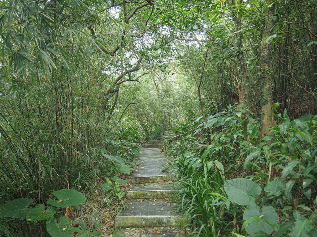
A couple of fern-topped pavilions are gathered around the bottom of the trail, and a sign tells you all about the endangered Satyrium formosanum butterflies that make their home on the soapberry bushes here.

It’s maybe not the most beautiful natural scenery you’ll come across if you spend a long time exploring Taiwan’s trails, but it has a certain kind of semi-forgotten-about charm.


Some steps join from the left, and a finger post indicates that the route to Mount Hongdan continues to head up to the right. A little further up, I passed another pavilion and one of the several “villas” that have accumulated on this slope. This one is Luotuo Villa (駱駝山莊) and it has a small grassy clearing out front of a single-story building with a small vegetable patch.

A little further up, the path meets a 5-way junction. One trail joining from the right is the one that you’d come up if you detoured to visit the Budda’s Light Cave. To continue to Mount Hongdan, take either of these trails heading leftish to either side of a stone marker.


The two trails promptly reconnect by a mountain shelter. This one has a large seating area and its own kitchen (all stowed away by the time I got there, I guess it’s busier in the morning).

It also has a couple of spots overlooking downtown Keelung.

At the junction just above the shelter area, I took the narrower left path towards the Rotary Tower (so named because it was funded by the Rotary Club).

The blue and white tower sits at the high point of a slight rise and a spiral staircase leads up in dizzyingly tight twists.


From the top, you can enjoy 360-degree views of the surrounding areas. To the south, Mount Wufen was hidden behind a low layer of clouds and the tall form of Keelung Golden Pagoda’s columbarium (基隆金寶塔) stood out from the rest of the landscape. The northeast potion of the view was filled with Keelung’s urban core collected around the harbour and out to sea, Keelung Islet is an easily recognisable landmark.

Looking west towards Taipei, I spotted the clutch of buildings around Taipei 101 and the nearby distinctive humps of Jiuwu Peak (九五峰) and Thumb Mountain (拇指山).

From the tower, steps lead down to a four-way junction. Head straight over here.


Then almost straight away, take the left fork and then promptly take another left. At all points, just keep following signs for Mount Hongdan (which is sometimes just called “trig point”).

Just before reaching the summit, a marker point right highlights the site of an old fort (竹堡遺址). The sign suggests it’s just 30 metres off the main path, so I went to have a look, but the fort has been reclaimed by nature. The fort dates back to 1884 when French forces attempted to capture Keelung. The French soldiers, looking up at the Qing army camp on top of Mount Hongdan saw the flags fluttering atop bamboo poles and named it Fort Bambou. The only discernible indications of the old fort now are the flattened area of land and a few walls hidden beneath the greenery.


Continuing up, take the left path at the next junction, then head straight past another turning on the left signposted as going towards Shixiang Cherry Park. (Later I came back and took the steps heading down to the cherry blossom park).

Shortly before reaching the true summit, my phone buzzed to say that it had located the Mount Hongdan digital gemstone.

The final few metres to the top takes you up a short flight of steps with a pair of white-painted foxes standing guard on pillars to each side.

Up close, the foxes look distinctly Japanese in their characteristics, and a little bit of research online proves this to be true. Originally the foxes stood guard outside a Shinto shrine built on the banks of Tianliao River (田寮河), or modern-day Ren’ai Road, Lane 37 (仁一路37巷). The shrine was dedicated to the Inari deity, a Japanese god known for covering a range of things including household and business affairs and harvests. The Inari deity is also known for its close association with foxes, and every Inari shrine has a pair of fox guardians where most temples have lions (or lion-dogs). Keelung’s Inari Shrine (like many Japanese shrines) got swept away by the changes after the end of World War Two, but its fox guardians were saved and moved here. They were named Mixi (彌習) and Mijia (彌佳) by Li Zenghuan (李增煌), the man who established the hiking trail here. Taken together, these names have an added layer of meaning and can be read as something like “the more you stay and play, the more beautiful you will find the scenery”. I’m not sure about that, but I certainly find the foxes rather charming.

The summit is marked with a concrete triangulation marker and a laminated peak sign listing its elevation at 208 metres above sea level.


Looking out to the coast, there’s a clearer view of Keelung Islet, and turning to face where I’d come from, I spotted the Rotary Club’s logo on top of the tower I’d climbed earlier.

Once I’d had my fill of the views, I headed back down the same way I’d come for a few meters until I reached the turn-off for Shixiang Cherry Park.


The trail heads down some steep steps for a short distance before arriving at this junction with a mountain shelter. There was someone bellowing out Taiwanese karaoke tunes within the shelter walls and the cherry trees on the slope beyond were mostly still dormant (I visited in mid-January).

Turn sharply left onto the path and follow the path along the top edge of the cherry park.


There were a few bursts of pink visible among the otherwise green and grey landscape.

The trail reaches a pavilion decorated with floral motifs. Here you can either head straight over or turn right. Both paths reconnect after just a short distance.


I took the up and over route. The trail heads past another mountain shelter, then past some exercise equipment before starting to descend down steps.

At the bottom of the steps, the trail rejoins the one heading right from a couple of photos earlier. Turn left onto the concrete path here.

I met a local guy sweeping the path free of debris here—not an uncommon sight in Taiwan. Continue to head straight, ignoring the turnoff to Yanping Street.


The trail continues down to another junction. Turn right here and walk towards the red and white mast. Once you’re almost right below it, the path cuts in front of a temple.

Metal grillwork protects the deities inside from hikers with nefarious intentions.


Once you’re past the temple, the trail becomes more of a track. Keep following the main track as it heads down. There are several lanes or paths branching off, but just stick to the main route (it’s easy to figure out which this is).


The track leads down to something that has a censor with incense burning outside, but which seems to be more of a mountain living room than a temple. Follow the lane as it takes a right turn here, then once you reach the next T-Junction, turn left.


The path heads past an algae-topped basketball court and before long, it ends in front of Nantian Temple (南天宮).

The temple’s primary deity is the Jade Emperor, and the interior is rather grand compared to the other temples I’d seen in the course of this walk. As I was walking away, A man rode past on his scooter and—without stopping—slowed to a crawl and nodded a greeting to the gods before continuing on his way.


There are at least four routes heading down to the down from Nantian Temple. Standing with the temple at my back, I took a right turn and then headed down some steps almost straight ahead.


After a brief descent, the trail takes a sharp right turn to run along a very slippery path, then turns left again down another flight of steps.

A footbridge at the bottom of the steps saves you from having to dodge through the traffic.


I crossed over then on the far side, turned right onto Qushui Street. At a dessert shop on the corner of Lane 64, turn left.


From there, it’s less than 100 metres back to the train station.
HOW TO GET TO MOUNT HONGDAN
Google Maps address: The walk starts and ends from Sankeng Train Station. If you’re looking to use your own transportation, there should be lots of options for scooter parking, but car parking might be a bit harder.
GPS location:
- Baoming Temple trailhead – N25 06.910 E121 44.590
- Nantian Temple trailhead – N25 07.325 E121 44.650
Public transport: The easiest way to get here is by train. From Taipei, board any train bound for Keelung and alight at Sankeng. Or, if you’re coming from elsewhere, bard any train that stops at Qidu or Badu and transfer onto a Keelung-bound train.
Further reading: You can read more about this trail in English here. And the ever-wonderful Tony Huang has written about it here.
MOUNT HONGDAN TRAIL MAP
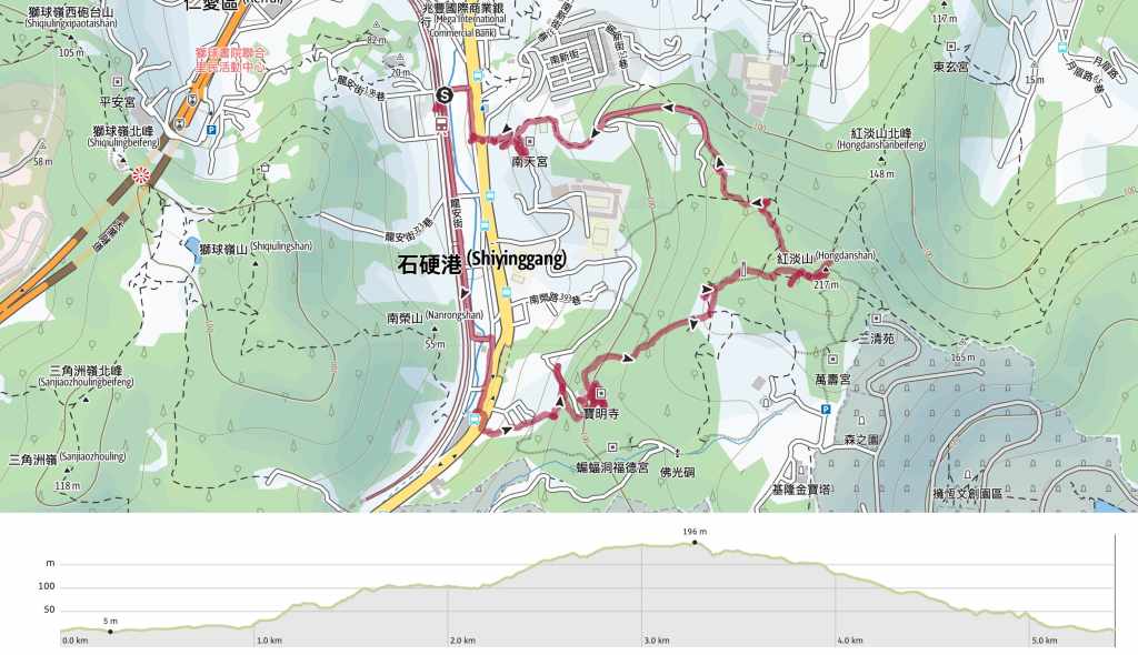
GPX file available here on Outdoor Active. (Account needed, but the free one works just fine.)

Good morning.
Finally sitting down to read your postings … yeah I posted a comment on the Dakeng 10 & 9-1, forgot to log in first, hence “Anonymous”.
Enough of light intro …
The link to this MOUNT HONGDAN shows … Oops! That page can’t be found.
Just to let you know.
Regards. Teo Kin Hua
LikeLike
It has finally seen the light of day!
LikeLike