
MSTW SECTIONS 16-22
While I was planning my MSTW adventure, day six was the one I was most worried about. This is because I knew it would see me walking over 30 kilometres combined with a pretty hefty elevation gain. On top of that was the fact that the steepest and toughest part of the day would be done on a footpath rather than roads, and after my energy had already been sapped by 16 kilometres of road walking. My worries weren’t entirely unfounded—I arrived at the B&B with half an hour to go before darkfall—however, I coped with the physical challenge better than I had expected, and after a night’s sleep, I felt right as rain and ready to keep moving.
The highlight of this section is passing through Danaiku Nature Ecological Park and then following the pretty (but steep) Limei Refuge Trail up to Lijia. The evening’s dinner was also pretty damn good.
MSTW PASSPORT STAMPS: None on this stretch.
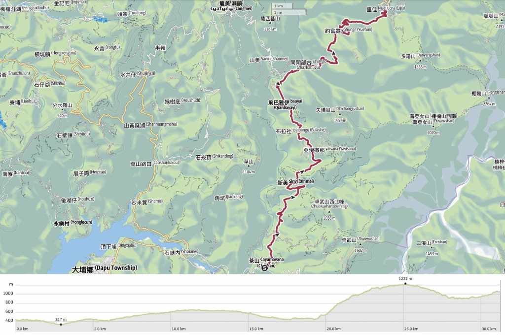
DISTANCE: 31.2 kilometres.
TIME: About 10 hours.
TOTAL ASCENT: A little over 1,400 metres with about 800 metres of descent.
DIFFICULTY CONSIDERATIONS: The length of this section along with the elevation gain make it a pretty tiring day. The trail portion between Danayiku and the top of the Giant Stone Slab Trail is the hardest part of the walk on account of the steps’ steepness. Elsewhere, the incline is smooth and gradual. Even the trail portion is well-maintained.
FOOD, DRINKS & PIT STOPS: Starting so early, there weren’t really many places open in Chashan to pick up snacks. Luckily, I had expected this and had brought snacks with me from Dapu to last me as far as Dabang. There is a relatively well-stocked convenience store as well as a few small restaurants in Xinmei. Danayiku also has a restaurant and couple of snack stalls (although vegetarian options are limited). I didn’t see anywhere to buy snacks in Lijia, but I was able to get dinner here by pre-booking through the B&B.
TRAIL SURFACES: Well-surfaced road, wood and earth steps, and farm track.
SHADE: This is one of the shadier days, but I still made ample use of my sunhat.
MOBILE NETWORK: There were a few spots where my signal dipped, but it was mostly OK.
SOLO HIKE-ABILITY: As long as you start early enough to complete the walk before nightfall, there’s nothing to make this particularly dangerous or risky for a solo hiker.
Jump to the bottom of this post for a trail map, GPX file and all the other practicalities.
DETAILS & DIRECTIONS:
Knowing that I was one sleep away from the hardest day of the trail, I got to bed early and was asleep by 9. As a result, I woke up feeling well-rested and mostly no longer sore ten minutes before my 6am alarm. I had all my stuff packed and ready to go by 6:30, by which point, my lovely hosts had got breakfast ready.

As with dinner the night before, they had prepared more than I could possibly eat. Fried eggs, buns, three bananas, egg rolls, crispy seaweed, sweet potato, and they sat chatting to me over their morning coffee as I ate. Mr Hsu also demonstrated his uncanny cat-whispering abilities by letting out a call that brought four of his five cats scrambling from all corners of the garden to find him. They pointed out a female Daurian redstart who was sat on a trellis above an oblivious tortoiseshell. This then led into a brief discussion about migrant birds.
A few minutes after 7 o’clock, I was ready to go after repacking my bag to accommodate the extra banana, sweet potato, and sugar cubes made from ginger and homegrown sugar cane.


From the farmstead, I navigated back to the main road through Chashan, then turned right.


A few people were already out and about on the village’s hufu-lined and decorated main street.

But as I made my way past stores and churches, I soon found myself on the quiet of the road towards Shanmei. As seemed to be the routine, I received my first order of a lift barely 20 minutes into the walk. This time from a woman in a blue truck.


With the air still cool, I tried to maintain a good speed so that I could get a good chunk of the road walking done before the sun began making itself impossible to ignore. But the downhills were tough on my shins, so I ended up turning around to walk (slowly) backwards. During one such rear-facing portion, I was startled by a pair of Swinhoe’s pheasants who leapt from the grass verge to fly over my head.


07:55 – A toilet block and a pavilion mark the entrance to the Riverview Pavilion Trail. A sign here indicates that the trail is 300 metres long, and at first I decided not to walk it because an extra 600 metres feels like a lot when you’re already doing a mammoth day. But then I realised the first 180 metres follow the road, so I decided to do take a look. The start of the walk is decorated by depictions of white deer. This animal is significant to another indigenous group in Taiwan, the Thao of Sun Moon Lake.

The pavilion offers beautiful views looking both up and down Zengwen River, but I was disappointed to learn that I was still technically within the boundaries of Chashan Village.

As it turned out, it was lucky that I paused, because doing so made me realise I had a sweet potato seepage problem that needed addressing (which I did by eating the offending tuber).
Back on the road, I heard my first white-eared sibia, signalling a shift into a new aural environment. And by the time I completed day six, the sibias and the Steere’s liocichla that invariably accompany them had become the dominant trailside tweeters.

8:58 – Passing over Xinmei Bridge. I passed at the same time as a rider stopped to photograph her bike. I have never been very plugged in to the auto enthusiast community anywhere I’ve lived, but here in Taiwan, people love to photograph their car, scooter or motorbike by landmarks that they’ve driven or ridden it to. Perhaps that’s a global thing and I just never noticed.

I found myself walking through the fallen leaves just to have a little extra cushioning between myself and the road.


Watching where I stepped gave me plenty of small excitements to observe, like these freshly hatched lychee stink bug nymphs in the bright coral hue of their first instar, or this leaf dropped by someone large.

9:34 – The settlement Xinmei (新美 or Sinvi in the Tsou language) is split into two main sections. In the first, I passed large racks of coffee drying in the morning sun.

Between the built up areas, the slope was covered with tall, straight betel nut trees. This crop is a popular way for mountain landowners to earn a little extra, but planting them often means clearing deeper-rooted trees off the land and leaves the slopes more prone to landslides.

09:46 – At the junction, you can go either way. Both roads go around or through Xinmei. I chose to take the lower route on the left that would take me past the school.


The school is absolutely tiny and decorated with the blue, white, black and red colours that are seen in many of the Tsou’s tribal patternwork. From the school, the lane runs up to join the Xinmei Industry Road where I turned left.

9:55 – Xinmei has a couple of stores where you can grab supplies if needed. I got a can of coffee to fuel my onwards journey.

Rural life. A sun-sleepy dog and drying clothes. As I passed, I could hear the sound of hymns carried out through the windows of the village church.


10:22 – After climbing away from the village, I found myself at a junction decorated with owls bearing the village’s name. MSTW signage directed me leftwards and down again.


Passing through pretty farmland, I ate the last of the breakfast bananas that my host had given me. I figured that I had to keep my energy up because I had a tough climb after a long hard slog, and letting my energy levels dip would be a bad idea.

Many of the houses and farms I passed had guard dogs. Most were either chained, fenced in, or else not too bothered. This poor chap had to suffer the indignity of being stick-chained. This method gives the dog more freedom in where it can go, but it forces them to walk slowly and carefully so as to not let the stick bash their shins. His companion (obviously less wont to wander) was free to roam as he pleased, and I feel like this one’s expression tells you exactly what he thinks about that!


11:16 – Between Xinmei and Danayiku, the road passes through another small settlement.

11:51 – On the final approach to Danayiku, I passed Fumei Suspension Bridge. You don’t need to cross it, but it’s worth walking to the middle at least to appreciate its gigantic span.

Head through the archway leading into Danayiku Ecological Park, and make your way towards the ticket gate.


The walls from the archway to the ticket booth are decorated in art showing Tsou stories and culture.

A full-price ticket is $150, but the guy in the booth took one look at my pack and asked if I was walking the Mountain to Sea Greenway, and when I said yes, I told me it would just be $100. I’m not sure if this is an official thing or just done when they feel like it—either way, I wasn’t going to question the discount. I asked him if there was anywhere I could fill up my empty water bottles, and he directed me to the restaurant close to Danayiku Suspension Bridge.

Past the ticket gate, turn right to head uphill towards the smell of barbecued meat. I got a coffee from one of the vendors near the carpark and then continued on my way.


You’ll see lots of fish motifs wherever you look. That’s because the park came about as a result of a communal effort to rehabilitate the river’s population of shoveljaw carp. Traditionally, the Tsou people’s hunting grounds were passed down from one generation to the next. Each family had a plot of land in which it could fish or hunt, and any chase that led the hunter onto another family’s plot had to be marked by splitting the gains with that family. This method of living off the land was able to sustain the tribe for generations, but after the ceding of Taiwan to ROC forces, newcomers moved in, bringing more destructive hunting and fishing practises. Fish were poisoned or stunned using electrofishing practises, and the Zengwen River’s population of carp plummeted. Village elders were dismayed by this, and after much discussion, a radical solution was proposed. Families were to give up their land rights, and instead, the land would belong to the whole community. Villagers went to the upper reaches of the river to collect fish fry and reintroduced them to their own stretch of the waterway. A no-fishing zone was established, and then the community set about guarding their new fish charges fiercely. In the early years, a 24-hour guard was mounted against would-be-fishermen, and village youth would take turns patrolling the banks and taking anyone who tried to evade them to the local police station. Their efforts paid off, and very rapidly, fish populations were replenished, but rather than returning to hunting fish in order to make a living, the villagers invited outsiders to come in and admire the fish and other aspects of their culture. A display house was built, a performance hall constructed, and restaurants established.
I visited Danayiku a while back with Travel in Taiwan magazine and spoke to some of the villagers who live and work here. Most of them hail from Shanmei Village (山美 or Saviki in the Tsou language). They say it’s a way for them to make enough money to support the community and gives them both motivation and opportunity to keep the culture alive. The guy who showed us around was a fluent speaker of the Tsou tongue and said that the park’s establishment has led to several youngsters choosing to return to their community rather than become lost to the cities.

I popped into the restaurant to fill up my water bottle and as I was there, I watched a group being instructed in how to fashion a cup from two pieces of bamboo and some twine. I had lunch here on my last visit, and it was excellent, but I rarely feel like eating much while walking, and I knew I had dinner waiting for me at the end of the day, so I just loaded up on water and passed through.

The base of the suspension bridge’s supports are decorated with artwork showing how the Tsou used to spear-fish at night using a flaming torch to illuminate the dozy fish.


At the southern end of Danayiku Suspension Bridge, there’s one final store selling drinks and barbecued meats. I turned right to take a look at the fish viewing areas before coming back here to cross the bridge.

There is something rather idyllic about this place. People were dotted around the pavilions just daydreaming or lying down for an afternoon nap.
In the river, there are fish viewing areas (indicated by 賞魚區) and paddling areas (泡腳區).


The fish are really plentiful in the fish viewing areas, and from above, some of them have the most beautiful light blue tinge to their fins. It’s hard to see because they move so fast, but if you happen to catch one head-on, their mouth is a comically straight, square line (hence the name shoveljaw carp).

It is possible to cross over the river from the fish-viewing area and continue uphill without crossing the suspension bridge, but I didn’t realise that until later, so I headed back up from the fish-viewing area to cross over Danayiku Suspension Bridge.

Looking down from the bridge, I spotted someone setting up a “lunch in the river” set. This is something the park’s restaurant offers (via pre-booking) throughout the warmer months of the year. Even from this high up, all those slices of barbecued meat, onion and crispy pumpkin look delicious.

Looking upstream towards the fish viewing area. The beauty of this place makes me feel so very grateful to the Tsou people both for their efforts in preserving it and in their generosity in opening it to outsiders like myself. If I lived in such a beautiful place, I’m not sure I’d want to share it.

The building on the far end of the bridge is decorated with the eyes of a fearsome-looking mountain scops owl. Owl symbols can be seen throughout Tsou villages because the bird features in Tsou legends. There are a couple of versions of the story. In one, some children are left at home and told that if the hear the “gui gui” call at night, they mustn’t copy it. But children being children, they do exactly what they were told not to, and upon uttering the sound, the owl-beast broke into the children’s home and devoured one of them. When the parents return home to find the owl squatting in the house, they set about it, attacking it with their blades. Each chunk of flesh hewn from the beast turns into a small owl which then flies off into the night with a high-pitched “gui gui”. Thankfully, by the time the parents were finished, the resulting owls were all tiny-far too small to bother a human. Spend a night near the mountains in Taiwan and you will almost certainly hear its distinctive call.


12:51 – In an ideal world, I wouldn’t have been beginning the toughest part of the day under the hottest sun, but given where I started and ended, there really wasn’t any way around it. From the structure here, I took the steps climbing upwards (signposted as being Limei Refuge Trail). The path tracks up to a clearing with a view of the river valley before starting to descend again.

13:02 – After about ten minutes, I spotted the trail I could have taken from the top end of the fish viewing area. Here, the MSTW heads straight on past a sign displaying a leg-tremble-inducing elevation profile.


There are a handful of springy rope bridges on this walk, but for the most part, the trail is wooden steps. The trail used to be the main means for Tsou villagers to transport goods between the two tribal villages of Lijia (里佳) and Shanmei (山美), but it fell into disuse during Japanese rule after a second trail was built. That second trail was all but wiped out by Typhoon Morakot in 2009, but as the Shanmei Villagers stitched their lives back together, they asked for assistance in reestablishing this old route.


Thankfully, the forest is beautiful and vibrant, because the beauty of it helped to distract from the effort. Whoever is responsible for managing the trail must be aware of how taxing it can be because rather than placing distance markers every 200 or 100 metres as is customary, they were placed every 50 metres! I did not know that 50 metres could be so far!

I passed a few hikers coming down—a couple who said they were walking the MSTW but in the opposite direction and in day-long sections, and a larger group that was so loud that I feigned having a lower level of Chinese comprehension to avoid prolonging the interaction. By the final rope bridge, the springiness was like an extra test to tired legs.

14:28 – After making it to “the end” of the trail, I was miffed to realise it was not the end at all. There was still another 800 metres to go until I was through with steps.


Before setting off up more steps, I took the short detour down to a pavilion overlooking Danayiku Ecological Park. The afternoon haze that seems to be a feature of the local microclimate has settled over the valley, making the view feel fuzzy and unfocused.

Heading up again through more bamboo, I startled a nearby muntjac and sent a monkey scrambling up the steps in front of me.

14:46 – Soon, I found myself walking beside the 700-metre rock slab that this trail is known for.

14:47 – At a junction, I had the option of taking a shortcut to the carpark by heading left, or taking a slightly longer route to walk up the rest of the exposed rock face.

I took the second option because, at this point, what is a couple of hundred extra meters. And I’m glad I did because it’s a pretty impressive feature.

A sign partway up explains that this was previously a creek bed, but that the landscape changed after a particularly big typhoon, leaving the rock bare and dry.

14:58 – At the top of the giant rock slab, the path turns left to head back into the trees.

13:10 – Then before long, I found myself joining the track that would (after an interminably long time) lead me to Lijia. Head straight here.

The track cuts through bamboo forest, and more than once, I sent monkeys and muntjacs scattering. I occasionally saw the flash of the latter’s white tail, but the monkeys mostly grumbled at me from their unseen arboreal vantage points.

15:38 – The weather here really is bizarre. The late afternoon sky hangs heavy like this. Down on the coast, this would portend rain, but up here, it doesn’t seem to. (At least, not always.)


15:51 – At this odd junction head straightish (on the lefthand track) and continue down. A little further beyond this, two workers that is passed fixing the road higher up paused to ask if I wanted a ride in the back of their truck. A little later, some other people also offered a ride.


The road was long and draining after the rest of the day’s walking and I called my parents to chat and take my mind off the soreness in my feet. I also spotted a maroon oriole (the second of this journey), so that helped lift my spirits.

The scenery was also something of a balm. No matter how weary, seeing this is restorative.

16:50 – As I drew close to Lijia Village, I turned off the road to walk towards this unfinished pavilion.


Then from there, followed the path heading up alongside the watercourse to a bridge.

17:03 – Heading over the bridge, I initially thought I needed to take a right turn once I’d crossed the water, but MSTW signage directed me to the left instead.


There, I soon found a set of steps, and while they were neither signposted nor shown on the map, they seemed to be heading straight up to the place where I was staying, offering a much-desired shortcut.


17:18 – Sure enough, the steps let out right in front of the homestay where I would be spending the night, and the aunty running the place sprang up excitedly when she saw me. Apparently, she’d called earlier but had been unable to get through to me, so she was very happy to see me arrive safely. She showed me to my room and told me to shower and do any washing I needed to do and she would take me to get dinner at 6 o’clock.

Washed and somewhat refreshed, I left my room ready for dinner, and was not disappointed. The nearby restaurant served the most delicious Tsou cuisine, in such volumes that I was unable to finish it all! There was another group in there with me and they’d apparently seen me walking the road earlier in the day. Also present were a pair of very fluffy cats and some dogs (the other family was not a fan of these), and the chef’s two children. One was a big-eyed toddler who barreled around the place happily brandishing his toy truck, and the other was his 9-year old sister who-after a period of initial shyness-came and sat next to me. She told me her English name was Hannah and that she liked to bully the boys in her school.
After dinner, I shuffled back down the lane to my B&B. There was a large group of nurses also staying there. They’d brought their own food and were barbecuing it on the front porch. I was invited to drink with them, but after such a long day, I wanted nothing more than my bed.
GETTING THERE
GPS location:
- Start point – N23 17.905 E120 39.930
- End point – N23 24.255 E120 43.220
Accommodation:
Staying in Chashan – There are a number of options in Chashan, but I highly recommend the place I stayed at. It was quite, comfortable, had great food, lots of cats, and the owners were ever so hospitable.
- Name in Chinese: 茶山開元農場
- Name in English: Chashan Kaiyuan Farmstead
- Address: 嘉義縣阿里山鄉青山產業道路96號
- Contact: 0932773883
- Cost: $1,200 for a double room including breakfast. You can also ask to have dinner for an extra cost, (which I think varies depending on what’s available).
- Booking methods: telephone
- Clothes drying facilities: There is a spin dryer and a drying rack to hang your clothes on
Staying in Lijia – There is one well-known hikers’ accommodation in Lijia, as well as a few campsite options. I stayed in the former. It provides breakfast and will help you book dinner at a nearby restaurant for an extra fee ($300).
- Name in Chinese: 嘉娜百藝工坊
- Address: 605嘉義縣阿里山鄉里佳61號
- Contact: 052511383
- Cost: $2,400 for a double room including a fullsome breakfast. (Dinner can be pre-booked nearby at the time of booking.)
- Booking methods: telephone
- Clothes drying facilities: There is a spin dryer and a place to hang up your clothes.
MOUNTAINS TO SEA GREENWAY DAY 6 TRAIL MAP
GPX file available here on Outdoor Active. (Account needed, but the free one works just fine.)

great job! Nice to read.
LikeLiked by 1 person