
Grand Forests, Aboriginal Stories and Logging History on Tefuye Historic Trail
I walked Tefuye Historic Trail as part of a long-distance hiking route called the Taiwan Mountains to Sea Greenway. This Tefuye section of the long trail is so lovely that I don’t think it should be limited to just the smaller group of hikers wishing to take on a multi-day challenge. So I will cover it here as a stand-alone hike.
The trail was originally part of a trading and hunting route between Indigenous villages, but when the Japanese colonizers turned up with their surveyors and insatiable need for quality wood, they built a logging railway here. In fact, this was one of several mountain railway branch lines built by the Japanese to help them in their efforts to extract precious red cypress wood from Taiwan’s high mountain forests. It would have connected to the Dongpu Branch Line at Zizhong (the starting point of this walk), and from there, it was just a short ride down towards the main line of Alishan Forestry Railway.
There hasn’t been a train on this section of track for many years now, but plenty of remnants remain visible — some have even been incorporated into the trail itself.
Distance: About 12.5 kilometres, but many people prefer to walk only the flat section (the first 3.5 kilometres).
Time: 5-6 hours should be enough to complete the whole trail.
Difficulty (regular Taiwan hiker): 4/10 – Taking the transportation, length and trail conditions into account this is an easy-moderate trail for most regular Taiwan hikers.
Difficulty (new Taiwan hiker): 5/10 – If you’re new to hiking in Taiwan, this walk (in its entirety) would be moderately difficult given the amount of steep elevation gain and loss. However, if you choose to walk only the first 3.5km and back, it would be more like a 2/10.
Total ascent: About 630 metres with an equal amount of descent (the descent is on the way out, the ascent is on the way back).
Water: A litre should be enough on a cool day. You’ll also want to take some snacks to fuel your legs for the climb. On weekends, there’s usually a vendor selling bottled water and aiyu jelly beside the trailhead, but you’d best go prepared.
Shade: This is a very shady walk.
Mobile network: Some weak patches, but generally OK.
Enjoyment: This is an excellent walk for forest lovers. Whether you have dappled sun or atmospheric fog, the scenery here is truly spectacular. And you don’t need to take my word for it either — this route has been voted one of the 100 best hikes in Taiwan by local hikers.
Bathroom facilities: There is a toilet block at either end of the trail (but you’ll want to bring your own toilet paper).
Route type: There and back
Permit: None needed
Jump to the bottom of this post for a trail map and GPX file.

Somehow, the only photo I managed to take of the trailhead was this one showing one of the Mountains to Sea Greenway stamps in front of the trail’s name sign. (The MSTW has a kind of “trail passport” in which hikers can collect several stamps along the way.)

The area around the trailhead is a popular stopping point on the way up to Yushan National Park because it has a lookout point where you can see the sunrise over Jade Mountain with a sea of clouds lapping at its foot. (Or you might just see a wall of clouds.)

The first 3.7 kilometres of the walk are exceptionally gentle and easy.

The trail winds through pretty forested scenery along the course of an old logging track, one of several in the area that were built by the Japanese to carry lumber from deep in the hills down towards the main line from Alishan on towards Chiayi.

Until October of the year before, the trail had been closed for maintenance, so the trail infrastructure like steps and bridges all felt strong and in good condition.


In some places, the old rails have been left in situ for walkers to follow.

As with other rail-revival projects that can be seen across Taiwan, the landscapers have opted for a mixed approach to the materials that results in a more organic and natural feeling visual experience. Sometimes the rails are filled with gravel, other times they’re worked into a decking bridge, and in other places, the sleepers are left in place too.

I think this was the only spot where you could see out from the trail at all. Just a glimpse of distant slopes.

A couple of kilometres in, I came across a turn off leading to Mount Dongshui (東水山). I walked this way on day 9 of my MSTW adventure. The trail is significantly harder than Tefuye Historic Trail, but it also passes through some exquisite forest.

Here, as with the other places where the original trestle bridges are still pressed into service, there seems to be a built-in secondary option for if or when the old woodwork fails.


Nubilaria arisanensis and some type of mushroom, both of which were seen just beside the trail.

Another of the trestle bridge sections. This one had been preemptively closed on account of its dangerous condition, but it didn’t really appear to be in any worse nick than the rest.

You will know when you’ve arrived at the spot where most hikers turn around because it’s usually full of people stopped and enjoying a snack before they retrace their steps. You’ll also know because there’s a pretty big sign letting hikers know that the onward path is no longer pleasantly flat, but relentlessly steep.

If you’ve got the knees and the energy for it, I would say it’s most definitely worth continuing onwards and downwards, at least for some of the way, because the scenery is beautiful and dramatic, and there are far fewer people. (Also, if you’re planning on collecting all of the Hiking Biji digital gem stones, then you’ll need to walk the whole trail.)


Most of the time, it was just me and the trees.


Acorn shells and the shell of a cicada. It seemed pretty fresh, but I didn’t hear any calling, and it would be pretty odd for them to emerge so early in the year (I was there in March).

Fog hung thick in just this one small clearing. It was so thick, that it had created its own microclimate and I was briefly fooled into thinking it had started raining when in fact it was just the condensation dripping from the trees.

A side trail leads to Mount Tiziban (梯子板山). I didn’t take it, but I was told by Teresa and another couple who did, that it’s a pleasant and not too challenging addition to the route.

There’s lots and lots of lichen draped all over the place. I love the way this variety grows. It looks so pretty.

Steep steps mark the final descent to the southern trailhead.


When you emerge, you’ll find a car park with a pavilion and a small toilet block. It’s unlikely you’ll find people parked here though because the road up to here from Tefuye is a winding, single-lane farm track that is probably not pleasant in a car.

If you arrived at the top trailhead in your own means of transport, you’ll have to turn round and head back up at this point. But if you’re using public transport, you could walk the 6-7km down the track to Tefuye Village. Alternatively, there are names and numbers of several local drivers who are willing to take people down to the village for a fee.
How to get to Tefuye Historic Trail
Google Maps address: The trailhead can be found along Provincial Highway 18, right beside a spot that has become famed for sunrise viewing. There is space to park cars and scooters along the road here.
GPS location: N23 29.040 E120 49.810
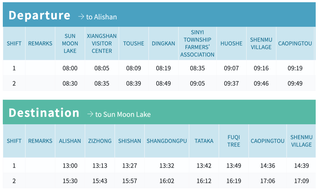
Public transport: Attempting this walk using public transport would be possible, but it would require some tight planning. The 6739 bus stops at Zizhong bus stop, but only two buses per day (weekdays) and four per day (Saturdays and Sundays) pass through this spot. On weekdays, one departs from Alishan National Forest Recreation Area to Sun Moon Lake and another does the same route but in reverse. (On weekends, a second, later bus is added in each direction.)
The times have changed in recent years though, so make sure to check on the Tourist Shuttle website for updated schedules and information on how to book tickets. (This bus route serves hikers going to Jade Mountain, so it requires booking at least two days prior to your journey.)
Tefuye Historic Trail Map

GPX file available here on Outdoor Active. (Account needed, but the free one works just fine.)
