
Home to an impressive clutch of peaks including Taiwan’s highest, Jade Mountain, Yushan National Park is a popular destination for both local and international hikers. However, as with Taiwan’s other wildly beautiful national parks, the flow of people in and out is strictly monitored, and most trails can only be done with a permit. Luckily for all my fellow late planners, this walk is both exceptionally scenic and entirely permit-free.
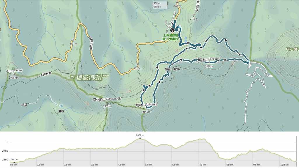
Distance: 10.6km – It can be shortened a little if you take the shuttle bus back down.
Time: 5-6 hours – We took six hours to walk this with a lunch break and plenty of photo stops.
Difficulty (regular Taiwan hiker): 4/10 – For old hands, this is on the easy end of moderate. Challenging elements come from figuring out how to get there, and the amount of steps climbed at a higher elevation.
Difficulty (new Taiwan hiker): 5-6/10 – This should be a very doable walk, even for those new to hiking in Taiwan. Just take it slow and give yourself plenty of time to manage all those steps. (Or opt for a shorter route.)
Total ascent: A little over 500 metres. The elevation is pretty high though, so it feels like more.
Water: I took a single 0.5L bottle and topped it up from the water dispenser at the Lulin Mountain Trailhead. You’ll also need to bring snacks. There aren’t any places to buy provisions once you get up here.
Shade: There are long sections without any shade and since the effects of UV radiation are more pronounced at higher elevations, make sure you’re adequately protected.
Mobile network: Clear throughout.
Enjoyment: If you want a taste of Yushan National Park but were unable to get the permits in time, this is a solid alternative.
Bathroom facilities: There are toilets at Shandongping Carpark, Paiyun Hiking Service Centre, by the Giant Hemlock and close to the Lulin Lodge trailhead.
Route type: Loop
Permit: None needed
Jump to the bottom of this post for a trail map and GPX file.


The walk starts from Shangdongpu Carpark. The road up from here as far as either the Yushan Trailhead or Lulin Lodge is marked on the map as being as accessible trail. And while it’s true that there are no steps or barriers, it’s also true that there are no seats along the way (save for those outside Paiyun Hiking Service Centre) and the hill is probably a bit too steep to be considered properly accessible.


After about five minutes, we arrived at Tataka Police Outpost. They have a fleet of very cool 野狼 125 bikes parked out front.

Paiyun Hiking Service Centre is right next to the police station and it’s the last place with water and toilets for another 30 minutes. The signs in the toilets have one of my all-time-favourite English typos. They implore people not to throw tissue paper in the “stinkpot.” You’ll also find a small gallery full of hiking safety and preparation tips (honestly, if you’re here and setting off for Jade Mountain and this is the first time you’re reading these, it’s a bit too late).

Tall pines line the road and we caught our first (but not last) glimpse of a white-whiskered laughingthrush.

A side trail on the left leads down to Tataka Visitor Centre.

But if you keep walking up the road, you’ll soon come to this giant hemlock tree. According to a sign placed nearby, the tree is about 600 years old and supports a whole world of different plants.

The hemlock tree stands at the junction of two forestry roads. You can go both ways, but the walk covered here heads to the right. Doing it this way doesn’t mean you can avoid the steepest section, but you’ll be walking down it rather than up.

The track leading to Lulin Lodge is the old Yushan Forestry Road. It’s flatter than the earlier section of road. And if you keep your eyes open, there are many signs of the park’s wildlife to be spotted. This smeuse and the nearby piles of fresh droppings hinted at nearby deer—a hint that was followed up by a flash sighting of chestnut-brown fur.

In clear weather, Lulin Observatory is visible in the distance. And part-way along the track, we passed a shortcut on the left that can take you to Lulin Saddle. (If you want a shorter walk, taking the shortcut and skipping Mount Lulin would have cut the walk by about 2 hours).


Lichen and views, both are available in abundance as you go higher up.

As you near the end of the still-maintained section of Yushan Forestry Road, you’ll hit a junction. The trail up to Mount Lulin continues on the left, but if you want to check out Lulin Lodge, you’ll need to make a brief detour to the right.

This is where hikers would have stayed on their way to climb Jade Mountain back in the early days of mountaineering in Taiwan. The building that’s here now is a reconstruction, but when it was originally built, the wood used was Formosan cypress tree wood from from Alishan’s giant cypress groves. The only people who can stay here now are Forestry Bureau workers.

After checking out Lulin Lodge, we retraced our steps as far as the previous junction and headed up to Lulin Mountain Trailhead. There’s another toilet block here and a water dispenser, and I advise you to make use of both.


From the trailhead, steps climb steadily up through a green tunnel all the way to the summit of Lulin Mountain.

Although the trail is pretty shaded, enough sunlight filters in to give a beautiful scenes like this.


There are three main plant/tree species that you can see on the way up. The first is arrow bamboo. Its slender stalks are rarely much thicker than a finger, and the papery leaves add a sandy hue to the ground. The other two are both types of pine. There are Armand pines and Taiwan red pines, which can be distinguished most easily by the size of their cones (Armand pine cones are larger and more elongated compared to the more spherical red pine cones).

It took us about 30 minutes to reach the summit of Mount Lulin. The summit has a stone marker and a couple of benches, but it’s not particularly noteworthy.

However, just a very short distance further away, we got the first taste of what this walk is all about: views. Big, big views.

Another distinguishing factor of this trail is the preponderance of Eurasian nutcrackers. I’ve not seen them anywhere else in Taiwan, but they were here and easy to observe both times I’ve visited.

As we made our way down from Mount Lulin, we passed several alpine pools. They were pretty dry, and footprints of the various animals that live up here could be spotted in the mud. They weren’t crisp enough to identify, but the park is home to serow, sambar deer, and yellow-throated martens, so it could have been any of them.

At the junction, keep leftish and follow the signs for Linzhi Mountain. (The other trail offers an alternative route back down to Jade Mountain Trailhead that bypasses the peak.)

The views keep coming, one after another, and thanks to the way the path twists and turns, you get lots of tree-framed views of the trail ahead.

Sambar deer droppings on one of the grassy meadows.

Another shot of a nutcracker. They were so much fun to watch. They’d fly big swooping circles before coming back to land, or else do some of the cracking that gave them their name. (I’m not actually sure what they were cracking though, I couldn’t see.)


The second time we found ourselves at Lulin Saddle, we continued straight over. (Yushan Forestry Road is just a few metres to the left of the path here.)

Like Lulin Mountain, Linzhi Mountain has a stone marker bearing its name and elevation. At 2,854 metres above sea level, this is the highest point of the walk.


The summit has some super views in all directions.

It is also entirely exposed, so after enjoying the views for I bit, I shuffled off to find shade while my hiking companions finished up their photographing.

The descent from Linzhi Mountain to Jade Mountain Trailhead is the steepest section of the whole walk.

As we made our way down, we got some final views of Jade Mountain covered in a dusting of snow from a cold snap that had brushed over Taiwan the week before.

Hikers making their way down the Jade Mountain trail towards the trailhead.


When we arrived at the trailhead, there was an almost full minibus waiting to take hikers down, so my group had to wait for the next.

Instead of waiting with them, I decided to take my chances and walk back down the Forestry Road to the carpark.

As it happened, I was able to make it back to Paiyun Hiking Service centre ahead of them, but as I was inside using the loos, they passed me on their way to the carpark. (Yes, the stupidly competitive part of me was vexed.)
How to get to Lulin and Linzhi Mountain
Google Maps address: This walk starts from the spacious Shangdongpu Car Park.
GPS location: N23 28.900 E120 53.195
Public transport: There is a bus here, but it isn’t the most helpful unless you’re planning to stay at Dongpu Lodge overnight. The 6739 Taiwan Tourist Shuttle stops here as it travels from Alishan to Sun Moon Lake. There is only one bus in each direction per day. One leaves Sun Moon Lake bus station at 8 am and arrives at Shangdongpu around 9:50 am. The other departs Alishan Transport Station at 1 pm and arrives at Shangdongpu about half an hour later.
Shuttlebuses: The shuttlebus service takes hikers from down from Yushan Trailhead to Shangdongpu Carpark. (Or up from Paiyun Hiking Service Centre up to Yushan Trailhead.) To take the shuttlebus, you just need to wait for the minibus to arrive, let the driver know that you want to get in and pay $100 per person. The shuttlebuses come roughly every 20-30 minutes, but they don’t leave until they have enough hikers to fill the seats.
Further reading: I have also written about these trails as well as some other attractions around this corner of Nantou in an article here.
Lulin and Linzhi Mountain Trail Map
GPX file available here on Outdoor Active. (Account needed, but the free one works just fine.)
