This is another one of those places that I’ve been meaning to get to for literally years. (I have a real thing for caves with temples in them, so of course, this had been in my plans for a while.) The cave temple itself can be reached on a scooter, but since it is always more fun to walk there, we decided to visit it in the course of this short and sweet loop.
Distance: About 4.5km with a great number of options for extending the walk (and one for shortening it too).
Time: 2-3 hours. We spent 2.5 hours here.
Difficulty (regular Taiwan hiker): 3-4/10 – For people who are often on Taiwan’s trails, this walk probably deserves to be rated at the challenging end of easy. It’s short, but both ascent and descent are wicked steep, and there are so many intersecting trails that you really need to know where you’re going.
Difficulty (new Taiwan hiker): 5-7 – This walk belongs firmly in the moderate category for those new to Taiwan’s trails for the same reasons as above. This is extra true if the ground is wet.
Total ascent: About 500 metres spread out over two main climbs.
Water: We had 0.5L each which we topped up from one of the temples along the way. I probably didn’t drink much more than 0.5L though.
Shade: We went on a grey and overcast day, so I didn’t need to worry about the sun. On a bright day, I would have wanted sun protection for the road section.
Mobile network: Pretty clear throughout.
Enjoyment: No one could accuse this walk of being boring. You’re either entirely focused on scrambling, or else being entertained by temples. From late January through to early March, you also have the added excitement of seeing the area’s cherry trees blossoming.
Bathroom facilities: There is a toilet block at the start of this walk.
Route type: Loop
Permit: None needed
Jump to the bottom of this post for a trail map and GPX file.


We actually parked all the way up by Guanyin Visitor Centre and followed the road down to here, but it makes more sense to begin and end the walk here. We made our way up to the toilet blocks, then walked in front of it past a boot-washing station and down some steps on the far side.

A scruffy zig-zagging path heads down past an area staked out by some rather pretty (and well-fed) stray dogs and towards the rear of Lingyun Monastery.


Here we turned leftish to walk behind the rear of the temple and along what looks like it might have previously been a dormitory.

As you near the end of the row of (probably) dormitories, you reach the point from which the loop part of this walk forms. We took the righthand path heading downhill and through the red arch, and would later return via the path on the left.


The steps we followed down for this next little section are part of Fulongshan Trail (福隆山步道), which I hope to come back and walk in its entirety one day soon because it looks to be full of neat temples and details like this.

A very dozy moth on a rock.


There are a few trails crossing over or joining, but just keep following the steps onwards and downwards.

Where the steps join the road, we kept heading straight and downhill past a couple of restaurants.


Once you’re past the end of the restaurant carpark, look out for these steps to the left of the road. The steps run down to join a lane that we turned left onto.

Then just beyond a chicken farm, look out for this turn off on the left marking the start of the climb to Yingzai Peak.

The climb starts deceptively easily with this gentle slope through bamboo.


But things soon get kicked up a notch and the trail becomes a scramble assisted by ropes. A slightly more winding and less steep trail loops away on the right in a couple of places, but we kept the steeper lefthand trail the whole way up.

Left at this junction again too (and again it’s the steeper option). Teresa was not best pleased with my choice of hike at this point.

Luckily for her, just a few minutes up from the junction in the previous picture, someone had build a shelter with benches and lots of these little omamoris, so we took a little break


Continuing up from the shelter, we passed a side trail on the left, but ignored it to keep heading onwards and upwards. The summit of Yingzai Peak is marked by this wooden pavilion, and there are two trails leading down from here. Heading left would be a shortcut back to the end of the trail, but our next destination was Chaoyin Cave Temple, so we took the trail leading right/straightish.

The descent started reasonably enough…


…but it very soon gave way to something even steeper than what we’d just climbed. At the junction with the seats, head left/straightish and continue down. (The side trail on the right just leads to a hillside rest area.

Some interesting trail maintenance work here. Whoever is responsible for the ropework on the Mount Guanyin trail network has a very distinct style that can only be described as “spidery”. Most trail use ropes and metal rods to create handrails, but here the rods are eschewed and instead the handrail ropes are suspended and held tought by attaching them (via more ropes) to roots and branches.


At the bottom of the steep descent, we turned left onto a path running at right angle to the one we were on and then found ourselves in front of a short row of buildings. Take the road leading in front of them.

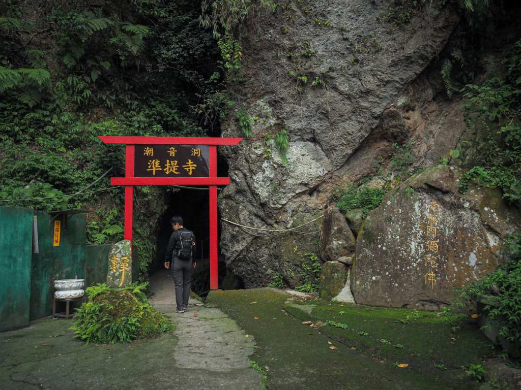
Once you pass the buildings, you’ll find yourself in a concreted space in front of the entrance to Chaoyin Cave Temple.


A short walkway snakes through a narrow slot with the top open to the sky. A channel runs to one side of the path, and after rainy days, the channel fills with flowing water.

The cave at the innermost reaches has two altars. Guanyin is the deity enshrined here, with both altars bearing different forms of Guanyin, one is a golden idol with many arms and the other is a simple dark wooden affair. There were two gentlemen in the cave sat on little meditation kneelers and facing the wooden idol. One was meditating, the other, scrolling on his phone.


Heading back out of the cave, we took the steep steps leading away and up from the concreted area. Once they draw almost parallel with a higher road, turn left and head towards the back of another small temple.

While small, this one had a couple of distinguishing features. For a start, a pair of huge and gold-painted rocks sat in the forecourt, but after peeking inside, I noticed the idol was also a rock (or maybe rocks) dressed up with a robe. The interior censor is also particularly lovely. The detailing on the two flanking lions seems somehow different to usual.


From the temple, the road splits in two. Take the righthand one heading up and follow it on a steep and winding course up and over the crest of a hill to Wuji Dongming Temple (無極東明宮).


It was late afternoon by the time we arrived here, so the temple had already been shuttered. We both topped our bottles up from the temple’s water dispenser before continuing on our way.


Speaking of which, there are no obvious signs to direct you out of the temple forecourt (although there are a couple of less obvious ones, including a triangle above an arrow which I think is meant to indicate the direction towards trig point for one of the nearby peaks). Head up the lane to the left of a metal parking shelter. Take another left onto a short flight of steps, then another left once you rejoin the main trail.

The following ten minutes is a steep and tiring climb up first stone, and then plastic wood steps. (If you prefer, there’s a dirt trail that runs parallel to this.)

We passed the twin Chaoyin No. 1 and No. 2 Peaks without registering or slowing, then followed the main stone path past turn-offs for Guanyin Northern Cross Trail and one of the exciting rope scrambles (both on the right).

By this time, it was getting on for four thirty, which in January can be a little gloomy, so this burst of bright pink blossom was rather cheering.


At the junction, we turned right and followed the steps all the way back down to where we started. (The trail on the left here is the one that I mentioned would be a shortcut from earlier.)
How to get there
Google Maps address: The walk starts from behind Lingyun Monastery. There is a carpark in front of the temple and plenty of road parking on the road too.
GPS location: N25 07.700 E121 25.450
Public transport: The O20 Extended Tourist Shuttle service departs from Luzhou MRT Station (by exit 1) roughly every 40 minutes. You’ll need to ride it for about 25 minutes and alight at Lingyun Temple bus stop.
Nearby trails:
Yingzai Peak and Chaoyin Cave Temple Trail Map
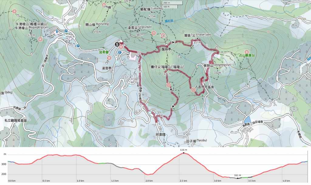
GPX file available here on Outdoor Active. (Account needed, but the free one works just fine.)
