RAKNUS SELU TRAIL – SECTIONS RSA58.2 – RSA60
Day 14 was my final day hiking on the Raknus Selu Trail’s main A route. As is often the case with such endeavours, it felt strangely anticlimactic to shuffle into town at the end of the walk with nothing but a silent, personal note of achievement ringing in my ears. “Huh?! So that’s it then?”
That said, the trail did save a wonderful surprise for us — we were treated to our first ever sighting of a Chinese pangolin. These adorable little creatures are listed as being critically endangered, but thanks to education and conservation efforts, their population in Taiwan is stable and increasing in number, so hopefully it won’t be our last sighting.
RAKNUS SELU STAMPS: The trail stamp for RSA59 is kept at Yong’an Temple aka the Carp Bogong Temple (永安宮/鯉魚伯公廟).
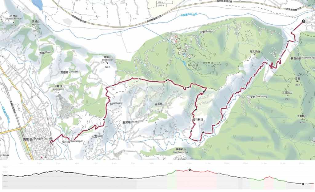
DISTANCE: 16.6 kilometres with the option to extend it by a (steep) kilometre if you’re a glutton for punishment and want to add in a side trip to Mount Anbuping
TIME: 5½ – 6½ hours — We walked it in about six hours at a slow pace.
TOTAL ASCENT: About 430 metres.
DIFFICULTY (REGULAR TAIWAN HIKERS): 4/10 — For someone familiar with Taiwan’s trails, this should be a relatively easy walk, but the length (and maybe the fact that we added an extra climb) made it feel harder.
DIFFICULTY (NEW HIKERS): 6/10 — As long as you’ve got reasonably good stamina, there’s nothing too challenging about this walk. The hardest elements for folks new to hiking in Taiwan will likely be overcoming any fear you may have of barking dogs and (in one or two places) figuring out where the path goes.
FOOD, DRINKS & PIT STOPS: We drank about 1L each on a cool December day and I was constantly snacking. The village of Shuangqi has a breakfast store and a couple of very basic roadside convenience stores. I think you can also get bottled drinks and at Sanchakeng, but you’d be best off making sure you have the food you need before setting off.
TRAIL SURFACES: Rural roads, farm tracks, farmland, and dirt trails.
SHADE: Much of this route is exposed to the sun.
MOBILE NETWORK: Mobile coverage was generally OK with a just few weak spots.
SOLO HIKE-ABILITY: As long as you’re confident facing down farm dogs, you’ll be fine. We encountered lots of noisy dogs, almost all of which were amenable to Teresa’s wiles and none of which caused us any genuine worry.
SECTIONS COVERED:
- RSA58.2: Miaoli District Road 58 → Baibufan Bridge → Shuangqi → Xiachuanlong → Chuanwu Ai Yong Historic Trail Trailhead (苗58→白布帆大橋→雙崎 → 下穿龍 → 穿霧隘勇古道口)
- RSA59: Chuanwu Ai Yong Historic Trail (穿霧隘勇線)
- RSA60: Chuanwu Ai Yong Historic Trail → Xiaozhongke Trail → Dongshi Hakka Cultural Park (穿霧隘勇古道 → 小中嵙步道 → 東勢客家文化園區)
Jump to the bottom of this post for a trail map and GPX file and all the other practicalities.
DIRECTIONS:

We were woken from a comfortable sleep by the sound of breakfast being cooked and a steady stream of patrons making their orders. Our accommodation just so happened to be the village’s one and only breakfast shop, and it seemed as if the cool winter morning had enticed the whole village in search of a hot breakfast. Rather delightfully, the proprietress insists on a “shoes off in the store” policy, so as school kids and labourers and the village police chief’s father made their way in to order danbing, toast, and hot milk tea, the pile of shoes by the door grew ever higher. Breakfast was included in the cost of our stay, so we ordered and ate as we watched village life unfold around us.
A sign in the shop says that the owner, a Paiwan woman who moved here from Pingtung opened the shop because when she first arrived in Shuangqi, she realised many kids were going to school without breakfast and she wanted to change that — it seems she must have been successful in her goal because the whole tribe’s kids were there shouting their breakfast orders through the external window or standing on tiptoes to order at the counter.

As we were leaving and putting on our hiking boots, an older woman stopped by and insisted Teresa go inside to help her order because she couldn’t be bothered to move her shoes, while on the street outside, village dogs embarked on their morning patrols. (The pink curtains and chairs on the right had been put out as part of some funeral activities for a recently passed community member.)

Leaving the village, we headed down to cross over Guanyinkeng Creek before starting to climb again.


Leftover water caltrops from the day before powered my ascent through kilometre after kilometre of orchards. At one point, we tried a detour to follow the ridge from Mount Weiwenkeng (尾文坑山), but we got turned around and ended up heading back down to the road instead.


Most of the orchards along the road were full of orange trees, but a few others had plums, peaches, and pears. The blossom here looks like it’s probably plum and elsewhere, we saw white (maybe) pear blossom.

The absolute highlight of the day (and perhaps one of the top highlights of walking the whole Raknus Selu Trail) was seeing a young pangolin beside the road.
We encountered it just as we were approaching a bridge and despite attempts to get it off the road before it reached the bridge, it insisted on toddling straight over, so we ended up escorting it all the way to the far side and sticking with it until it made its way to the safety of a patch of grassland. It was amazing to finally see one in the flesh and there were a couple of things about the encounter that stood out to me. I was surprised by just how terrible its eyesight was — it walked into things and stumbled over drains. I was also surprised by how utterly fearless they appear to be of humans, although perhaps that’s a consequence of their poor vision. And it was also really neat to see how perfectly designed they are for walking on scruffy hillsides like the one in the above video (as opposed to walking on a flat road surface).

After sticking with Dongqi Road for about 7 kilometres, it was finally time to take a right turn and begin our ascent to the orchards and ridgeline portion of the day’s walk.


Part-way up, a chap on an old Sanyang Yelang bike — one with gears to make the steep climbs easier. He tried really hard to convince us that there was no route up ahead, telling us that he was a local, so he should know. We did what we could to reassure him, pointing out the RST signage along the way and letting him know we were following a map, but he would not be appeased. In the end, he said that if we were sure we wanted to keep walking, it wouldn’t hurt to go up and take a look but we ought to “mentally prepare ourselves” for a tough walk. It isn’t the first time that I’ve met a local with no knowledge of the RST in their area, but he was so adamant that I started to have misgivings, especially since we’d already found our way blocked at the top of an earlier attempt to access the ridge trail.
Still, we kept heading up. There are lots of forks in the road along this stretch, so we really needed to pay close attention to the trail tags. Right/straight on in the above righthand photo.


Most of the time it’s easy enough to figure out which road to take purely based on which one looks more traversed, but that doesn’t always work. In the lefthand photo, the route takes the left fork, and in the righthand photo, the route heads right. This was the final junction before we reached the ridgeline.

Looking back down the trail to where a black dog was half-heartedly guarding a storage building. We were barked at, but the pup soon acquiesced to Teresa’s demands for it to “come here, be quiet and sit down”.

A little further up, we met an even more useless guard dog. This one was positively ecstatic to see us and — despite missing one of its hind paws — it indulged in some crazy zoomies, scooting backwards and forwards between us and its home.
When I meet dogs like this, who are still so ridiculously sweet-natured despite being treated as little more than farm tools by the people who keep them, I am struck by how utterly underserving we are of their affections.

When we hit the treeline, it initially seemed as if our pessimistic farmer friend was right. Aside from the not-to-obvious yellow diamond of the RST signage, it wasn’t clear that there was any kind of path here, and even scrambling up to join the tail proved a little tough. This is the start of Chuanwu Ai Yong Historic Trail.

However, after turning right and walking for a couple of metres, my fears were eased when we found this well-defined bamboo-lined trail leading through the forest.

It was clear that few people come through this way, because I was walking into spider web after spider web, but still — there was a trail and it was nowhere near as rough as we’d been led to believe.

After a particularly steep scramble, the woods spat us out near to the concrete base of an electricity pylon, which we had to scramble under.

On the far side, we could see the orchard-covered landscape stretching out ahead of us.

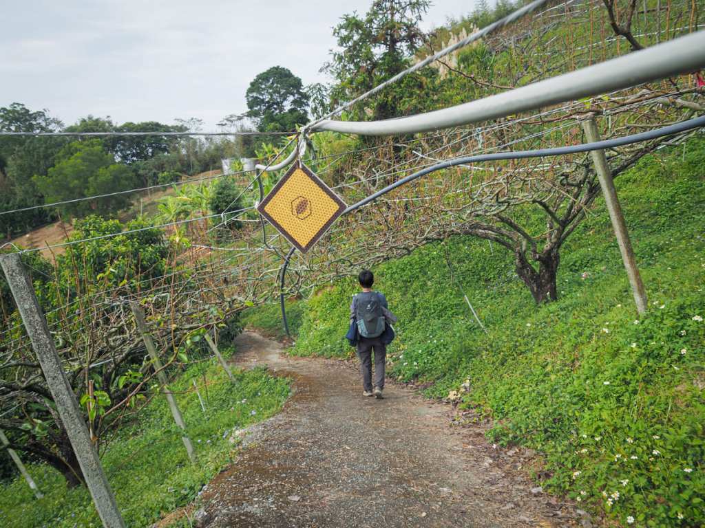
Speaking of orchards, when the ridge trail wasn’t taking us through scrubby woodland, it was leading us through the orchards. The farmers had strung up a latticework of wires and poles to train the trees into a low, creeping canopy. It presumably makes picking fruit easier, but it did mean that we frequently found ourselves having to duck down as we were walking.

As well as lots of peach and pear trees, we also passed banana palms and rows of dragon fruit plants draped over trestles.


Interspersed between the orchards were patches of trail, and in some places, the farms were either organic or abandoned as the trail was full of thigh-high wildflowers.

It looks like this region was perhaps more popular in the past, because here and there, we found the remnants of viewing platforms and trails. From the top of this platform, it was just about possible to make out our destination.


Wooden steps lead down from the platform and we were nearly tricked into following them. However, after a second more careful look, we spotted the RST signs directing us to the right and past another abandoned platform — this one with cute fruit characters.

After an hour spent traipsing through orchards and spider webs, we finally found ourselves following a concrete farm track.

The track climbed briefly to crest a hill before sloping gently down through more farmland.


At the end of the track, turn left onto Shilin Street (勢林街) and pass Hongjue Temple (宏覺寺) before taking the next left up another single-lane track.

I have to admit that by this point, I was ready for a nice sit down. My calves were starting to feel sore (likely as a result of the extra climb we did right at the start of the day), and my usually comfortable shoes had developed hot spots. Taking pauses to admire the landscape was doing little to ease the pain.


Where the road makes a sharp bend, the RST heads straight over and up before running into a dead end. When you hit the dead end, it’s time to get climbing.


A steep 100-metre scramble through bamboo brings you to another farm track. Turn left here and follow the track until it disappears into the tree-line again behind some water tanks.

By this point, Dongshi was starting to look tantalisingly close.

The final portion of trail was a pretty stretch of bamboo forest, although I was feeling a little too tired to enjoy it by this point.


The trail concludes at a large hilltop exercise and seating area, which appears to be popular with locals looking for a quick workout — we encountered maybe a dozen or so people making their way up or down to thhis spot.

In the pavilion, there were a handful of metal hula hoops as well as a couple of these heavy strings of wooden beads which Teresa says are meant to be pulled over your shoulders as a kind of massage tool. I don’t know if it was just because it was nice to take my pack off, but the massaging really did feel great.

A steep track and steps lead down from the exercise area.


When we reached a T-junction, we headed left, then at the next junction we took a right. Signage was somewhat lacking once we got down to thiis point, but it was easy enough to just keep heading towards civilization.


When we reached Xiaozhongxi Fude Temple (小中嵙福德祠), we both paused — Teresa to tend to the demands of a customer and me to swap out my hiking boots for flip flops.

The road eventually led us over Shalian River and — once on the far side — we turned right to walk towards the sunset and Dongshi.

The walk concluded at Dongshi Hakka Cultural Park but unfortunately, the park is closed on Mondays, so we didn’t check it out.


I picked up the final passport stamp from Yong’an Temple aka the Carp Bogong Temple (永安宮/鯉魚伯公廟), a strange and beautiful land god temple on the banks of Dajia River.


To celebrate completing the walk, we headed to one of the town’s vegetarian restaurants where we feasted on fried rice, triangular stuffed tangyuan and warming soup.
GETTING THERE
Public transport:
- Getting to Shuangqi — The 253 service runs between Dongshi Bus Station and Shuangqi Village about six times a day with the earliest services leaving Dongshi at 6:30am and 9:30am (arriving in Shuangqi at about 7am and 10am, respectively). To get to Dongshi Bus Station, you’ll need to hop on one of the many services (see below for bus numbers) that run from Fengyuan Transfer Station to Dongshi.
- Getting back from Dongshi — Lots of buses (90, 206, 207, 208) shuttle backwards and forwards between Dongshi Bus Station and Fengyuan Transfer Station. Once you’ve reached Fengyuan, you can hop on a TRA train to wherever you need to be.
Accommodation:
Accommodation in Shuangqi — There are a couple of places to stay in Shuangqi. We stayed in a breakfast shop that doubles as a B&B, which turned out to be very comfortable. The place has a single room that can sleep up to four.
- Name in Chinese: 芭勒的
- Address: No. 89號, Section 2, Dongqi Rd, Shuangqi, Heping District, Taichung City
- Contact: 0905630261
- Cost: I paid $2,300 including breakfast. The cost feels a little steep for two people but if your group fills the room, it’s much more reasonable.
Accommodation in Dongshi – We went straight home instead of staying Dongshi, but if you’re looking to stay in the area, looking for somewhere in Fengyuan is probably your best bet.
RAKNUS SELU DAY 14 TRAIL MAP
GPX file available here on Outdoor Active. (Account needed, but the free one works just fine.)
