
One of the reasons why I wanted to come to Kinmen in the first place was so that we could climb Mount Taiwu. This 253m high peak is the ninety-ninth of Taiwan’s Xiao Bai Yue, and the highest point in the whole of Kinmen. By the time we got around to walking it, we’d already been in Kinmen for about a week, and had circled the island’s rocky spine several times. From Jinsha and Jinhu Townships, it’s an especially commanding feature of the landscape, its pale granite flanks are visible from pretty much wherever you go.
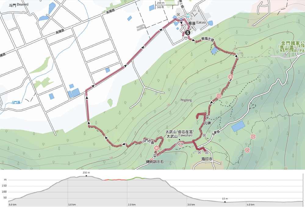
DISTANCE: 5 kilometres.
TIME: 1½-2½ hours – We landed somewhere in the middle of this time from and were not speed-walking.
TOTAL ASCENT: About 220 metres.
DIFFICULTY (REGULAR TAIWAN HIKERS): 2-3/10 – For those with experience of Taiwan’s trails, this should be a relatively easy hike
DIFFICULTY (NEW HIKERS): 3-4/10 – This would be an easy-moderate hike for those new to hiking in Taiwan.
SIGNAGE: The signage is OK but not great, and you won’t find any signage at all directing you to the true summit (for that you need to look out for hiking tags).
FOOD AND WATER: We took 0.5L each. There’s also a coffee shop near Haiyin Temple.
SHADE: Most of this walk is quite exposed to the sun. We went in the late afternoon, so no sun protection was required, but I would have been more careful earlier in the day.
MOBILE NETWORK: Pretty clear throughout.
ENJOYMENT: As the tallest summit in Kinmen County, this peak is well worth a visit if you’re in the area. It has good views of the surrounding landscape and has some points of cultural interest too.
SOLO HIKE-ABILITY: Generally fine for solo hiking.
OTHER: I am not entirely clear as to the legality of visiting the true summit. It’s clear that some hikers do, but it’s also clear that the majority of walkers skip it and just stick to the main paths.
TAIWAN 100 MINOR PEAKS: Number 99, Mount Taiwu
ROUTE TYPE: Loop
PERMIT: None needed
Jump to the bottom of this post for a trail map and GPX file.
DIRECTIONS:
Numbers by photos refer to the GPS coordinates at the end of the post.

There are multiple paths that will get you up to the top of Mount Taiwu, but we picked what looked to be the most interesting of the bunch: a loop starting from the village of Caicuo, climbing up Caicuo Historic Trail (also referred to as Baierjie Historic Trail), and leading back down via Doumen Historic Trail.

The path starts easily enough with undulating steps leading you gently upwards.

t didn’t take long for the first view of the walk to present itself. Immediately below us was Caicuo, where we’d started the walk, then a little further away was the more built-up area of Jinsha.


About ten minutes after we started our walk, we reached Yuanlu Lake. Despite the sign warning hikers of deep water, the lake was barely more than a puddle. It didn’t rain at all during our ten-day visit, and considering that Kinmen is famous for cultivating peanuts, millet, taro, and sweet potatoes (all crops that do well in extremely dry conditions), it’s likely a rarity to see it full.

Beyond the lake, the trail climbs a little more to a grassy area, then diverts to the right up more steps.


It was around here that we encountered a group of giggling National Quemoy University students who told us not to bother climbing the rest of the way. They said we’d already walked 700m, and that the top was cold. When it became obvious that we weren’t going to take their advice, they gave us a parting “加油!” and continued on their way down.

It’s a good job we didn’t listen because the best views of the walk were just beginning.

From up here it is striking just how close Kinmen is to the coast of China. With powerful binoculars you could make out individual cars moving on the streets.


Half an hour after we started our climb, we found ourselves up on Mount Taiwu’s rocky ridge. It’s mostly quite clear where to go, and for the times when the path seems to disappear, just look for the spray-painted arrows directing you onwards.

To the right of the trail, a huge boulder bears the barely visible traces of a Yuan dynasty inscription. I could hardly see the characters myself, but what drew my attention to the rock was the rock-filled crack with a tree growing from it. The inscription was rediscovered in 2007 when a pair of local historians were exploring the area, but the carvings are old. They date back to 1363 and were left to commemorate the fact that Chen Yuanze commissioned and funded the construction of a fort and paving of a road. For those who can read Chinese, this is what the engraving says:
「忠翊校尉浯洲場鹽司令陳元澤,募緣築造山寨、鋪砌石路。董役司令謝忠南、司丞王國禮、管勾呂務能、耆儒陳志霖、僧王岩、司吏李榮。至正癸卯二十三年春三月謹誌」
Plans were mooted to make the words more legible by adding some paint, but thankfully it managed to avoid being “beautified” and has instead been preserved as a historic monument.
Now there’s going to be a bit of jumping around in the timeline, because we didn’t realise that this is where the rougher trail to the secondary summit of Mount Taiwu can be found, so we actually returned to this spot after first having watched sunset from close to the Pagoda of Reflection. If you look around to the side of that smaller section of the boulder on the right, you will find a narrow track taking you further up the hill.

There are indications that it used to be blocked off (razor wire beside the trail), but no signs prohibiting entry, and other hikers have attached red ribbons and bottles to the wire to try and prevent people from walking into it.


After a couple of minutes, the path splits. The right fork goes to a military bunker of some kind, while the left makes its way to the peak. The very final few metres involve a scramble and some ropes.

It took no more than four minutes to climb from the Yuan Inscription, and it felt incredibly satisfying to reach the peak. The actual peak appears (on topographical maps at least) to be located somewhere further along the trail in a spot that is very much blocked off for military purposes, but at least we were able to find this replacement summit marker. Since it was getting dark, we didn’t linger long, and soon made our way back to the trail and continued our journey.

And now we’re back to the pre-sunset photos. From the Yuan Inscription, the trail heads down into a forested valley.

Before you dip down as far as the wooden bridge, there’s a view of the antenna dome on the slopes above Haiyin Temple.

At the far side of the bridge, the steps start to climb again before depositing you on a pedestrian road. The route that we took continued straight up from here, but first we headed left to get a coffee and have a nosy around the temple.
Well… I say we, but in fact, Teresa went off to buy (very nice, but expensive) coffee from a man with a pet bulbul named 泡菜 (Kimchi) who chirruped and fluffed every time his name was spoken, and I went to have a look at the temple.


The history of Haiyin Temple is even older than the nearby Yuan Inscription. According to local authorities, its establishment can be traced back to the mid-1200s, and it claims to be one of very few temples in Taiwan that can trace its origins to the Song dynasty. It seems there is some disagreement as to who the temple was originally dedicated to, Leshan Wang and (樂山王) and Tongyuan Xianweng (通遠仙翁) both being put forward in different places (or perhaps these are two names for the same figure, that happens sometimes). Either way, it was originally a Taoist temple, but worshippers later converted it to a Buddhist one after witnessing the manifestation of Guanyin. Unsurprisingly given its age and location in an area that has been the site of much fighting, the temple has undergone numerous bouts of renovation over the years.
Haiyin Temple is spread over several levels, with the first one you come to being the Guanyin Hall. Just about and behind that is the Anxin Rock Hall. The rock was found during the construction of the temple, and allegedly people touch the stone with their right hand while placing their left hand on their chest and reciting “南無大慈大悲觀世音菩薩” three times are rewarded with a great sense of peace in their hearts.

Up behind the Anxin Rock Hall is the temple’s main Hall. Here you will find a large, gold Buddha sitting in peaceful reflection. There are also sculpture gardens and a few other nooks to explore, but I figured that Teresa would probably be looking for me, so I headed back down to find her.

From Haiyin Temple, we made our way up the road, passing the Wu Wang Zai Ju Inscription. Kinmen, it would seem, loves a good inscription. They’re everywhere! This one is a particularly popular one, and had a huge crowd gathered to take photos in front of it. The phrase, 毋忘在莒 was carved into the cliff on the orders of Chiang Kai-shek in 1952, and has been translated by the local government to mean “Never Forget National Humiliation”. It was intended as both reminder and motivation to those soldiers on the frontline. While I have some sense of its significance, I cannot quite square in my mind why this has become one of the top sightseeing spots for Taiwanese tourists visiting Kinmen. What are you supposed to feel when you pose and smile in front of these characters?


A short way beyond the Wu Wang Zai Ju Inscription, the road starts to dip down again. Look out for this turning on the right which will lead you towards the Pagoda of Reflection (named Daoying Ta on most of the signage).

Like the Wentai Pagoda, which we saw on an earlier wander in Jincheng Township, this structure was built during the Song dynasty (960 to 1279), although the version of it you can see today was built in the 1990s because the original had long ago collapsed.

Sunset from this spot was pretty, but like the sunrise we saw the following morning, it was quite hazy. The above photo was taken shortly after the sun had been doused by the sea.


Below the pagoda and right by the observation platform, there is a natural cave-cum-tunnel that must be a delight to sit in on a hot summer afternoon. There is an obvious chill, and the dual openings cause a breeze to run through it. According to local legend, this is where Koxinga came to play chess when he wasn’t organising the troops.

By the time we returned to the pavilion and viewing platform after having found the summit of Mount Taiwu, the sky had filled darkened. We decided to loop back to our starting point by taking Doumen Trail. This leads down in front of the Pagoda of Reflection’s northern side.

It was proper dark by this point, and somehow, despite having brought our head torches to Kinmen, and despite knowing that we were planning to walk down after sunset, we’d both stupidly left them in the suitcase. Luckily, our phones were up to the job (although there’s no doubt that it would have been better to have hands-free lights during the first stretch).


Once the trail became steps, it was a lot easier to see where to put your feet. There weren’t really any junctions either, so it was easy not to go astray. The only place where we had to double-check the route is at the spot in the right photo. A wooden walkway extends to the right, but the trail continues to head straight down and through some trees. We paused a little further down from here in a clearing with a small grave and turned our lights off to look at the stars. By a stroke of luck, just as we were looking up, we saw a shooting star–Teresa’s very first one! I think it was probably part of the Leonid meteor shower, which peaked the day before.


About half an hour after we left the Pagoda of Reflection, we found ourselves back on the flat. From the trailhead, we walked up to the narrow backroad and turned right to head towards Caicuo and our scooter. The hedgerows were bristling with life, shrews, birds, frogs, and…

…just before we turned right to head back to where we’d parked our scooter, we saw an actual Burmese python! At first, I assumed that this must be an introduced species, but actually, these pythons are native to Kinmen. These giants of the snake world were once considered a delicacy among the soldiers stationed here, and that combined with the fact that Kinmen saw active fighting led to a steep drop in their numbers, but it would seem that they’ve bounced back, and are now quite a common sight when the weather starts to dip in the evening. It felt like such a treat to catch a glimpse of this beauty.
HOW TO GET TO MOUNT TAIWU
Google Maps address: We started our walk from the visitor centre at the back of Caicuo Village, walked down to the start of the Doumen trailhead, then walked back along the road to pick up the scooter.
GPS location:
- Caicuo Village trailhead – N24 28.290 E118 25.005
- The summit of Mount Taiwu – N24 27.925 E118 25.060
- Doumen trailhead – N24 27.875 E118 24.510
Public transport: The closest bus to the trailhead is Caicuo Wind Lion God, but that is only served by two buses daily — the Taiwan Tourist Shuttle E route departing Shanwai Bus Station at 8:25am and 1:25pm. Because of this, it would probably be easier to get to the slightly further away (like an extra couple of hundred metres) Caicuo bus stop and walk through the village. The 18A shuttles between Shanwai Bus Station and Caicuo roughly once an hour between the hours of 8am and 7pm and the journey takes about 20 minutes. You can catch buses from all around the island to Shanwai.
Further reading: Here is an article about the climb written by Richard Saunders (of Off the Beaten Track fame) for the Taipei Times.
MOUNT TAIWU TRAIL MAP
GPX file available here on Outdoor Active. (Account needed, but the free one works just fine.)
