Tashan, the Highest of Taiwan’s 100 Minor Peaks
The observant amongst you might have noticed that within the heading and subheading of this route guide, I have already used two different names for the mountain in question. That is because this peak has multiple names in Chinese (and other languages). The name which appears on most maps is Mount Data (大塔山), Big Ta Mountain if we’re translating word for word, and Big Tashan, according to some. However, the name people seem to prefer is Ta Shan or Mount Ta (塔山). The confusion here probably stems from the fact that there is Big Ta Mountain and a Small Ta Mountain (小塔山 or Mount Xiaota), and these two (along with several other nearby peaks) are collectively called the Ta Mountain Range (塔山系). In addition to these two names, it is known as Hocobu (also written as Hohcʉbʉ) in the language of the Tsou—the indigenous people who live in Alishan Township. Finally, I have also seen it called Mount Daito (or sometimes Daitou), which I think must be a hangover from the Japanese name for it—after all, Alishan was first developed as a foresty (and later recreation) area by the Japanese during the Japanese colonial era.
Naming conventions aside, this area is sacred for the people of the Tsou tribe. They believe that the souls of their ancestors flock to these hills after death, with the souls of good people gathered on Mount Data, while evil-doers get relegated to Mount Xiaota. It is also a fine walk and a pleasant way to spend half a day, and also one of the quieter hikes you can do within Alishan National Forest Recreation Area.
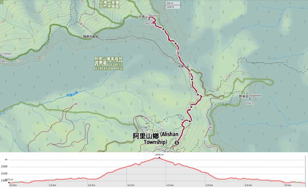
DISTANCE: About 7.6km.
TIME: It took me almost exactly three hours to walk this at a normal pace for me. I think it would be safer to budget a little more time than that though.
TOTAL ASCENT: About 360 metres.
DIFFICULTY (REGULAR TAIWAN HIKERS): 3-4/10 – This belongs on the hard end of easy for a regular hiker in Taiwan based on the elevation gain and steepness. (Although I think my already-tired legs might have biased me a bit.)
DIFFICULTY (NEW HIKERS): 5-6/10 – The steepness, length, and amount of elevation gain would make this tiring for someone new to hiking in Taiwan, particularly when compared to the other trails within Alishan National Scenic Area. That said, it is just tiring, not dangerous, so as long as you’re in generally good shape, have supplies, and give yourself plenty of time, there’s nothing to stop you giving this peak a go.
SIGNAGE: Clear signage throughout.
FOOD AND WATER: I took about 1L (some of which was in the form of coffee) and snacks.
SHADE: The first section of the walk is very shady; the final third is not.
MOBILE NETWORK: There are one or two signal dark spots, but mostly very clear.
ENJOYMENT: This is a really great walk. The scenery is beautiful and varied, and the views from the peak are excellent.
SOLO HIKE-ABILITY: There’s no reason why you couldn’t do this hike alone. That said, its location within a national park means that you’re unlikely to be alone, even if you hike solo.
OTHER: If you pick your weather carefully, it’s possible to watch the sunrise from the observation platform at the top of Mount Data (just make sure you pack a headtorch if this is your plan).
BATHROOM FACILITIES: There are toilets at Chaoping Station, but none after that.
TAIWAN 100 MINOR PEAKS: Number 59, Mount Data (大塔山), also known as Ta Shan. At 2,663 metres above sea level, this is the tallest of Taiwan’s Xiao Bai Yue.
ROUTE TYPE: There and back.
PERMIT: None needed, but you do need a ticket to enter the park. (Details below.)
Jump to the bottom of this post for a trail map, GPX file, and transportation information.
DIRECTIONS:


Once you’ve entered Alishan National Scenic Area, make your way to Chaoping Station. It’s about a 20-minute walk from the ticket gates, and along the way, you’ll pass a 7-Eleven where you can pick up provisions. Chaoping Station has a water dispenser where you can fill up your bottle, and it’s also the last place with a toilet block for the rest of the walk. (I’d brought my notebook with me, so I popped into the station to collect the station stamps before heading off.)


From the station, follow the tracks up past Alishan Gou Hotel and towards the start of the Sisters Ponds Trail. Some people take a shortcut along the tracks here, but there are signs warning you not to.

Where the Sisters Ponds Trail veers away from the tracks, steps head down past a selection of wooden sculptures designed to give information about the logging industry. The style is bold, blocky and beautifully suited to the surroundings.


Follow the steps down through a wishbone arch formed from the roots of a long-ago-felled cypress, past a side trail joining from the left, and down to this next junction presided over by a multi-generational tree (the original trunk was cut down by loggers, but a new one grew up on top of the stump). The pillars at the bottom of the steps reveal this to be the start of the Mount Data Trail. Turn right here and begin the climb.

The steps soon take you back up to the railway line, which can be crossed via this footbridge. The last time I visited Alishan was with my parents. We made a journey up here so my dad could enjoy seeing one of the steam trains in action, and this bridge was a prime train-viewing spot for the kind of enthusiasts who follow trains around toting big lenses.


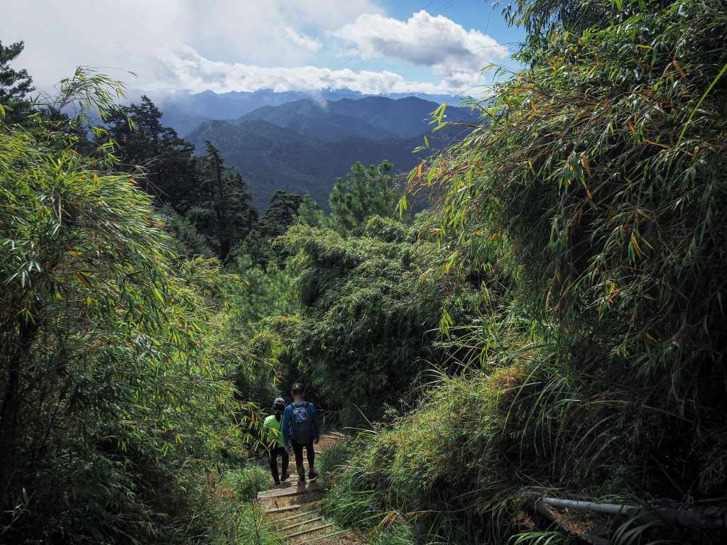
This next section of the trail is both beautiful and very pleasant. Since it mostly sticks close to the tracks, there is little change in elevation, which means you’re free to enjoy the forest scenery without huffing and puffing.

At times, the trail runs literally right beside the tracks, and at other, the two are separated by a narrow bank of trees.

Some hikers choose to walk along the flatter rails for this section. Technically, it is prohibited, however, unless there’s a special activity (such as the steam train rides we joined last time), the last train of the day to pass through here is long gone by 8am, so it’s not really a rule that’s enforced


A bridge over the tracks marks the point at which the rails up to Duigaoyue Station (the one people head up to when they go to see the sunrise) depart from the now-unused Mianyue Line. This little hut is where the Shizifendao Station (十字分道站) used to be. (Originally, I had hoped to walk the Mianyue Line on this trip to Chiayi, but was thwarted by the need for at least three people in your group—even if Teresa had come with me, we wouldn’t have been able to go it alone.)
A little way beyond the bridge, the steps lead down to a kind of staging area which is the official start of the Mianyue Line Trail. Lots of signs make it clear that the route along the tracks from here on out requires a permit, and one announces the number of fatalities and accidents that the trail has had in the past year. The Mount Data Trail leaves this area via the flight of steps in the far righthand corner from where this righthand photo is taken.

A pile of rusting cans—perhaps they once contained oil for the railway. One interesting element of Taiwan’s national scenic areas (many, if not all of which are former logging sites) is that they often still have the detritus of past industry just left lying around for people to see. You could say it’s just rubbish, but there’s another argument which says that removing it would be denying people the chance to understand the forces that shaped the way the landscape around them was formed.


Tree-based art: one natural, one… less so.

The chap in the photo here was walking the trail in flip-flops. We arrived at the top around the same time, and when someone questioned him about his choice of footwear, he proudly declared that they are the most comfortable shoes for almost any activity, and that he has also run a marathon in them.


Although the vast majority of the climb is done under the cover of trees, towards the final third, the plant mix changes and there are frequent breaks in the tree cover where you can catch glimpses of the scenery beyond. The big structure on the left is Alishan Hotel, the middle scattering of lower buildings is one of the staff dormitory areas, and the larger collection of buildings on the right is the assortment of stores and hotels close to Alishan Station and the bus drop area.

Despite the elevation, the combination of sun and exertion made this part of the climb quite warm.

It was also the part of the walk with some of the best long-range views.


When you see these concrete steps, you’ve only got another couple of hundred metres left to go. Make sure to pause and look back as the steps turn to the left—this is the first time you get a mostly unobscured view of the mountains to the east.

Just below the summit, there is an old building (perhaps a weather observation station) that seems to have been decommissioned, save for a bank of solar panels that have been installed on the roof.

At 2,663 metres above sea level, Mount Data is the highest of all the 100 Minor Peaks.


That said, the trail does not actually take you all the way to the summit. The true summit is that sticking up section of rock just right of centre in the above-left photo. It’s not possible to scale the summit because the government has decided it is too dangerous and because the Tsou aboriginals who live in the region venerate it as a sacred mountain—home to the souls of righteous deceased ancestors. (Although I strongly suspect the first reason is the decisive one.)
I enjoyed a banana while looking at the view, watching a brazen white-whiskered laughingthrush steal crumbs, and having a chat with some of the others who’d ended up on the summit at the same time. From up here, you can see the summit of Jade Mountain… well, you can when the clouds decide to cooperate. On the day of my visit, Taiwan’s highest mountain remained just slightly obscured the whole time I was up there.

After about 15 minutes, I shouldered my pack and set off back down the same way I’d come.


Visually pleasing details observed on the way down—yellowed ferns and a patch of sunlight in the forest.

On the way back, I followed the tracks back as far as the first bridge, then took the trail back to Chaoping Station.
HOW TO GET TO ALISHAN NATIONAL SCENIC AREA
Google Maps address: The walk detailed in this post starts from Chaoping Station, which is within Alishan National Scenic Area. If you are planning to arrive here using your own transport, you’ll want to park along the stretch of roadside above the park.
GPS location: N23 30.850 E120 48.830
Public Transport to Alishan
Public transport: Given the park’s location, you’ll probably want to spend the night in the area even if you have your own transport. To get here on public transport there are a couple of options.
- Bus from Taipei – the 1835 Kuo-kuang bus departs Taipei Bus Station, although their website is unclear and doesn’t list any timetable, so you’re better off either calling (good luck) or going in to enquire about when that service operates.
- Bus from Chiayi – the 7322 Chiayi County bus leaves Chiayi Station (not the Chiayi HSR Station), whilst the 7329 departs from the HSR Station (not the regular train station). You can buy tickets for both of these from Famiport or iBon machines – again, just make sure you’re prepared in advance and know where you’re going.
- Train and bus from Chiayi – if it’s you’re first (and maybe only) time in the area you might want to consider riding the Alishan Forest Railway as far as Fenqihu and then transferring to bus for the remainder of the journey (hopefully the whole of the route will be repaired soon, but for now you can only go part of the way). This railway is a truly spectacular feat of engineering, and (assuming you don’t get motion sickness), it’s a journey well worth taking at least once in your life.
Alishan Park Entrance Tickets
There’s no need to pre-book Alishan tickets, you pay when you enter the park. If you have an APRC, student ID, Mountains to Ocean Greenway Passport, or the yellow ticket issued by bus operators to prove you travelled on public transportation, you can get a discount. When I visited, the cost was NT$300 for a standard ticket and NT$150 for a discount. You can check the park’s website for the current ticketing information.
Further reading: For all those people looking to squeeze more adventure into a small amount of free time, this crazy impressive guy left Taipei, visited this summit (and saw the sunrise from Ogasawa Viewing Deck AND summited Duigaoyue), and returned to Taipei within 24 hours. However, I wouldn’t recommend doing this unless you can sleep well on public transport and are generally well-rested (there’s also the fact that the marginally lower oxygen levels are noticeable if you’ve come straight up from sea level).
Nearby trails:
- Alishan Giant Tree Boardwalk Trail
- Alishan Sisters Ponds Loop
- Shuishan Sacred Tree Trail
MOUNT DATA TRAIL MAP
GPX file available here on Outdoor Active. (Account needed, but the free one works just fine.)
