
RSB01 – RSB02
It’s been so hot this summer. So, so hot. In previous years, I’ve been able to carry on pretty much as normal, just not so far or so long in the sun, but this year defeated me. So my Raknus Selu journey has been on hold. However, the temperatures have been creeping downwards since the start of October, and although it was still in the high twenties on the day of this walk, it feels pleasant compared to a few weeks ago. I decided to pick up my journey by walking the first two sections of the B route, starting from Longtan Lake and ending at the official start of the Raknus Selu Trail: Sankeng Old Street.
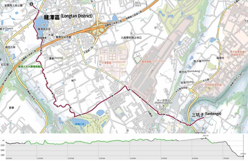
DISTANCE: About 7.5km. I ended up walking further due to a diversion, but I haven’t included that in the map or GPX file I’ve shared.
TIME: 2½-3½ hours on foot. You could do almost all of this route by bike, and that would be significantly quicker.
TOTAL ASCENT: Virtually none. This route is either flat or downhill the whole way.
DIFFICULTY 0.5/10 – Whether you’re new to Taiwan or have been hiking here for decades, there’s nothing difficult about this day’s walking.
FOOD, DRINKS & PIT STOPS: There are lots of places to get provisions close to where you’ll start this walk. You’ll also find lots of convenience stores and small restaurants around Zhongzheng Road (close to the Hakka Culture Museum. If you just want to fill up your water bottle, you can do that at Nantian Temple (close to the start), and I believe you should also be able to top up at the Hakka Culture Museum if you visit on a day when it’s open.
TRAIL SURFACES: Smooth, paved asphalt, aside from the one stretch of stone steps close to the end of the walk.
SHADE: There are long stretches of this walk where you’ll be exposed to the sun.
MOBILE NETWORK: Clear signal throughout.
SOLO HIKE-ABILITY: Solo hikers and bikers should be very safe on this portion of the route.
SECTIONS COVERED:
- RSB01 – Shengji Pavillion → Longtan Lake Bikeway → Taoyuan District Road 66 → County Road 113 (聖蹟亭→龍潭大餐自行車道→ 桃66→ 縣113)
- RSB02 – Tiaodan Historic Trail (百年挑擔古道)
Jump to the bottom of this post for a trail map, GPX file, trail map, and all the other practicalities.
DETAILS & DIRECTIONS:

The point chosen as the start of the Raknus Selu B routes is Longtan’s Shengji Pavilion (龍潭聖蹟亭) and it is a very interesting spot indeed.


“Shengji Pavilion” is not the name for this historical relic, rather, it is the name for a type of structure that used to be commonly found throughout Taiwan, particularly in Hakka settlements. They are sometimes also called Jingzi Pavilions (敬字亭) or Xizi Pavilions (惜字亭), but regardless of the name, the purpose they serve is as a ceremonial receptacle for burning used paper. This practise came about because of the immense respect that people used to have for the written word (or character, I suppose). It was believed to be unfitting to simply dispose of no-longer wanted written materials as you would normal rubbish, and so these furnaces and ceremonial practises were established as a way to show writing the respect it deserved.

These days, there are a handful of these pavilions still standing (in Zhongli, Daxi and Shulin for example), but Longtan’s is rare in that it still holds a ceremony on the 28th of March each year.


Longtan Shengji Pavilion was first built in 1875, then later rebuilt in 1925, and its construction is rife with symbolism. The lower of the structure’s three levels has eight sides evoking the bagua (八卦), which is beyond my pay grade to explain on a hiking site (essentially, it’s a philosophy or way or reading the world with a set of eight symbols at its core-or something to that effect). The four-sided middle layer represents the Four Symbols (four animals, both mystical and real that represent the four cardinal directions). And the six faces of the upper layer are a reference to the six directions (in Taoism, above and below are included in addition to the regular north, south, east and west).


From the pavilion, walk southeast on Shengting Road (yes, the road is named after the pavilion), and either walk straight until you see Longtan Lake, or turn right onto Provincial Highway 3 and follow it for a short distance until you see the lake.

Longtan Lake (龍潭大池) has its own mascot named Dragon Baby (龍寶). The mascot is based on a local legend which says that a yellow dragon can sometimes be spotted writhing beneath the shallow surface of the pool in particularly severe storms. I’m not sure if the statue it’s meant to be a bipedal version of said dragon or a kid in a dragon costume, but either way, it welcomes walkers with a large green hexagon bearing a squiggly white line, and if you’ve walked any of the Raknus Selu Trail already, this is instantly recognisable. It is one of the symbols used to mark the way.

From the lakeside decking just next to Dragon Baby, you can enjoy the pretty sight of Nantian Temple (桃園龍潭南天宮) reflected in the water.


To start my walk, I headed round to the path running along the lake’s western shore. There’s a coffee shop here and public toilets.

A shiny peacock sculpture faces the entrance to the long white bridge. I decided to cross over for a quick detour and take a quick look inside the temple. (I didn’t take any photos though, there were lots of people busy praying.)
Pretty scenery looking over to a pavilion on the far shore with Nan Chatian Shan (南插天山) rising behind it in the distance.

There is a small kids’ paddling pool partway along the lakeshore with a dragon-shaped slide. Since it’s already October, there was no longer any water in it, but I think it gets cleaned and filled at the start of the warm weather each year.


Some of the many turtles that reside in Longtan Lake.


Here you can either walk around the paddling pools, or over the wooden walkways. Both paths link up again close to the red brick Full Moon Bridge (滿月橋).

Once you reach the bridge, don’t cross over. Instead, take the cycle path running beside the waterway.

The waterway is pretty. There’s a row of houses almost backing onto the river and it feels very unlike Taiwan.


After passing through a channel under a small road but before passing under the roaring freeway, I startled a kingfish which zipped off to the far back in a flash of electric blue.


It’s only once you get beyond the freeway that the walk starts to settle into the more rural-agricultural scenery that is common to most of the Raknus Selu Trail.


Upon reaching a small park (龍潭大池水體環教園區), the trail takes a left turn to follow another stream. The park looks recently rebuilt. There are shallow pools for kids to paddle in, neatly designed toilet cubicles lit with natural light, and a large family grave.

More dragon symbolism, this time in the form of a bench.


For the next thirty minutes, I followed the meandering course of the stream through rice paddies and fields of almost blooming cosmos flowers. I chatted to a local jogger and he said that the government encourages farmers to leave their fields fallow for a number of years so as to not over-deplete the soil. One of the ways they can do that is by filling them with cosmos flowers (which at least bring in visitors who might buy your homemade snacks, even if you’re not able to grow rice). He said that November is the best time to visit and see them in full bloom.


I crossed a few roads and switched which side of the river I was walking on several times, but since the waterway is your guide, there’s no way to get lost.

A small fish pond by one of the hamlets I passed through.


At Minsheng Road, the waterside walkway comes to an end, and I turned left onto the road.

In normal times, you should be able to just keep following this cycle path past the entrance to the golf course and all the way to Fuhua Street. However, on the date of my visit, it was being dug up to be resurfaced, so I had to do a large detour.

Once you cross over Fuhua Street, keep following Minsheng Road as it curves right and enters a small community. Although there are lots of buildings, a large number of them on the right side of the road look like they’re on the verge of collapse.

A bright-eyed cat guarding some drying produce.


Once you hit the main drag of Zhongzheng Road, take a right turn. It’s best if you cross over and walk alongside the barbed-wire-topped fence of the airbase so that you can stare down all the passing motorists.


Murals of varies helicopter models beautified by tung blossom adorn the walls of the base.

A little further along Zhongzheng Road, you’ll pass the Taoyuan Hakka Cultural Centre. It’s closed on Mondays, so I wasn’t able to visit (except to pop in to use the toilets), but if you’re walking the Raknus Selu, you might find it interesting to learn more about the culture of the Hakka People.


Instead of visiting the museum, I did a short detour through the park. As well as having little Hakka statues welcoming you in, the park was full of features and signs explaining various aspects of Hakka like, such as the waterwheels and land god temples that are a common sight in Hakka villages. The signs were even partially written in Hakka.


At the far end of the park, I crossed over Minzu Road and took a sharp right turn down Shiyifen Road.


The road curves and heads downhill towards the odd dome on top of Shimen Junior High School. If you follow the road all the way down, you’ll soon find yourself crossing over Wenhua Road. Follow the red-brick-paved street past the elementary school and all the way to the end.

When you run out of street, you’ll find a flight of steps curving down to join Zhongzheng Road (it’s the same Zhongzheng Road as earlier, just a little further along). This trail, while it looks new, is actually a short section of historic trail. Locals and visiting traders used this route back in the days when goods used to arrive at Sankeng via boat


At the bottom of the steps, cross over Shimen Big Canal, then cross over Zhongzheng Road and follow Yongffu Road past a small temple and through a green archway.

After just another couple of minutes, the road arrives at the start of Sankeng Old Street, which is also the official start of the Raknus Selu Trail’s main route. I had a wander around the street (unfortunately, almost all the stalls were closed because I visited on a Monday), and popped into Yongfu Temple before retracing my steps back as far as the elementary school to wait for a bus.
GETTING THERE
The walk starts from Shengji Pavillion and ends at Sankeng Old Street.
Public transport:
- Getting to Longtan Lake – From Taipei Bus Station, take the 1820 or 1820A Kuo-gang bound for Leofoo Village. Even though the bus station has ticket counters, you can just can just tap in with your easy card when you board. Ride it for about an hour and alight at Zhongzheng Road bus stop (at the time of writing, this bus leaves from the fourth floor of the bus station). When you alight, you’ll need to cross over the road and walk the 10-15 minutes to Longtan Lake.
- Getting back from Sankeng Old Street – If you go on weekends, you should find a taxi ready to drive you back to Longtan’s central street. However, if you’re relying on public transport, you’ll probably have to retrace your steps as far as the elementary school on Shiyifen Road. You can catch either 5044, 5051 or 5055 bus from Shiyifen (Wenhua Rd. Live Fish St.) stop back to Zhongzheng Road, Beilong Intersection. From there, you can walk a minute along the road to the bus stop for the 1820 back to Taipei. It is worth noting that the 1820 services to and from Taipei both stop on the same side of the road, so make sure you check the destination on the front of the bus before boarding.
YouBikes: If you’re looking to do this section by bike, you can pick up a YouBike from Longtan Lake, return it outside the Hakka Culture Museum, and walk the remaining distance to Sankeng Old Street.
Accommodation: I walked this section just as a day hike, but we stayed in Sankeng while walking a different section.
Staying in Sankeng – Sankeng Laodie is about a 20-minute walk from Sankeng Old Street, and is pretty much on the Raknus Selu Trail’s primary route.
- Name in Chinese: 三坑老爹
- Address: 325桃園市龍潭區永昌路51巷18弄18號
- Contact: 034115350
- Facebook: @skld.034115350
- Cost $600-700 per person
RAKNUS SELU TRAIL MAP – B ROUTE SECTIONS 1 & 2
GPX file available here on Outdoor Active. (Account needed, but the free one works just fine.)
