
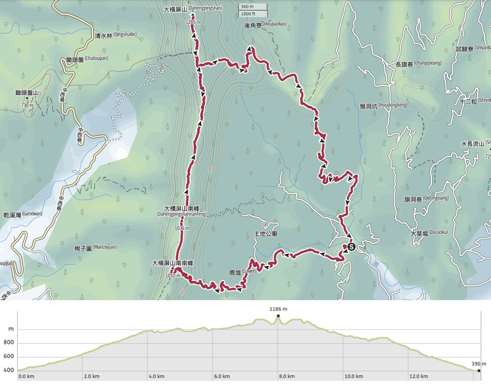
DISTANCE: 14.2km
TIME: 6-9 hours – We walked at a slower pace than most and stopped for several breaks and it took us about eight and a half hours.
TOTAL ASCENT: Over 1100 metres.
DIFFICULTY (REGULAR TAIWAN HIKERS): 4-5/10 – This is a physically tiring hike. There is lots of elevation gain (although the majority is done on roads), lots of scrambling, but the route is easy to follow.
DIFFICULTY (NEW HIKERS): 7-8/10 – Both the total amount of elevation gain/loss and the roughness of parts of the ridge would make this quite challenging (and probably unpleasant) for new hikers.
SIGNAGE: There’s signage at every junction, but it’s all Chinese-only.
FOOD AND WATER: 1.5L-2L – We drank about 1.5L each on a pleasantly cool day.
SHADE: The ridge itself is shady but the road sections are quite exposed. It wasn’t sunny on our visit, but if it were, I would need a hat and long sleeves.
MOBILE NETWORK: Generally clear throughout.
ENJOYMENT: I had fun along the ridge section of this walk. It was taxing without being worrisome and tiring without being unpleasant. The road sections aren’t particularly special, but at least you can say that they spare you some extreme scrambling.
SOLO HIKE-ABILITY: This hike doesn’t have too many hazards, but given the remoteness and quietness of this trail, I wouldn’t advise it as a solo venture.
OTHER: You will certainly want to take gloves. There are yellow rattan vines all over the place, and you really don’t want to go grabbing those with bare hands. For the same reason, it would be wise to wear long sleeves and trousers.
TAIWAN 100 MINOR PEAKS: Number 45
ROUTE TYPE: Loop (with a short spur to reach the summit).
PERMIT: None needed.
Jump to the bottom of this post for a trail map and GPX file.
DIRECTIONS:

We drove a short distance further up the road before deciding to return and park up near the entrance of a duo of bridges. (This meant that we wouldn’t have to finish our walk by heading uphill.)

While Teresa was faffing, I wandered over to take a look at Luwen Suspension Bridge and Wangping Bridge Bridge (as in a regular bridge, not a suspension bridge). The trees were bristling with scores of very vocal black bulbuls.


08:44 – To get going, set off uphill and take the left fork of Qidong Road (旗洞巷). (Later on, we would come back over the bridge on the right.) After about eight minutes, we arrived at a crossroads and here the trail heads right onto a rougher track.

The track probably serves farmland further up, and although it’s in reasonable condition, there were a couple of spots where we could literally hear the land shifting. A steady trickle of small pebbles at one spot warned of the risk of possible landslides and we hurried on through.


09:21 – The road goes on for quite a long way. I would rather not do so much road walking if I don’t have to, but on the other hand, there’s no way we could have covered so much ground if we’d done this much elevation gain on muddy trails. Take a left at the next junction. It’s signposted as going towards both Dahengping Trianguation Marker (大橫屏山三角點) and Hengping Mountain Trail (橫屏山步道). Further up beyond the turning, the track heads through some betel nut plantations.

In some places there were views like this, but we didn’t get particularly lucky with the weather. It was cloudy and overcast the whole day. This was compensated for, however, by spotting a small flock of white-bellied pigeons. Whoever named them really missed a trick, because these beauties don’t just have white bellies, they’re also green!


09:56 – Just where the track becomes a trail, there’s an area to the left with a table and a pavilion. It looks like people maybe used to ride scooters up here in the past, but the bottom of the trail is blocked now so I guess only the landowners are getting in and out.

The trail winds its way up through mixed secondary forest and patches of probably abandoned betel nut trees. By a small artificial pond, there’s a lookout of sorts, but there was no view with all those clouds so we just followed the trail left and continued on up.


We paused at a bend with a view to have a drink and watch clouds graze the top of hills below us.

Perhaps the most exciting part of the climb though was when Teresa found this deceased shiny beetle. In fact, it had died on a step right beside a large, dead wasp, and Teresa had fun placing them in a mini diorama and telling me that they were discussing international relations.


When the path narrows to half its previous width, then does a couple of switch-backing zigzags, you’ll know you’re almost at the ridge.

10:55 – Head up to the junction and take a right to keep following the ridge uphill. (The path Teresa had initially wanted us to take would have come from the north peak and continues down the spine here. I am SO glad I talked her out of it. I think that would have been rather more than we would have enjoyed.) Shortly after turning right, we passed a concrete triangulation marker for Dahengping Shan South South Peak (大橫屏山南南峰). Previously, I’d passed such-and-such’s southeast peak, northwest peak, and I think even one north north peak, but this was my very first south south peak.


This first portion of the ridge has a couple of spots where the trees drop away to the left and you can see… well, we could only see white. The other noteworthy feature was the abundance healthy looking yellow rattan palm (Calamus formosanus/台灣水藤). These seeds (or fruits?) look harmless enough, but this plant is a formidable foe for hikers. Its vines have multiple stages, all of which present challenges. The youngest tendrils are encircled with rows of barbed thorns that will snag whatever fabric or flesh they can catch onto. The thicker vines bristle with inch-long spikes that are just waiting to stab an unwary walker’s grasping palm. And the older green vines that have lost their thorny sheaths hang low across the trail where they try to trip you up.

There was some thoroughly pleasant ridge walking on this section between the two southern peaks.

And there was even one spot where we could look southeast towards the spectacular landscape of Jiujiufeng Nature Reserve. Even in the grey haze, those rippled folds looked velvety, so they must look even more impressive in the sun.


Where the trail wasn’t dense with grasping rattan vines, it went through patches of tall bamboo groaning in the morning’s light breeze.

11:43 – About fifty minutes after starting up the ridge line, we made it to Dahengping Shan’s south peak. There’s a small clearing here, and we downed packs to sit on the rocks and have a snack. There were quite a lot of ants enjoying the rocks too. In fact, there were a lot of ants literally everywhere on this trail. I think it might have had something to do with the recent unstable weather.

12:02 – After a twenty-minute break, we set off again. Almost immediately after leaving the peak, we came upon a junction. The sign for Dahengping Shan directed us to keep going straight along the ridge. (The trail on the right leads back down to the track that we turned off of in the 09:21 photos.)


It is quite clear that people either just come up and go back the same way, or else loop back via the trail just beyond the south peak, because the path along the ridge from the south peak to the main peak is a lot rougher than the one we’d been following earlier.


There are more rattan vines, and a lot of tall grasses. Luckily for us, it seemed that someone had been through with a machete not too long ago, so (except for in one or two places) the grasses didn’t encroach too much on our personal space.

A rock which looks exactly like a kid’s drawing of a frog’s face.


Some of the rocks and slopes along the way gave the walk the feel of an obstacle course.

Then the final climb up to the next junction got seriously steep.


13:34 – The trail reaches an easy-to-miss turning. Head up and to the left here and continue to follow the ridge. (Later on we tracked back to this point and took the trail heading downhill.)

13:37 – Just a few minutes beyond the junction, there’s a clearing beneath a tree next to a rock which juts out from the side of the ridge. It was getting a little late, and perfectly placed fallen log provided a bench to sit on, so we decided to stop and boil water for coffee and noodles. I sat on the lip of the rock watching the clouds conceal then reveal patches of the forest below us. It was fascinating to see the way the lower ridge blocked the clouds, causing them to swell and bank up.


14:31 – Teresa being Teresa, she made full use of the rock’s flat bed-like potential and snuck in a short nap. I was worried that some other hikers would come by and think I’d murdered her! Luckily no one came though. In fact, we saw a grand total of two other hikers all day.

14:36 – We stopped for about an hour before setting off. Since our goal was to reach the summit of Mount Dahengping, we kept heading north. On the map, it looks like a very short walk, but in fact it feels like quite a reasonable distance. This point was just driven home when we spotted the peak looking very far off in the distance. It was right about here that we encountered our only fellow hikers. They told us that we would be the last people on the mountain that day. (They weren’t wrong.)

14:46 – There’s a steep scramble up to the summit of Mount Dahengping, so to save ourselves a little energy, we set out packs down and scaled it unencumbered.


14:53 – At the top, there’s a triangulation stone and a couple of handwritten signs. At 1206 metres above sea level, the weather up here was noticeably cooler than it had been where we’d started. There are probably a few views to be enjoyed if the weather is clear, but all we could see were clouds.

15:03 – Since there was little to see and time was getting on, we didn’t stop long. It took us a little under ten minutes to shimmy back down to our backpacks and get started on the return journey.


15:27 – As is always the case, I had forgotten just how far we had come down (and consequently how far we had left to climb). We had some of the salt candy we’d crouch with us to revive tired muscles and were back at the junction before too long (the one we passed at 13:34). Take a left turn here and head downhill covering new ground.

The trail passed through rhododendrons close to the top, through more rattan vines, bamboo groves and patches of mixed forest.

The lower down we got, the more grassy the trail became, and the warmer it was. I guess the one positive is that (unlike most of the northern trails I’ve been doing recently), this one had absolutely no clinging spiders webs for us to walk into.


15:56 – There were a lot of tags here because if you were walking uphill, it would be easy to miss the turning, but on the way down, it’s obvious that the trail veers right. By this point, it felt as if we were following a very old farmer’s trail. There had been signs of old walls further up in the forest, so it’s very possible that this was agricultural land in the past, but it’s clearly not anymore.

16:09 – When we reached the paved road, I felt a sense of relief to know that we wouldn’t be walking down mountain trails in the dark. Of course, we had our head torches with us, but the plan was to be back down before it darkened.


16:13 – Then when we passed this junction, I checked my map out of habit, assuming that we would be following the road. But no. Horror of horrors! We needed to head up to the right and onto an unpaved track again! I was worried the track would give way to a trail, but mercifully, it stayed wide and clear. In fact, it was obvious that someone had recently been through with a machete to cut down the grasses. And even more luckily, the track only headed up for a brief time, then when you take a right at the junction in the righthand photo, it starts to head downhill again.

16:32 – Finally, the track gave way to paved road once more, but we were yet out of the figurative woods. Almost as soon as our feet touched the tarmac, a cacophony of barking started up and it was clear we were walking towards a pack of dogs. After pausing briefly and no dogs appearing, we determined that they were probably tied up so we kept on going. As it happened, the dogs weren’t tied up, but they were caged. All five of them. Five unhappy looking shiba inus. Teresa went over and talked to them and managed to talk them out of their crazy barking. But one poor little one just cowered in the corner looking terrified. There’s a house here at the end of the track too, so I guess someone either lives here or comes to feed them daily, but it was sad seeing them caged like that.


As with the start of this walk, there’s a whole lot of road to cover. I’d made the mistake of bringing my hard-soled boots, so by this point, the balls of my feet were protesting each step. At least there were some things to enjoy looking at though.

There are several farmsteads along the way or just off the main track, and betel nut seems to be the primary crop. I guess the ground is too steep to grow much else.


17:03 – At the next junction, swing a right and keep going downhill. We encountered another pack of dogs a bit down. These pups sounded terrifying, but as you can see, they weren’t really. The large one had a bark that made it sound like a Great Dane, and as we found out when his owner called him back, was fittingly named “Tall Guy”.


17:19 – More road walking, more junctions. At the first, head straight over (I think the side roads just go to farms), then at the next, take a left.

17:26 – It was almost five-thirty by the time we arrived back at this bridge just next to where we’d park. A left here and another two minutes and we were taking our boots off and accidentally flashing a bemused local as we changed into less mucky clothing.
HOW TO GET TO MOUNT DAHENGPING
Google Maps address: We parked up at 望屏橋, Nantou County, Guoxing Township, 旗洞巷53號號. There are no actual parking spaces, but from here up, there are a number places where you can pull off the road to park. (Further down there are a lot of campsites, so I’d come up at least this far before stopping.)
GPS location: N24 03.220 E120 50.685
Public transport: Technically, you can get as far as the town of Guoxing by using public transport but… that would involve a bus from Taichung to Caotun, then another bus to Guoxing, and finally and extra 25-minute walk to the point we started our hike from. You’d be better off getting a taxi from Caotun if you can.
Further reading: We used this blog to guide us.
MOUNT DAHENGPING TRAIL MAP
GPX file available here on Outdoor Active. (Account needed, but the free one works just fine.)
