This small and perfectly formed walk is perfect for an unplanned excursion on one of those days when you suddenly find yourself with a spare afternoon to kill. That’s exactly how I found myself here on a Sunday afternoon when Teresa was away and I had nothing better to do. It’s also a nice and easy Minor 100 Peak that can be picked up in half a day.
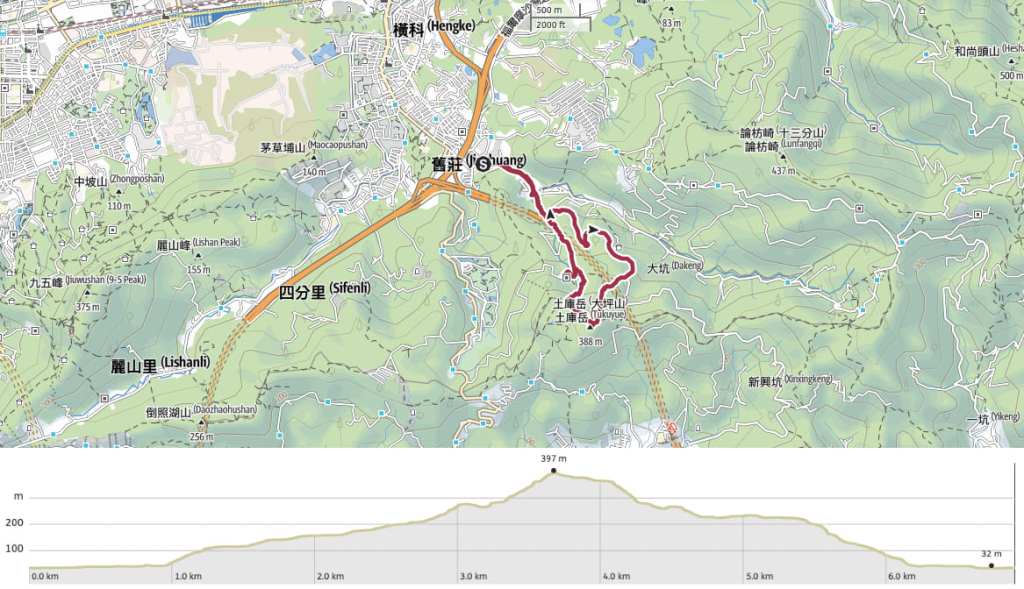
DISTANCE: A little under 7km.
TIME: About 2 -3 hours.
TOTAL ASCENT: Around 360 metres to a high point of 389m on the summit of Tukuyue.
DIFFICULTY (REGULAR TAIWAN HIKERS): 2/10 – For some steps and quite a few interlinking trails.
DIFFICULTY (NEW HIKERS): 3-4/10 – Navigation might pose a minor challenge in some areas if you’re not following a GPX route, and there are steps. Otherwise, it’s a pretty easy walk.
SIGNAGE: Mostly clear, but lacking in one or two spots.
FOOD AND WATER: I drank about 1L on a boiling summer day. Less would be required in cooler weather, and you can top up at Jiutian Temple on your way down.
SHADE: Some sections are nice and tree-covered, but not all of it. The road stretches are especially exposed.
MOBILE NETWORK: Weak in one or two places, but ok.
ENJOYMENT: I think I would have enjoyed this more had I chosen a cooler day to hike. The trail itself is very pleasant, and the summit has some nice views, but I was cooked.
SOLO HIKE-ABILITY: There’s no problem with hiking this solo. It’s safe and easy. The only part that made me feel slightly on edge was walking on the quiet backroads (but in Taiwan, I think that’s a fear borne of instinct rather than any real need to be worried).
TAIWAN 100 MINOR PEAKS: Number 14, Tukuyue (土庫岳).
ROUTE TYPE: Lollipop loop.
PERMIT: None needed.
Jump to the bottom of this post for a trail map and GPX file.
DIRECTIONS:

The walk starts and ends from Jizhuang 2nd Stop. From here, follow Jizhuang Street, Section 2 gradually upwards and away from the outskirts of the city.


The surroundings are that weird mix of scruffy residential, rickety industrial, and religious that you often get on the outskirts of Taiwan’s urban areas.

After about 10 minutes, the road and Dakeng Creek take a 90-degree turn to the left. This is where the trail veers away from the road and starts to climb up some steps.

There are actually a number of steps and lanes leading away from this corner, and because this white truck was blocking the finger post, I initially took a wrong turn and climbed up the steps to someone’s house. Once you see the signpost though, it’s clear that this is the right way. Head through the alley beside the stream.


The path leads around the back of someone’s house, and steps soon split off on the right just before you reach the resident’s private red-brick temple.

I followed a paved trail up through mostly scrubby secondary forest, but also a few patches of farmland.

The steps climb for about 300 metres to join Lane 122, Jiuzhuang Road, Section 2. This is the start of the walk’s loop section. Since the head was punishing, I decided to turn left and do a clockwise loop, which would allow me to do the majority of the climb following the roads. The benefit of this was that it enabled me to pace myself and not get too out of breath, but the downside was that the shade was patchy and even with an umbrella, I started to feel like I was being fried by the heat bouncing back from the tarmac.

After another 200 metres, the lane rejoins the main stretch of Jiuzhuang Road, Section 2. Turn right and continue to head uphill.


The road section was uneventful and quiet. Even on a Sunday when you might expect to see more people out and about, it was not busy. It took me 20 minutes to walk from the junction with Lane 122 to the trailhead leading to the summit of Tukuyue. Take the flight of steps heading into the trees.


I was simultaneously thankful to be out of the sun, and also slightly worried about how tired the exertion was making me. The heat this year has been really quite alarming and I think I’m going to have to modify my walking habits as a result.
From the road to the summit of Tukuyue, the 700-800 metres of trail goes steadily and consistently up, and I found myself needing to stop frequently to avoid overheating. (There are a couple of dips or flatter sections, but otherwise it’s all climbing.)

At the junction, turn left and continue to climb.


This final push was slightly cooler thanks to the presence of a storm-precursing breeze and a gentle trailside stream.

A blink-and-you’ll-miss-it dirt path leads away to the left from the main steps (towards the east peak), and soon after that, you’ll get to the final junction before the summit. Turn left here and climb the last few metres up to the top.

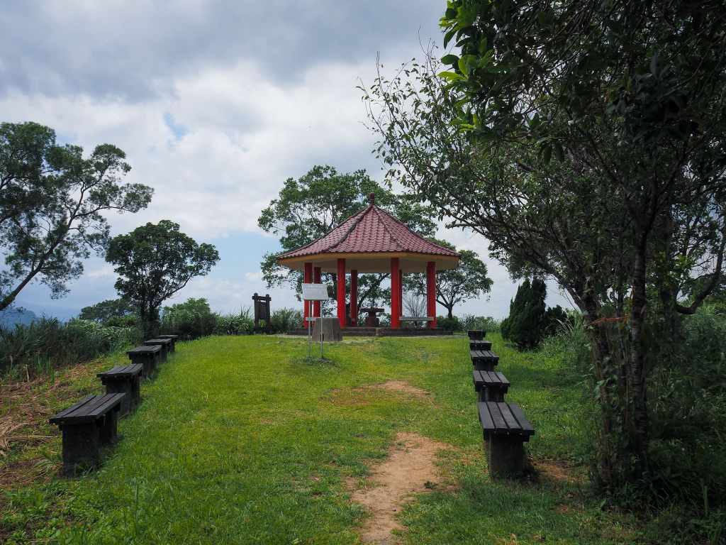
The summit is marked by an open clearing with benches, a fortress-esque triangulation stone, and a red-roofed pavilion.

The view from up here is partially obscured, but not too bad. However, when I saw the ominous grey colour of the approaching clouds, I decided to pick up the pace and head straight down.

Return to the junction and take the left path (not the one you came from).


After a couple of minutes, Gengliao Historic Trail breaks away from the main path by taking a right turn. Turn right onto the side path, and then almost immediately take the more-established looking left fork climbing up some ugly steps made of extruded concrete cylinders. (The other path on the right doesn’t appear on my map.)

This next couple of hundred metres is the most naturally-surfaced part of the whole wall.

Then, when you reach a pavilion, the path takes a sharp right turn and you’re on concrete steps again.


The trail emerges at the rear of an old sanheyuan (three-sided house) belonging to the Gao family. Look closely, and you’ll see repairs made by multiple generations.

Follow the trail around the front of the farmhouse, and then up a flight of steps.

After a brief climb, the steps start to head down again.

And soon I found myself walking alongside the old and rusting remains of the farm rail cart. It has been left in situ to allow city people to see how farm people do stuff (and to trip over the unwary).

Follow the steps down through an archway and turn left to keep heading downwards.

Soon the steps turn onto a sloping track and just where they join the road, you’ll need to take a sharp right to double back on yourself and keep following the path downhill.

If you have time, it might be worth making a detour to pop into the nearby Jiutian Temple. It has a water dispenser, toilets, and gods who are currently being aided by their human interpreters to compile a PDF of their spirit-writing teachings.


The path makes its way down through first forest, then farmland.


And soon I found myself rejoining Lane 122. Turn right at the bottom of the steps, and very soon you’ll back at the steps that’ll lead you to where the walk began.
HOW TO GET TO TUKUYUE
Google Maps address: The walk starts from Jizhuang 2nd Stop. You can easily find room to park a scooter around here, but parking a car would be a little harder.
GPS location: The entrance to the first flight of steps can be found at N25 02.096 E121 37.810.
Public transport: Take the Banan (blue) MRT line to Nangang Station, leave via exit 2A, cross over Zhongxiao East Road and catch the 212 Express Zhongxiao E. Road bus service from Nangang Station bus stop. Ride it for about 20 minutes and alight at Jiuzhuang 2nd Stop.
Further reading: There doesn’t seem to be any other English information written on the subject of this trail, but you can find many variations of the route described in Chinese.
TUKUYUE TRAIL MAP
GPX file available here on Outdoor Active. (Account needed, but the free one works just fine.)
