
RSB07 – RSB09
Even before I set about wanting to walk the entire Raknus Selu Trail, this spit of raised land separating Qionglin and Xinpu Townships had long been on my list of places to check out. But with this new goal in mind, and an itchy to escape Taipei for the day, it was finally the right time to get out there and give it a go
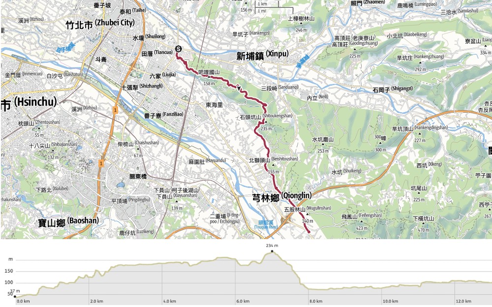
DISTANCE: About 14km.
TIME: 5-7 hours. I spent almost six hours walking with some long pauses.
TOTAL ASCENT: Close to 400 metres.
DIFFICULTY (REGULAR TAIWAN HIKERS): 3/10 – This would be on the upper end of easy for a seasoned Taiwan hiker for the length and all of the ups and downs.
DIFFICULTY (NEW HIKERS): 4-5/10 – This would be on the easy end of moderate for a new Taiwan hiker. It’s quite long with lots of ups and downs. Trail surfaces are a mix, with some overgrown sections, some loose rocks and some paved.
SIGNAGE: There’s signage, but it’s Chinese only, and much of what was there when I walked it had been put up by a hiking group that was obviously doing a slightly different trail to me, so although I was following their signs, the names of the places I was heading towards didn’t always match up with what was written on the signs. In short, make sure you have a map and know where you’re meant to be going.
FOOD AND WATER: I drank 1L on a hot day in May before getting to the town to refill. 1L wasn’t quite enough. Snack wise, I took dried tofu and salt candy, but only ate the latter. Once I got into town, I cooled off with some ice cream before continuing on my way.
SHADE: On the trails, the shade is patchy, on the road, you’re really exposed.
MOBILE NETWORK: Weak in some places, but not for long.
ENJOYMENT: There are some lovely views and the walking is pleasant, never too taxing. For me, walking during bamboo harvesting season was a bonus.
SOLO HIKE-ABILITY: There’s no reason why you shouldn’t do this walk solo. There isn’t any English signage, but equally, you’ll be following a ridge between two built-up areas, so there isn’t really anywhere to get lost.
ROUTE TYPE: Point to point.
PERMIT: None needed.
RAKNUS SELU TRAIL SECTIONS COVERED:
This route exclusively covers sections of the Raknus Selu B Route.
- RSB07: Mount Litou Hiking Trail (犁頭山登山步道)
- RSB08: Sanduanqi Historic Trail (三段崎古道)
- RSB09: Hsinchu District Road 22 (竹22)
Jump to the bottom of this post for a trail map and GPX file.
DIRECTIONS:


09:30 – I decided to start this day’s walk from the junction of County Highways 117 and 118. In part this was just an arbitrary decision because a walk has got to start somewhere, but it also happens to be a pretty convenient spot to access from Zhubei Train Station. From the junction, walk southwest on County Highway 117 for about 300 metres, then take a left turn onto Wenhua Road and walk under the Lianhua Temple’s archway.

There was a group of old folk sitting in the shade of a pavilion to the left of Lianhua Temple (蓮華寺) when I arrived. In the UK, I got accustomed to groups of construction workers catcalling me inanities, but in Taiwan, this type of gathering of pensioners is the more usual culprit (although in fairness, the Taiwanese version is usually not rude).


The temple was originally constructed in 1878 to worship Guanyin, but was severely damaged during the widespread fighting that ensued following Taiwan’s annexation by Japanese forces. It was rebuilt in 1904, and has been repaired so many times over the intervening decades that the outside now looks almost new. Head inside though, and you’ll find old incense-stained beams and brickwork. When I ventured in to take a look, a volunteer Temple guardian told me I should have visited a day earlier to see it full of visitors, and when she found out that I don’t have any children (because aunties always ask), she advised me to pray to Zhusheng Niangniang on the lefthand side altar. Being in not-much-caring mood, I outed myself by telling her that since my other half is also female, it would take more than a prayer to make that happen. The poor woman was momentarily flummoxed before rebounding with “Ah, I see, so you two just look after each other?” Yes, temple aunty. We do.

09:45 – The walk starts from the steps just beside the temple. Actually, steps run up both sides and join up at the rear in a garden of sorts.


09:50 – The bright roof strikes a dramatic contrast against the beige-grey towers of modern Hsinchu. Follow the steps up to the top right corner of the temple garden. Here you’ll find a dirt trail cutting through the greenery.


09:52 – A trail leads through scruffy grass to a track where a whole load of old car parts had been dumped. Turn right onto the track, then after about 20 metres, take a left turn back onto an easily missable path.


09:57 – This is the most overgrown and unpleasant section of the whole walk. I had many spider webs to the face. Thankfully though, it’s over in five minutes. When the path emerges onto a track, turn left to follow the track uphill.


10:02 – The track soon gives way to a narrow trail, which climbs steeply up for a short way before arriving at this hilltop clearing. Turn right past the metal structure.

There’s a lot of construction work going on near here. Some of the disturbances to the earth look recent, but there are also places which look like they haven’t been worked on in years. The hill also offers the first look at the view that will accompany you for most of your journey.


10:09 – For a short way, the path runs along the edge of some scrubby land. Along this stretch, a giant hornet flew straight towards me at eye-level. Hornet and I were both momentarily shocked by each other’s sudden and unexpected appearance, but I backtrack and the hornet went left, so everyone emerged from the encounter unscathed. Keep going along the path until a trail darts off the track to the right.

This is where you’ll find out what the trail is all about. From this point on, it’s all short ups and downs along a dusty ridge line with occasional views over Hsinchu’s flat rice paddies.

10:20 – From a vantage point on an exposed part of the trail, I watched one southbound train pull into the station, and a northbound one depart. It’s been a long time since I watched any anime, but something about this smooth, futuristic-looking train speeding quietly through fields of wind-rippled rice into the smoothly arched shelter of the station feels distinctly Japanese. It might also have something to do with the fact that the trains playing Taiwan’s HSR are Japanese… or indeed that I have never actually been to Japan and only have half-memories of films watched years ago to fuel my imagination.

10:37 – A little further along, there is another opening in the trees, and this time I found myself almost right on top of the train tracks.

10:45 – The views come frequently over this next stretch of the trail. There’s a seating area with a large picnic table here at the top of Litou Shan (犁頭山). The name means “Ploughshare Hill,” so I guess maybe the farmers walking behind their water buffalo in the fields below thought it resembled their tools.

Wenshan Trail (文山步道) joins from the left beside the rest area, but the route I was following continued straight along the ridge. Looking out over the plains, I spotted several old friends. The highest peak to the right is Mount Jiali, then right bang in the centre of the photo is the unmistakably five-pronged Five Finger Mountain, and much higher and to its immediate right is the beaky protuberance of Mount Egongi. The familiarity of knowing these by sight feels good in a way that’s hard to describe.

A trail joins from the right. Ignore it and continue to follow the ridge straight ahead. (Turning downhill here would lead you onto the same road that the HSR station is on—after a little wandering through farming lanes.)

11:02 – The next noteworthy feature is Baliguo West Peak (吧哩國山西峰).


The trail between the west and main peaks dips and climbs along a wooded ridge.

11:07 – And very soon, I found myself at the main peak. It was slightly more sheltered than the west peak, so the views weren’t as good. But I did enjoy several minutes spent stopped to watch some burrowing wasps fight over territory and work on some tunnel maintenance. There are two ways to leave the summit. Make sure to take the one heading straightish and along the ridge (as opposed to the one heading downhill to the left).


I saw a few tung blossom trees off to the side of the trail, but few along the path. The scant blossoms I did see had all been wilted by the relentless heat.


Enjoy the last few views, because before long, the path becomes shielded by trees on all sides.

11:29 – At the next junction, turn right. (I don’t think the lefthand track was on my map at all.)

Despite the lack of distant views, the trail is still quite pretty. The bright orange earth contrasts pleasingly with the greenery of mixed secondary-growth woodland.

I was also more than a little happy to be under the shade. With temperatures over 30°C before noon, any time spent out of the sun was welcome.

11:37 – The trail cuts across the access road for some type of construction project. Judging by the rawness of the earth (and the laminated notices affixed to the trees), this work is pretty recent.


When you hit this track, take a left turn. The track bends to the right after a short distance.


11:53 – Another short while later, the path splits once more. Here, turn left again following signs for Sanduanqi Historic Trail (三段崎古道). The trail cuts across some more fresh construction work.

For much of the rest of the trail, I found myself walking through patches of bamboo forest.


There are a few more side trails branching off along this stretch. In each case, you just need to follow the more defined route, so head straight in the photo on the left, then hook a right at the spot in the righthand image.


12:11 – At this junction, the trail heads straight up. To the left of the path, there’s a concrete marker indicating that water from here flows down to join the Touqian River, and to the right, there are some brick pillars that once used to be Kangrifeng Pavilion (抗日奉茶亭).

The path continues onwards. I think it was somewhere around here that I met a couple coming in the opposite direction. Since I went midweek, it was a very quiet walk—I only met four humans and a poodle the entire time I was on the trail.

As I was walking along this stretch, I noticed a young bamboo shoot poking out from the bed of fallen papery leaves. Peering into the undergrowth, I spotted a couple more, along with a pile of tell-tale husks indicating that someone else had picked bamboo from here in the not-so-distant past. I had been wanting to try foraging for bamboo ever since I noticed people doing it on the trail near my house, and since I had both my penknife and a spare bag to hand, I decided it was the right time. I amassed a modest haul before setting off on my way again,
Shortly past this point, there was a kind of junction. I say kind of because the left track was blocked with the remains of a dumped car. Keep heading straightish until you find yourself on a lane.


12:52 – Wende Road, Section 3, Lane 339 cuts straight over the hump of land between Xinpu and Qionglin. Take a right turn onto it, then walk about 100 metres until you reach the turn-off on the left.

If you didn’t already know that this section of path was a historic trail, you would soon be forced to come to that conclusion. The first hint is this ginormous camphor tree with its limbs sprawling out in all directions. The photo doesn’t come close to showing what a presence it has. You can feel that it has presided over this patch of land for many, many years.

12:56 – Your second clue is this adorable land god shrine. Shipeng Tudi Gong Shrine (棚土地公廟) is cute both by dint of being small, and also because it has been built out of the local rounded stones (it’s more common to see them built using cut rock or sharper-edged slabs), which gives it a squishy feeling.


12:59 – A third clue comes in the form of this ramshackle mud-brick farmhouse built far away from any roads.

13:00 – The farm appears unoccupied, but someone is obviously still maintaining the farmland around it, and when I walked down through bamboo to the stream, I found that whoever farms the land has installed a slightly sturdier bridge to help them get to their vegetables.

And finally, just in case you still had any doubt as to the historic nature of this route, the stretch between the old farm and the road is mostly done along this exquisitely built old stone trail.


At the next junction, take a right and head downhill. When you find yourself walking on a flight of uniform stone steps, you’ll know you’re nearly at the end of the trail portion.

13:22 – The trail emerges onto an agricultural track. Steps straight ahead lead up to a covering platform, but to continue along your way, you’ll need to take a left turn and follow the road downhill. I rarely get discombobulated while out walking. I seem to have some kind of internal compass that normally lets me know where I’m meant to be going, but this turn here threw me for a loop. I’d somehow failed to register just how much the trail had curved to the right, so turning left felt like it would take me in entirely the wrong direction.

There were hundreds and thousands of butterflies all along the trail all day but few were as obliging as this great Mormon swallowtail that I saw on my way down to the main road. This blue one is a male, but the females of the species are especially interesting because they are both polymorphic (meaning they have multiple colours and patterns), and mimetic (meaning that some of those colours and patterns mimic other species). As is implied by the “greater” part of the name, this species has a smaller cousin, known as the common Mormon swallowtail, which shares the same polymorphic and mimetic qualities. Eventually, the species was named after the Mormon sect (famous for its acceptance of polygamy), because thanks to the varied colourations of females, it would appear that one male can have several different types of mate.

The track winds its way down towards the flat land, passing a farm or two along the way.


13:38 – Where the track finally reaches civilisation, cross over the culverted stream, then turn left onto Hsinchu District Road 22. The road is entirely exposed, but at least the prettily rural scenery was able to distract me somewhat from the heat.


At each junction, stick with Hsinchu District Road 22, so right/straight in the first photo and left/straight in the second.

The road follows the stream all the way. (It’s kind of hidden behind the grass on the left.)


Left at the next junction. A number of houses have steps outside them leading down to a waterside seat for washing clothes and vegetables (I only saw one house where this appeared to still be in use though).

14:05 – The road I had been following merges onto County Highway 123. Keep heading straight here.

14:09 – One of the more interesting sights along the way was this. Lushi Waterwheel (綠獅水車) is part of an old rice mill that was in existence from some time during the Japanese occupation of Taiwan. At that time, huge tracts of land in Hsinchu County were pressed into service as rice paddies—there was a large demand for Taiwanese rice in Japan, and so in order to process the grain on a larger scale, Jin Yufeng Rice Refinery (金玉豐精米所) was established. In the 1970s, the mill switched to an electrical power source, and it continued to operate until land rezoning forced it out of business in 2009. Its fate was briefly in the hands of private developers, but it’s now owned by Hsinchu Government, which aims to preserve it as a cultural relic.

14:17 – As I neared the edge of Qionglin Town proper, I was mighty relieved to see FamilyMart come into view. I was sweltering in the heat, and decided to duck inside for some cold coffee and air conditioning.


Suitably refreshed, I decided to get back on with the way. I debated whether or not I wanted to take a shortcut down the market street, but instead, I carried on an extra thirty metres or so until I came to this narrow lane on the right. (You could also just follow the main road.)

14:44 – The reason I had wanted to take the narrow lane is because I could see there was a temple down there, and I was hoping to fill up my water bottle. Guangfu Temple (廣福宮) did not disappoint. It had a nice, clean water dispenser, which I gratefully used.


It also had quite a lot of evidence of animal cruelty cultural practises involving animals. On the right, the wall is hung with photos depicting holy pigs (神豬) either shortly before or shortly after slaughter—the poor creatures are fattened up into caricaturesquely grotesque lumps of flesh, so obese that their final weeks are spent confined to their stalls. When the time comes, they’re sacrificed with a ceremonial dagger before being skinned. The flattened-out skins are stretched taut across display frames, dehaired and painted, and the resulting travesty is paraded around as an offering to the gods. While I’m aware that I’m a perpetual foreigner in this land and maybe not the best person to be judging cultural practises, this really does feel like something that shouldn’t be perpetuated in modern-day Taiwan. Thankfully, it seems that some temples have found alternatives—while visiting nearby Xinpu a year earlier, I saw one of the temples there had forged slightly more ethical Holy Pigs out of dozens of bags of crisps strapped together in the shape of an overweight pig.
In addition to the pig photos, there was also a decapitated goat. I’m not sure what the goat had done to deserve being exhibited there, although the last time I came across a goat’s head in a temple in Taoyuan, it was there just because it had long horns.


I made my way back onto County Highway 123. From here, it’s just a whole lot of heading straight and not much else.


15:19 – Just before you reach County Highway 120, you’ll pass the turn-off for the next section of the Raknus Selu B Route (Fei-sha Trail or 飛沙縱走), but for now, head straight until you hit the 120, then turn right and walk the short distance to the bus stop.
If you’re a real completist about these things, you might want to follow County Highway as far as the junction with Wuhe Street (which is where you’d connect up with RSA18), but you wouldn’t be missing a huge amount if you skipped this part. This would take another hour or so—perhaps two if you push on to Jiuzantou Station for easier transportation back to the cities.

After returning home, I was very excited to give my foraged bamboo a try. That was matched with apprehension since the plant needs to be properly cooked in order to be rendered edible. Thankfully, I was able to enjoy my hard-earned reward without suffering any ill effects.
GETTING THERE
Google Maps address: I started this walk from the Lianhua Temple bus stop. There is a limited number of parking spaces in front of Lianhua Temple, but since this is a point-to-point walk, you’d be better off taking public transport.
GPS location:
- Lianhua Temple trailhead – N24 49.630 E121 02.225
- Sanduanqi trailhead – N24 47.955 E121 04.080
Public transport:
- Getting to Lianhua Temple – You’ll need to catch a train to Zhubei Station (both local Fuxing/Shuttle trains and Tze-Chiang Limited Express Trains stop here). From there, you could catch a bus, but it would probably be easier to just hop on a YouBike. Alternatively, you can do something similar, but start by taking the HSR to Hsinchu Station. (I did the HSR and YouBike combo because I wanted to check out a vegetarian breakfast shop in Hsinchu.)
- Getting back – To get back from the end, catch the 1820 or 1820A back to Taipei from this bus stop on County Highway 120.
Further reading: For more on the practise of offering Holy Pigs, check out this post from Josh Ellis.
MOUNT LITOU & SANDUANQI TRAIL MAP
GPX file available here on Outdoor Active. (Account needed, but the free one works just fine.)
