I recently spent a night holed up in a B&B just off Neiwan Old Street in the course of walking the Raknus Selu Trail. While laying in bed, I idly scanned the nearby hills for potential future adventures and saw this route. In the past, this trail used to be the main route connecting people from the Matai tribal village with the outside world. That changed when Hsinchu District Road 59 was built, giving the village residents quicker and easier access to the rest of the world. Rather than being forgotten to time entirely, the trail has been preserved as a historic path and is now a lovely place to spend a summer afternoon.
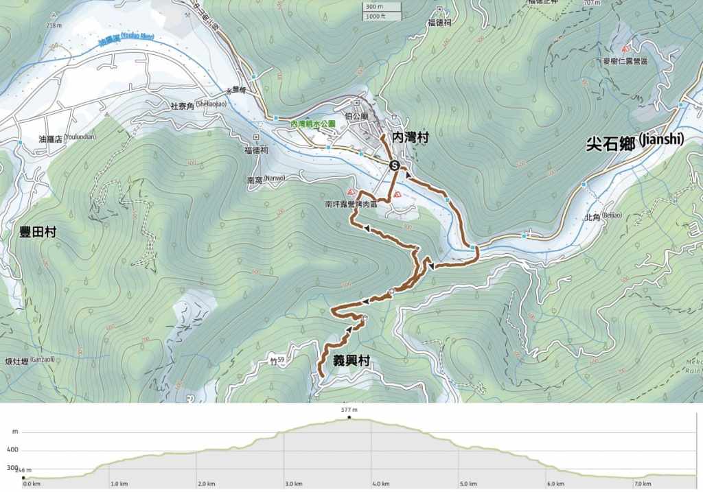
Distance: About 7.7km.
Time: It took me almost exactly three hours to complete this walk. If I had stopped for lunch or snacks at the top, it would have been a little longer.
Difficulty (regular Taiwan hiker): 3/10 – There are some steep climbs, some muddy sections, and some parts where the trail is a bit broken, but overall, this is quite an easy walk.
Difficulty (new Taiwan hiker): 4-5/10 – For new hikers in Taiwan, this would probably be on the easy end of moderate. The signage isn’t great (I think it’s all or mostly all in Chinese), and if you’re unfamiliar with the landscape, it might feel a bit wild. However, the trails are clearly defined and well-used and there are no side trails that could get you lost.
Total ascent: Around 380m.
Food and drink: I took (and drank) 0.5L of water and about the same amount of iced coffee. That was ample on a hot day. You can top up in Neiwan. The station doesn’t have a water dispenser, but you’ll find a tea dispenser at the nearby temple, and you can always stop by the 7-Eleven to stock up before you start walking. At the top end of the trail, you’ll find a small farmstead selling snacks and bottled drinks, and on busier days, the village has a couple of small restaurants.
Shade: This walk is mostly very well-shaded. I didn’t need to take my umbrella out until the last little road section walking back into Neiwan (and that was only for the rain).
Mobile network: OK throughout.
Enjoyment: There’s a lot to enjoy about this walk. It (potentially) involves a ride on the cute Neiwan Line, it starts and finishes at Neiwan Old Street, and the walk itself follows pretty historic trails along a stream. And if that wasn’t enough, if you visit on a weekend, you can enjoy lunch or a drink stop at the top of the trail.
Route type: Loop with an offshoot.
Permit: None needed.
Jump to the bottom of this post for a trail map and GPX file.
When I arrived at Neiwan Old Street, it was still waking up for the day. Tourist towns like this don’t really get going until a little later on. Before beginning my walk, I went searching for somewhere to fill up my water bottle, and after drawing a blank at the train station, I headed up to the northern end of Guangji Road to pop into Guangji Temple. There, I met a little old lady who told me three times that she’d grown up in Neiwan, then that she’d married a local man and that she had Alzheimer’s. She also insisted that I fill up my bottle with temple tea.

With my liquid needs seen to, I turned back and walked south along the old street towards Neiwan Bridge (the road bridge where the bus drops you off), and the town’s only 7-Eleven to pick up some extra provisions.

The 7-Eleven sits on a junction beside Youluo River (油羅溪), and from its windows, you can see Neiwan Suspension Bridge. This is where the walk starts.


As I crossed over the bridge, I looked upstream towards where the mountains stack up higher and higher, and downstream, I spotted some families with fishing nets and buckets blatantly ignoring the signs telling people not to go in the water.


A track leads you away from the far end of the bridge, and at the end of that you’ll need to cross over and bear rightish up a lane. I encountered a sad-looking pair of tied up guard dogs that barked ferociously, but then cowered away from me when I drew close.

There are many businesses along this stretch of road, but the vast majority of them look like they’re probably no longer in operation.


Just past a small B&B with a butterfly-filled bushy border, you’ll need to take a left and start climbing up lane lined with more small businesses. There is a sign reading “南坪古道” close to the bottom of the lane, but if you don’t read Chinese, there are no obvious signs that this leads anywhere. The trail starts from the topmost edge of this lane.

There is a steep section of steps to kick things off, but don’t worry, it’s not like this the whole way.


The trail obviously has not received regular upkeep and repairs. There are several areas where the path or railings look a little worse for wear.

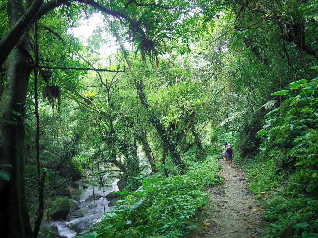
At the top of the steps, I started along the first really pleasant section. The slope rises to the right of the trail and drops to the left. Both sides are lush with all sorts of greenery.

Although the climb is not as steep, it continues to climb from the top of the steps up to this narrow cut through a rocky passage. As soon as you make it through to the far side, the roar of one of Youlou River’s youthful tributaries cuts through the forest.

Distance markers along the trail let you know how far you’ve come. Right as I was passing this one, a bright green flash of an emerald dove zipped across the path in front of me.

The noise of the water grows steadily louder as you make your way down to this shelter. This is where Neiping and Matai Historic Trails merge. (Later, I would return to this spot and take the lower path heading back to the road.)


As you keep following the trail upwards, for a short and pleasant stretch, you’ll find yourself walking beside the water. The trees here wear their ferns like dripping jewels.

Soon, I found myself at the trail’s suspension bridge.


For kids (and plenty of adults), this bouncy bridge will be the highlight of the walk.

The next couple of hundred metres beyond the bridge was my favourite part. The path follows close to the stream and in many places, you can see the clear water cascading over the rocks and into tempting pools.


Summer in Taiwan is an especially good time to see all of the impressive buglife.

As the trail starts to veer away from the stream, it begins climbing again. Thankfully, it’s all nice and shady though, so I didn’t get too hot.


The final portion of the path takes you through a landscape dominated by stands of tall bamboo.

Then all of a sudden, you’ll find yourself walking through a cultivated garden area.


I was charmed by the free-range chickens living on this farm/small snack stall.

If you follow the track left past the snack place and keep heading up to the village, you’ll eventually reach the village’s small mountainside church. There are also a couple of restaurants here, but in a Monday, everything seemed closed.

From the church, I turned and retraced my steps back the way I’d come, taking my time to enjoy the pretty sections.

A splendid fern-decked tree.

In a couple of spots, it’s possible to get down to the water and dip your toes in.

Once I made it back to the first shelter, I took the lower trail on the right. (This is Matai Historic Trail.)

There were lots of these giant jewel orchids beside the trail.

This section is not quite as pretty as the upper portion, but it’s still quite pleasant.


A muntjac decorating a bench and some leaves with curiously bright green centres.


The trail climbs down to cross the tributary stream once more, and you can almost enjoy a view across the valley.


There were thousands of damselflies (and dragonflies) flitting along the path. In fact, at this one spot, there were so many that it seemed they were queuing, one to a leaf.

The trailhead for Matai Historic Trail is marked by this decorative board. From here, it’s not far back to Neiwan.

You’ll need to cross over the bridge.


Then on the far side, turn left and follow the road all the way back into town.


By the time I arrived back, a few more stalls had opened, but it was still quiet. I had a brief wander to kill time before the train came to whisk me back to the city.
How to get to Neiwan
Google Maps address: Generally speaking, the walk starts and ends at Neiwan. There are some parking options around here, but if you come on a weekend or holiday, it will be hellishly busy. If you want to use your own transport, you might find it easier to park either at the exit of Matai HistoricTrail, or else partway along the road back to Neiwan.
GPS location:
- Nanping Historic Trail trailhead – N24 42.035 E121 10.835
- Matai Historic Trail trailhead – N24 41.830 E121 11.370
Public transport: There are two ways to get here. One is quicker and more expensive, the other is slower but cheaper. (Getting back is the same but in reverse.)
- The quicker way involves taking the HSR to Hsinchu, then transferring onto the Neiwan Branch Line. This is almost easy since Liujia TRA Station is right next to Hsinchu HSR Station. However, you’d still need to transfer once more at Zhuzhong, where you’d have to catch a Neiwan Branch Line train and ride it all the way to Neiwan. Since the one-way HSR ticket alone costs over NT$300, you have to weigh up whether you prefer to have a lie-in or keep your money.
- The slower way involves catching the 1820 Kuo-kuang bus from Taipei Bus Station to Zhudong. The 1820 via Longtan and the 1820A via Guanxi Downtown Area both take you there, and I think you’ll need to go to the station’s fourth floor to catch the bus (you can pay by Easy Card). You’ll need to alight at Dongning Road or another stop in Zhudong and walk to the train station. From there, you can catch a train to Neiwan. This method is slower and cheaper, and it also allows you to see a little of Zhudong. As I was walking through the town, I found the largest mangoes I have ever seen. They were genuinely as big as my face. Apparently they’re called “big apple mangoes” because they’re big and taste something like a cross between a mango and an apple.
Further reading: There isn’t much English info out there on this subject, but you can find plenty in Chinese. Tony Huang’s video is a good place to start:
Nanping and Matai Historical Trails
GPX file available here on Outdoor Active. (Account needed, but the free one works just fine.)
