Sometimes, I just get a strong hankering to break free of Taipei. Luckily, the transport infrastructure in Taiwan means that this doesn’t need to be a long and arduous multi-day trip. On a sunny August day, I was able to wake up at seven be in Yilan by 10-sh, explore two trails and a hot spring, and still be back in time to have dinner in Taipei with my other half.
This coastal trail in southern Yilan’s Nan’ao Township was my first stop of the day. The walk offers pretty views of the vivid blue ocean, and the town of Nan’ao itself is also worthy of a brief wander.
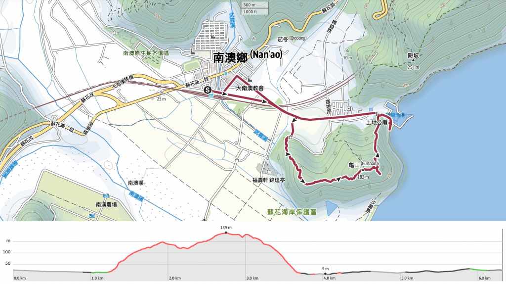
Distance: 6.3km
Time: It took me a little under 2½ hours to make a lazy loop from the station. Had I parked at one of the trailheads and/or walked this in cooler weather, I think 2 hours would be more realistic.
Difficulty (regular Taiwan hiker): 2/10 – Some steps, which felt like quite a lot in the heat, but would have been fine in cool weather.
Difficulty (new Taiwan hiker): 4/10 – Even for a new hiker, this would still be considered an easy walk. The trail has few junctions, and they’re all signposted in both Chinese and English, so it’s not difficult to follow.
Total ascent: Around 260m.
Water: I was fine with 0.5L, but I refilled my bottle from a temple on the way back. The train station also has a water dispenser, so make sure to fill up before you set off.
Shade: Much of the actual trail is shaded, but on the road walk to and from the trail, I felt like I was literally drying in my skin. (For context, I walked this at the need of a scarily hot August.)
Mobile network: Reception was clear throughout
Enjoyment: This is a nice little trail. Save for the coastal views, there’s nothing particularly outstanding about it, but combined with a wander around the pleasant town of Nan’ao and a visit to the nearby Dongyue Cold Speings, this made for a full and enjoyable day trip from Taipei.
Route type: Loop
Permit: None needed
Jump to the bottom of this post for a trail map and GPX file.


My train landed in Nan’ao just a little after 10:30, and upon leaving through the station hallway, I was greeted by the impressive sight of cloud-capped mountains rising beyond the small town. Instantly it’s clear you’re not in Taipei anymore.


There is a little purple shuttle bus that’ll take you from the station to nearer the start of the trail (if you time it right), but I decided to walk instead. Turn right out of the station, cross over Nanqiang Bridge, and follow the road running parallel to the tracks.


If you keep following the same road, you’ll pass Zhen’an Temple on your left, and then pass a row of abandoned houses before reaching a junction.

Merge right/straight onto Nan’ao Road and follow it as it passes under the railway tracks.

To me, this just feels like quintessential east Taiwan scenery: huge blue sky with towering white clouds, green forest-clad hills, and even greener fields.

Take a right turn onto Jianguo Road (建國路) beside a sign depicting farmers at work and two people who appear to be dressed up as a pantomime water buffalo.

The road curves around to a junction, and right at that spot, you’ll see steps leading up into the trees beside a row of decorated cottages.


The trail climbs steadily up steps made of wooden planks held in place with metal rods. As I walked, the summer hum of cicadas filled the air. I didn’t see any, but I spotted many of their abandoned and earth-dusted nymph husks still hooked on the trees.

As it climbs, the trail passes under an electricity pylon.


For a brief stretch beyond the pylon, I found myself heading downhill again. As I did so, I began to hear the sound of the waves crashing on the shoreline to the right of the trail.

Then, there’s a second push up to the summit. The trail here passes through small patches of skinny bamboo and sprawling, scruffy screw pine. It feels decidedly coastal in its mix and makeup, but I’m not sure I could tell you why.

It took me about 40 minutes to climb to the summit of Turtle Mountain (龜山). I find it a little odd that this hill has exactly the same name as the island you can see a little further north off the coast of Yilan. I guess back in the naming things days, there weren’t so many names to go around and they had to be recycled every 40km or so. I met a small hiking group going in the opposite direction, but they breezed straight on through without stopping.

Just beyond the summit, the trail splits in two. I took the righthand path which leads down to the trail’s official entrance via a series of lookout spots.

In the summer heat, I was delighted to no longer be climbing.


A pair of spiky things passed on my descent. Thankfully, neither of them were interested in bothering me.

Five minutes after leaving the peak, I came to another junction. The trail continues down to the left, but first, it’s worth heading up the path on the right.

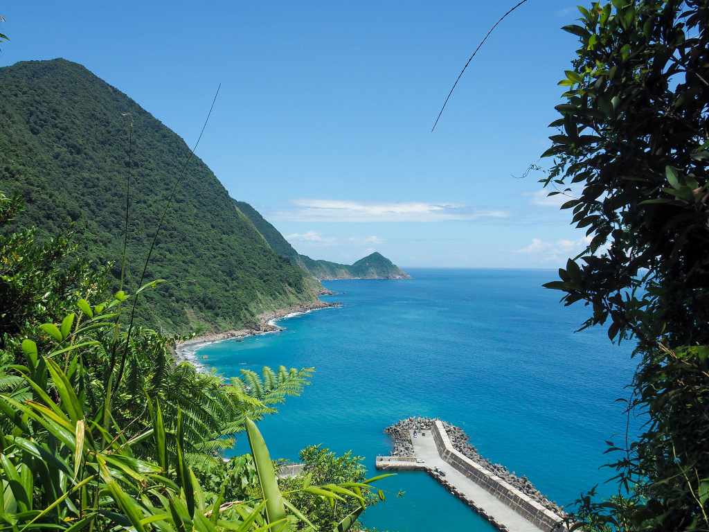
This 100m-long side trail takes you to the first of several lookout areas offering views over the ocean. Tree stump seats have been scattered around the clearing, and if you walk right up to the railings, you can see the coastline stretching away to the south.


Returning to the main path, I continued my downwards journey. The terrain here becomes steeper and a bit more interesting. There are lots of odd hollows from where the bedroom has been gradually eroded into holey channels. Then the second viewing area came at the 700m marker. (There are markers every 100 metres, and I was working my way down towards zero.)

This second spot gives you a north facing view looking out over the arm of Nan’ao Harbour as it points towards Wushi Cape (烏石鼻).

The descent felt considerably steeper than the climb, and in several places, it zigzag back and forth a bit to make the steps less steep.


There were many, many butterflies on the trail. Lots of them weren’t willing to cooperate with photos, but these two stayed still for long enough to be photographed. On the left is what I think is a Penthema formosanum, and I think the right one is maybe a beautiful leopard (a confusing name for a butterfly species, even if I can see why it’s called that).

The steps emerge at the official start of the trail, which is marked by a sign fashioned from logs as well as a couple of smalls restaurants selling freshly caught fish.


To head back to the start of the trail, you’ll need to turn left, but before that, it’s worth taking a brief detour to the right to visit the ocean. You can walk onto the pebble beach, and somewhere in the cliffs around here there’s an abandoned copper mine.

Feeling hungry, I decided to make my way back toward Nan’ao and go in search of food.


If you follow the road straight, you’ll pass through a small village before meeting up with your earlier footsteps again.


A mantis eyeing me up suspiciously from a dragonfruit plant and a pair of waders upended on bamboo poles to dry out.

Rather than heading directly back into down, I took a minor detour to visit Zhen’an Temple.
I’m glad I did. I was able to fill up my water bottle here, and also have a chat with the two temple cats. Just before you reach the temple, there’s also an engraved stone stele in a free-standing shelter commemorating the construction of the original Qing-era road connecting Hualien with Su’ao.

From the temple, I continued up Nan’ao Road until I met the unnamed lane leading to the elementary school. Originally, I’d intended to eat at 南澳好糧食堂. It’s a small establishment where the chefs use local seasonal local ingredients and the vegetarian set meals looked amazing. Unfortunately though, when I arrived, they’d sold out of the vegetarian option so I had to head onwards to my backup option of Pu Yan Lajiao Restaurant. This second shop has made a name for itself selling all things spice—ice cream included. It’s an interesting gimmick and my noodles were nice enough, though the “vegetarian” set came with chicken soup. For dessert, I had spicy mango ice cream. There’s a weird cognitive dissonance in eating something cold and fruity which simultaneously sets your throat aflame.
How to get to Zhaoyang National Trail
Google Maps address: I started and finished my walk from Nan’ao Train Station, but the actual trail portion of the walk starts close to Zhaoyang Fishing Harbour (or Chaoyang Fishing Harbour). There is parking for both cars and scooters here.
GPS location:
- Town-side trailhead – N24 27.545 E121 48.575
- Harbour-side trailhead – N24 27.675 E121 49.135
Public transport: You can either take a train directly from Taipei to Nan’ao, or do a combination of bus and train. The calculation of which option makes more sense depends on where you’re starting from and what time you set off. Time and money-wise, it worked out being better for me to take the 1570 bus from Taipei City Hall Bus Station to Luodong Transfer Station and then catch a train from there to Nan’ao. Returning is the same but in reverse.
Further reading: Nan’ao and the surrounding area have been mentioned in passing in a few other places, all of which would give some handy pointers for what else to do with your time in this neck of the woods. This Taiwan Everything article features several points of interest, including nearby Dongyue Cold Springs and Snake Hill—they even visited the same restaurant that I did. Nick Kemble also visits the top reaches of the Suhua Highway in this post.
Nearby trails:
Zhaoyang National Trail Map
GPX file available here on Outdoor Active. (Account needed, but the free one works just fine.)
