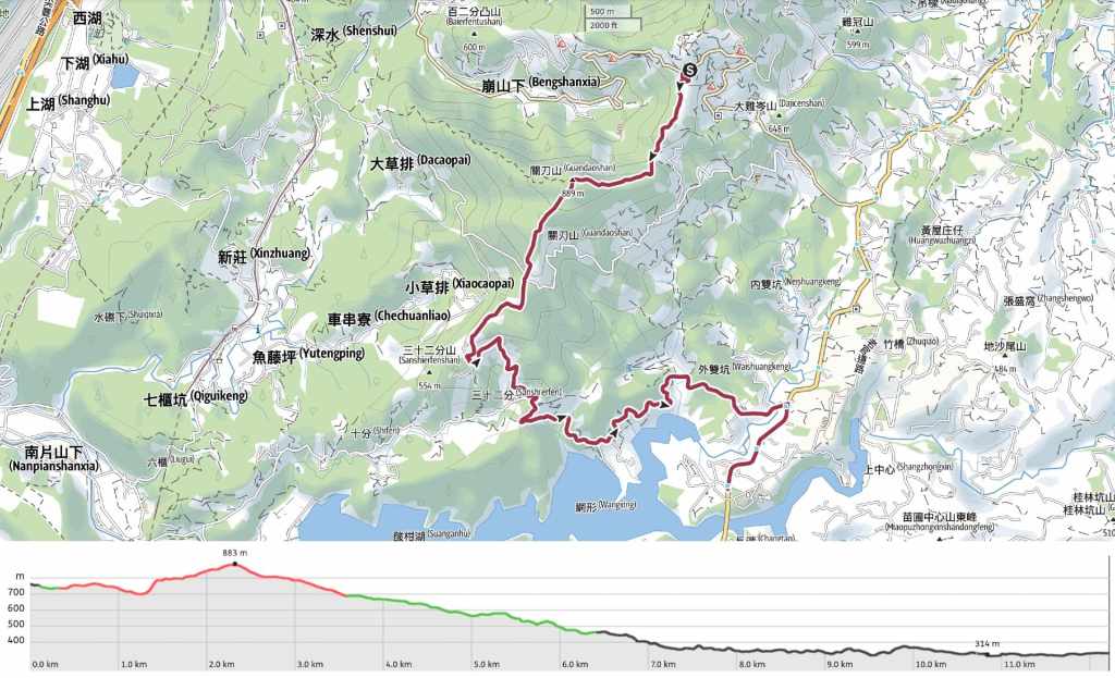
RAKNUS SELU TRAIL – SECTIONS RSA50 – RSA51.2
If you plan to walk the RST as a through-hike, you’ll have to choose between the route that cuts through the strawberry-field-filled valley around Nanhu and follows Laoguanlu, or this one which takes the high road via Ginger Garden and goes over the hills instead. Faced with that choice, I think I’d have to pick this version because the views and trail scenery are more interesting (but of course, I didn’t need to pick, so I did both).
Day 12 on this version of the route starts off at Ginger Garden, climbs up to Guandao Mountain (one of the Xiao Bai Yue) via a lovely historic trail before following a winding road above Liyutan Reservoir on its way back to join Provincial Highway 3.
RAKNUS SELU STAMPS: The stamp for RSA50 is located inside the shop/visitor centre at Ginger Garden right at the start of the walk. This place is open 8am-5pm daily.
DISTANCE: 12.2km for the walk covered here, but if you decide to walk over to Zhuolan, it’ll be a total of 17.2km (the extra is all done on roads).
TIME: It took me 4.5 hours to walk from Ginger Garden to Xinkai, but if you plan to reach Zhuolan, 5.5-6 hours is a safer estimate of the time you’ll need.
TOTAL ASCENT: About 300 metres for the route covered here (or 450m if you walk on to Zhuolan).
DIFFICULTY (REGULAR TAIWAN HIKERS): 2-3/10 – There are some slippery sections, and if you walk the whole 17km as I ended up doing, it’s quite a long way, but the walking is safe and easy.
DIFFICULTY (NEW HIKERS): 4-5/10 – The distance would be the hardest part for a new hiker, but if you’ve got the stamina, you should be ok.
FOOD, DRINKS & PIT STOPS: I took about a litre of water and drank most of it (but I did also walk on a little further to Zhuolan.) There are restaurants and stores selling a basic selection of snacks at the start of this trail, but literally, nothing else until you reach Provincial Highway 3.
TRAIL SURFACES: Dirt trail at first, then farm track, then road.
SHADE: The latter portion following the road is quite unshaded. I had to pull out my umbrella to stay non-crispy.
MOBILE NETWORK: Clear throughout.
SOLO HIKE-ABILITY: There’s not really anything about this which would make it dangerous for a solo hiker. Navigation is pretty straightforward, and the trail isn’t difficult. Just a dog or two to keep your eye on.
OTHER: Softer-soled shoes will make the road section feel more comfortable.
SECTIONS COVERED: In this post, I have covered the following sections, but if you end up walking on to Zhuolan, you’ll also cover RSA55.1-RSA55.3.
- RSA50: Chuguan Historic Trail, Shengguan Section (出關古道-聖關段)
- RSA51.1: Chuguan Historic Trail, Shengguan Section → Farm Road → Miaoli District Road 52-3 → Provincial Highway 3 (出關古道-聖關段→農路→苗52-3→臺三線)
- RSA51.2: Provincial Highway 3 → Xinkai Village (臺三線→新開)
Jump to the bottom of this post for a trail map, GPX file and all the other practicalities.
DETAILS & DIRECTIONS:

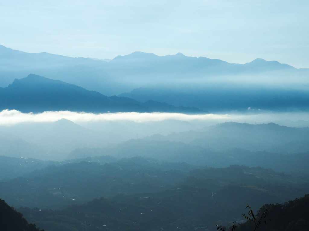
We woke up around 7:30, with plenty of time to get ready before breakfast was served at 8 o’clock. Despite the comfort of the room, I hadn’t had a great sleep, just enough to feel ready for the day. However, any vestigial tiredness was swiftly forgotten when we stepped outside to find the restaurant. The clouds of the day before had lifted (or fallen away), and in its place was a crisp blue sky. We wandered over to the viewing deck a little further up the road and were rewarded with views of a strange sea of clouds. One bright white strip lay across the land, and below it, a kind of atmospheric haze.

Breakfast was a ridiculously full spread with congee, pickles, egg and cabbage. I was absolutely stuffed after eating it, and raring to get going. After returning to our room, we packed up and Teresa headed off to work, while I set off on the next leg of the walk.


Before I did though, I decided to pay a brief visit to Shengheng Temple (聖衡宮). This grand structure had been entirely obscured by the mist when we’d arrived the day before. There wasn’t even a glimmer of its lights to hint of its presence.


I’m not even sure if it’s a single temple or multiple. If you look at the roof, you’ll see several distinct smaller temples joined together in a larger row, although only one of those can be entered, the others are all smaller. I popped into the main building to take a look and the custodian came over to have a chat. It didn’t go too smoothly though because he didn’t seem to have turned his hearing aid on.

One thing that caught my eye was this framed photo of someone’s burnt paper offering that had burnt into a crumpled form that someone deemed to resemble a deity. I did ask the custodian who, but his response was in Taiwanese so I didn’t catch it—possibly this is Guan Yu (aka Guansheng Dijon/關聖帝君), the temple’s main deity.

09:33 – By half-nine, I was ready to set of, so I headed back up past our B&B and towards the little food court where the vendors were already serving steaming ginger tea.


Two of Ginger Garden’s ginger-themed mascots.

Keep heading straight along the road, but maybe take a break to enjoy the view from the Ginger Garden carpark. Although not even an hour had passed since we saw the sea of clouds, the haze had crept further up towards where I was.

09:37 – Turn left onto a campsite track. The track cuts down past the garden of the restaurant we ate in last night.


09:39 – Keep right at the next fork. Then as you turn a bend, you’ll find the start of the trailhead proper. This is marked by an RST explainer board and an assortment of bamboo sticks. I still had the stick that I’d been given by the farmer yesterday.

Almost as soon as you’re under the trees, you’ll find another junction. Take the steps in the middle.


Light picking out details on fungus and ferns.

The trail leads first up concrete block steps, similar to the final portion of yesterday’s walk., then settles into a gentle walk along a dirt path The forest is mixed, with plenty of bamboo and the interplay of light and shadow looked for all the world like dappled, water-cast reflections on the forest floor.


10:01 – A seating area with a clear view on the left lets you enjoy expansive views of the valley below as you catch your breath. Somewhere down there is Laoguanlu and the route I walked a week earlier.

I stood there so still for so long that a flock of munias came barrelling right at me to settle on the nearby grasses, only to scatter the second I moved an inch. From somewhere far off below, the sound of Buddhist temple music came floating up to me on the crisp breeze.


10:16 – The trail dips down to a clearing where it passes over a farm track. There’s more RST signage here—this time, it’s an information board detailing how Taiwan Thousand Miles Trail Association has worked together with other groups to select, maintain and promote the Raknus Selu Trail.


The climb up from the clearing was steep and muddy and I was grateful to have my stick. There arealso lots of telltale clues to let you know that TMI Trails have worked their magic on this section. Their hand-built wood and stone are beautifully inconspicuous and are far more pleasant to walk on than the earlier concrete steps.

10:37 – A small clearing offers a partially obscured view back over towards where the walk starts. I could see the Cloud Viewing Tower perched high up on its hill, free from the cloud walls that surrounded it a day ago

And a little further up, another window opened to show me Jiali Mountain and one of the many military helicopters that seem to be a regular sight in this region.

11:15 – A vantage point with a perilous droop-off just to the right of the trail gives a broad view over towards Miaoli City. On the horizon, I could see the soupy grey fug that cloaks the west coast all winter.

As you approach the high point of the walk, the trail narrows to run through a tunnel of slender bamboo.

11:25 – I arrived at the summit of Guandao Mountain after a very leisurely climb.


From here, you can see back over to the start of the walk, and in good weather, you can see over to the Holy Ridge (聖稜線) stretching from the knobbly twins of Dabajian Shan (大霸尖山) and Xiaodajian Shan (小霸尖山) all the way up to Snow Mountain. I happened to be doing this walk on a particularly cool day in December, and there were visible patches of snow caught in some spots.


The summit has several large clear areas with benches for the large groups that presumably descend on the trail on weekends. This is a Xiao Bai Yue, so it’s undoubtedly popular on weekends and holidays. And the study summit marker informs you that you’re a full 889 metres above sea level-the highest point on the Raknus Selu Trail’s A Route (At 1,407m, Mount Manabang is the highest point on the B Route.)

11:32 – After a short break to admire the view, I continued on my way. The RST leaves the summit via a second trail on the far side to where you arrive.

11:36 – Head straight down at the next junction. The path on the right is signposted as going to Guandao Mountain East Peak (關刀山西峰) and Shengxing Station (勝興車站).


11:42 – The steps lead down to a track then head straight past an abandoned property that is fringed with poinsettia trees.

The track down to the road is broad and easy.


11:58 – Keep following the track all the way down to Miaoli District Road 56 where a roofless pavilion stands. Head straight(ish) over and take the middle one of three roads heading away from the junction.


Despite the numerous orange groves, the road is extremely quiet. Not a single car or scooter passed me. Judging by the state of some of the orange groves, not all of them are still tended to. Despite having healthy-looking trees, the fruit in this grove had been left to rot where they fell.


12:22 – Take the left at this first junction and walk in front of some farm sheds with a reservoir view. Then, five minutes later, take the fork leading down to the right. (The left road doesn’t even appear on my map.)

12:33 – As I rounded a bend, I noticed this property with enormous piles of junk accrued to either side of the road and my heart lurched. Without fail, this type of property will always have an aggressive guard dog, and usually one that’s not tied. Sure enough, as I drew closer, low grumblings became throaty growls and I could hear that it was making its way from in front of the house to come and find me. Luckily, I’d already passed the driveway entrance, so by the time grumpy doggo made it to the road, I was already safely off its property.

12:42 – Head down to the junction then cross straight over and up on Miaoli District Road 52-3 following the battered green signage pointing to Dahu, Xinkai and Zhuolan.


12:48 – There are a number of tracks branching off from Miaoli District Road 52-3. By and large, it’s easy to see where you should be going thanks to the good placement of RST signage, but not always. Here, you need to take the left-hand fork and head down past a large water tank with a great view.

Walking past this pear farm, a number of things happened in quick succession. I startled a crested goshawk into flight, which gave me a little fright because I hadn’t seen it; then, a few paces later, a pair of farm dogs began to protest my presence, their barks resounding in the otherwise quiet valley. Freshly on edge from my bird-flight fright, I emitted a small yelp, although thankfully, there was no one there to see this.


Beyond the farm, the road widens to two lanes and stays both wider and flatter for the remainder of the journey. I passed a couple of farms and holiday homes along the way. Every now and then, there were views over Liyutan Reservoir, and in the air above it, a pair of crested serpent eagles rode the air and let out their distinctive mating calls. Aside from these small points of interest, this road section wasn’t particularly special.


13:46 – Drawing close to the roar of Provincial Highway 3, the RST turns right over a bridge, then at the far end, it turns right again onto the highway.

A small land god shrine shielded from the highway by a hedge.


13:59 – The road passes Eagle Coffee (I was tempted but resisted), before splitting in two. Take the left fork and keep on Provincial Highway 3.

14:04 – A bridge decorated with a rainbow and fruit thanks you for visiting Dahu Township and once you’ve passed under it, you’re almost in Zhuolan Township.

14:05 – I arrived at the bus stop far, far too early to wait around, so instead I carried on, retracing my steps from a week earlier to climb up and over Lixiping and then down into Zhuolan. (See Day 12 via Laoguanlu for details of this.)
GETTING THERE
Public transport:
- Getting to Ginger Garden – There are no buses to or from Ginger Garden, so you’ll either need to sort out your own transport or walk this section as a two-day walk in conjunction with the previous part.
- Getting back from Xinkai – There is one bus a day in each direction that passes the end of this section. The 5655 is scheduled to pass Xinkai bound for Zhuolan at around 5pm, but since this is a rural service, that time means nothing. (The service going in the other direction runs far too early to be of any use.)
- Getting back from Zhuolan – Because Xinkai’s transportation situation is a bit pants, you might find it easier to just do as I did and walk into Zhuolan along RSA55.1-RSA55.3 (details and directions can be found towards the end of this post). The 208 leaves Zhuolan Bus Station bound for Fenguan about once an hour. Once you’ve arrived at Fenguan, you can get on the train to either north or south.
Accommodation:
Accommodation at Ginger Garden – There are quite a few hotels and B&Bs gathered in this area, most of which are a little pricey. We stayed in the cheapest room I could find at Juyuan Hakka Village.
- Name in Chinese: 菊園客家庄
- Address: 364, Miaoli County, Dahu Township, 薑麻園13號
- Contact: 037951522
- Cost: We paid $1,500 for the cheapest room they have (Room 33/Firefly Room).
- Rooms can be booked online via their website, but you’ll need to be able to transfer a deposit.
Accommodation in Zhuolan – Zhuolan doesn’t really seem to have many (or—aside from seriously expensive places on Lixiping—any) accommodation options. Luckily, getting to and from Fengyuan (which has lots of options) is pretty easy.
RAKNUS SELU DAY 12 via GINGER GARDEN TRAIL MAP
GPX file available here on Outdoor Active. (Account needed, but the free one works just fine.)
