RAKNUS SELU TRAIL – SECTIONS RSA54.2 – RSA55.3
There are two possible routes for days 11 and 12 on the Raknus Selu Trail. This post and the previous post detail the easier of the two options. This version of day 12 is both short and easy.
RAKNUS SELU STAMPS: There’s only one stamp along this secttion of the RST. You can did the RSA54 stamp at Shimen Leisure Farm. It’s kept on a table just outside the entrance to the farm’s restaurant.
DISTANCE: About 8.5 km.
TIME: I spent a little under 3 hours walking with a couple short breaks.
TOTAL ASCENT: Around 180 metres.
DIFFICULTY (REGULAR TAIWAN HIKERS): 1/10 – This is a very easy part of the RST.
DIFFICULTY (NEW HIKERS): 2-3/10 -For someone new to Taiwan, the most challenging aspect of this day’s walking would be working out the logistics of getting there.
FOOD, DRINKS & PIT STOPS: There are no convenience stores (and not much of anything else) until you reach the outskirts of Zhuolan, so you’ll have to bring what you need with you.
TRAIL SURFACES: Aside from a short section of trail and short sections on the highway, this day’s walk follows almost entirely small roads.
SHADE: Almost all of this route is pretty exposed.
MOBILE NETWORK: Phone signal is perfectly clear throughout.
SOLO HIKE-ABILITY: This section is absolutely fine for solo hikers.
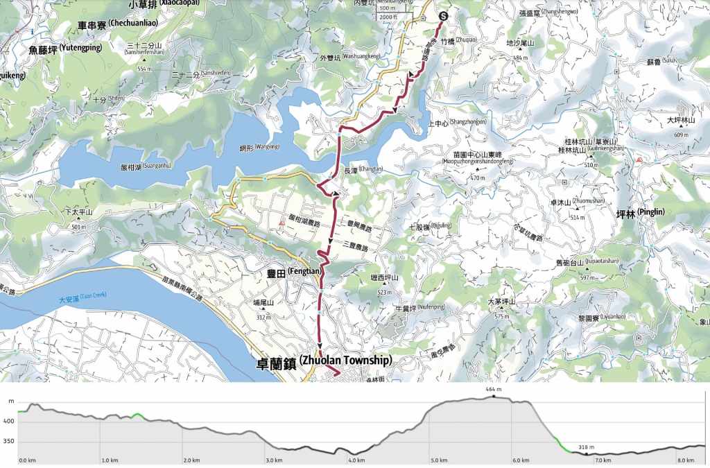
SECTIONS COVERED:
- RSA54.2: Shuiliudong Industrial Road → Xinkai Village (水流東產業道路→ 新開)
- RSA55.1: Xinkai Village → Provincial Highway 3 (新開→臺三線)
- RSA55.2: Provincial Highway 3 → Lixiping → Provincial Highway 3 (臺三線→壢西坪→臺三線)
- RSA55.3: Provincial Highway 3 → Zhuolan (臺三線→卓蘭)
Jump to the bottom of this post for a trail map, GPX file and all the other practicalities.
DETAILS & DIRECTIONS:
The curtains in the cabin I was staying in didn’t do a particularly good job of blocking out the light, so I ended up waking up at around 6:20, a full hour before my alarm had been set to wake me for breakfast. Luckily, I wasn’t too tired, so I decided to pack everything up ready to go before going down for breakfast.

I went down a few minutes early to make myself a coffee (none of the places I stayed at have coffee), and had a morning chat to the farm dogs before my breakfast was served. As with the day before, it seemed like I was probably the only guest, because it was just me and a geriatric Scottish fold cat who stalked over to say hi on very stiff legs.

08:28 – With one last farewell to the fairly well-fed yellow pup, I retraced my steps the very short distance back to where I’d left the trail, and turned left to continue my journey.

08:29 – This is still the same Laoguanlu or Old Patrol Road (老官路, also written as 老管道) as the day before, but the section of it covered on this day was all along actual roads. Despite that, I didn’t encounter a single car or scooter (being driven) for the first hour of my walk. Head straight over here.

It is pretty easy to see why this was designated a patrol road. After climbing for a few minutes, I found myself following the smooth spine of a hill with extensive views to either side of me. The haze of the morning was still hanging low over the distant hills, and the grasses beside the road were full of prinias and munias feasting themselves on the glut of newly ripe seeds.


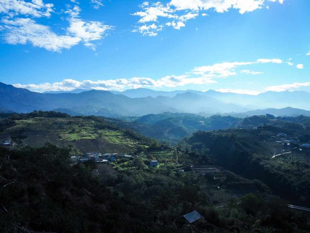
09:02 – The very best view of the day is quite easy to miss. Look out for a path heading uphill towards a wooden structure just opposite a little rest area.

From the top, you can enjoy 360-degree views of the surrounding countryside. In the east, you can see the main body of Liyutan Reservoir. In fact, you can also see the top end of the reservoir if you’re looking south. I also spotted several peaks that I have walked in the past: Mount Yuanzui is the furthest most sharp peak below the sun, and Mount Heng is just a little to the right of that.

Looking more northish, back in the direction I’d come from, Jiali Shan was decorated by thin bands of clouds and the slope seemed to rise from Jiali Shan up towards Mount Manabang (part of the RST B routes).

The journey carried on in this fashion pretty uneventfully for quite a way.

09:22 – As the name “Patrol Road” suggests, this area was not always as peaceful as it is today. In the past, this region was the site of skirmishes between different groups of Han and Hakka settlers, as well as the indigenous people who’d been here when they arrived. This stele, which was only rescued from obscurity in the overgrown depths of a pear farm in 2020, reads “擔送人夫戰死紀念碑” and commemorates the fallen Hakka soldiers who died protecting the area.

Passion fruit growing from trellises in front of Liyutan Reservoir.


09:33 – Follow the same road all the way to this junction. Here, head straightish and down past several huge chicken sheds. As I was passing through, the feed truck was emptying its contents into the grain silos and several workers were walking back and forth carrying trays of eggs.

09:38 – At the bottom of the hill, turn left to follow the road down to rejoin Provincial Highway 3.

The road takes you first under a high elevated road, then soon after that, across a bridge that’ll get you to the far side of Liyutan Reservoir.

Looking left from the bridge gives you scenes over many of the same mountains as earlier, just from a slightly different perspective.

09:52 – At the far end of the bridge, you will have crossed over into Zhuolan Township (or Jhuolan Township as it says on the sign). One of the guys in the China Telecoms van gave me a thumbs up and a “加油” as I began to climb the hill.

09:58 – A few minutes after I passed over the bridge, the RST turns left up a narrower and quieter road.


Catching my breath to look at one of the last views I’d get of the reservoir.


The road climbs and climbs until it finally levels out on a plateau that seems to have been taken over by various kinds of farms. Some offer camping, others are the kind of leisure farms where people go to take photos, and others still are actual working farms growing a variety of crops. There are more statues here of happy apples and someone called “Vanilla Sister” but nothing like the overwhelming strawberry fiesta of Dahu Township.

Scallions or something resembling scallions being bathed in jets of water.

10:28 – Follow the road straight all the way to the end where it takes a sharp turn to the right.


10:34 – A little further down, look out for these steps on the lefthand side of the road. The path is littered with pine needles, beech leaves and camphor leaves, and was a welcome break from all the road walking.


A pretty little land god temple sat part-way down the path. Inside, Tudi Gong and his wife occupied the altar.

10:41 – The steps briefly reconnect with the road at this seating area, but swiftly dive left and away from it again.


10:48 – Before long, I found myself emerging from the trees again behind another land god temple. From here, keep walking straight down towards the main road.

I crossed over here to use the bathroom at the FamilyMart, and while I was there, I decided to beat the heat by consuming a FamilyMart ice cream (I both love and hate the fact that they made most of these flavours vegetarian, it was easier not to eat too much ice cream when I didn’t have so much choice).

11:11 – Ice cream consumed, I set off again following Provincial Highway 3 again towards Zhuolan.


11:21 – At the junction, take a left to head into the town. If you want to, you can stop here at the town’s bus station.

I had a little more time on my hands, so I followed Zhongshan Road a little further into town and went to have a look at Elun Temple (卓蘭峩崙廟) and get a coffee before catching the bus back to Fengyuan from the temple bus stop.
GETTING THERE
Public transport:
- Getting to Shimen Leisure Farm – The 5655 passes the start of this day’s walk twice a day. One departs Zhuolan Bus Station at 7:40 and arrives at Jingshan Entrance bus stop around 8:20. From Dahu, it departs at 16:35, and is scheduled to pass the Jingshan Entrance bus stop around 17:00. Neither of these are particularly convenient since you’d have to first travel to Dahu by bus from Miaoli or to Dahu from Fengyuan, which is one of the reasons I decided to make this part one of my overnight stops.
- Getting back from Zhuolan – This part is easy. The 208 leaves Zhuolan Bus Station bound for Fengyuan about once an hour. Once you’ve arrived at Fenguan, you can get on the train to either north or south.
Accommodation:
Accommodation in Dahu Township – You’ve got lots of options in this area, particularly if you fancy some (expensive) glamping. I stayed in a wooden room at Shimen Leisure Farm—one of the six Raknus Selu Trail Workstations. My room was clean, comfortable, and quiet. In fact, I think I was the only guest on a cold December night.
- Name in Chinese: 石門客棧休閒農場
- Address: 36442, Miaoli County, Dahu Township, 竹橋20號
- Contact: 037951129
- Cost: I paid $1,600. I was quoted a higher price for two people, so I think part of the room price was knocked off because they only needed to prepare breakfast for one.
Accommodation in Zhuolan – Zhuolan doesn’t really seem to have many (or—aside from seriously expensive places on Lixiping—any) accommodation options. Luckily, getting to and from Fengyuan (which has lots of options) is pretty easy.
RAKNUS SELU DAY 12 via LAOGUANLU TRAIL MAP
GPX file available here on Outdoor Active. (Account needed, but the free one works just fine.)
