
Mount Jinganshu and Wangyou Forest
(Updated Mach 2025)
The last time we were in the area around this trail was a year or two ago when we visited nearby Phoenix Mountain (another of the Xiaobaiyue). As with that walk, I finished the day thinking that I really ought to spend more time walking in this part of Taiwan. The scenery is beautiful, full of plant and bird life, and the elevation makes it a great place to wander year-round. It is certainly one of the more varied Xiaobaiyue trails that I’ve walked to date and is up there with Yunlin’s Dajian Shan as being one of my favourites so far.
DISTANCE: 6.6km – There are options to extend or shorten this in a couple of spots.
TIME: 4½-6 hours – It took us a little over five hours, but I think I would have been a little faster if I’d been walking solo.
TOTAL ASCENT: About 330 metres, the bulk of which is done in one push at the start. Having said that, it certainly felt like more of a sustained climb.
DIFFICULTY (REGULAR TAIWAN HIKERS): 3-4/10 – Route finding and climbing should be tiring but not difficult for people familiar with Taiwan’s trails. I found this walk to be on the easy end of moderate.
DIFFICULTY (NEW HIKERS): 5-6/10 – Some steep climbs and very basic signage would put this on the upper end of moderate for a new Taiwan hiker. Doable, but give yourself plenty of time.
SIGNAGE: There’s only hand-written Chinese signage the whole way, so it’s advisable to take a map and/or download a GPX route. (Obviously, it’s always advisable to take a map of some kind, but doubly for routes like this.)
FOOD AND WATER: Although we went in June, it was not hot and we got away with about 0.7L each. Food-wise, we took nuts, biscuits and some salt candy.
SHADE: This trail is wonderfully shaded almost the whole way. Despite it being an on-and-off sunny day, I didn’t need to crack out the umbrella or sun hat. It’s the perfect summer walk.
MOBILE NETWORK: Mobile reception was patchy.
ENJOYMENT: I loved this walk. There are so many different types of forest scenery to enjoy, from tea plantations to towering bamboo and cedar forests, as well as a beautiful earthquake lake. If that’s not enough, there is also a great amount of birdlife in the forests here. Our whole walk was soundtracked by Steere’s liocichla and white-eared sibia calls.
SOLO HIKE-ABILITY: If you’re confident with route finding, there’s nothing to stop you doing this walk alone.
OTHER: I didn’t take a hiking stick, but it would have been helpful. Also, it’s worth pointing out that the temperature difference between here and the cities. At the time of our visit, Taipei was sweltering in 35°C heat, but the temperature at the peak was a perfectly comfortable 18.°C. In the summer, the only difference this makes is that the weather is comfortable to walk, but in the winter, you’d need to be a little more careful about being prepared for the cold.
TAIWAN 100 MINOR PEAKS: Number 54 – Mount Jinganshu
ROUTE TYPE: There and back.
PERMIT: None needed.
Jump to the bottom of this post for a trail map and GPX file.
DIRECTIONS:

It probably does this walk a disservice if I tell you that this view, which is right at the very start of the trail, is the most impressive of the whole route. It’s true, but what lies ahead are beautiful forest views instead of sweeping landscape vistas like this.


08:25 – The trailhead can be found close to a bus stop on a bend. There’s an abandoned brick building just inside the treeline.

From memory, although there are other steep sections, this is the longest sustained upwards slog.

08:38 – Ten to fifteen minutes into the walk, the trail emerges at the edge of a tea plantation.


Rows and rows of tea bushes are stacked ever higher IP a vertiginously steep slope, and bobbing amongst them were the behatted heads of a leaf-picking team.


The path follows the edge of the tea plantation upwards for about ten minutes before ducking back under the trees again.

09:00 – At the top of the tea farm, the trail turns left onto a farming track.

A sign at the junction has been painted with characters asking hikers not to use the land as a toilet, so I imagine the farmers have not always enjoyed smooth relations with hikers.


09:03 – Follow the track down to the next junction and take a left turn (later on, the walk will loop back to this point). Just beyond the junction, you can choose to either follow a path on the right up through the trees, or stick with the track. Either way, the two options will connect up again in a minute or two.


Where the track turns a bend, there is a trail marked “菇菇大道” (Mushroom Boulevard?). Some people follow this, but we decided to stick with the track a little longer.

The track terminates at a tea pickers’ storage hut and from here, the trail disappears straight into the trees.


Straight away, we were swallowed up by the forest.

In amongst the cedars are the skeletons of some of the forests’ old giants.


And on the smaller end of the scale, there were numerous clumps of Indian ghost pipes and scores of mushrooms in all sorts of different shapes, sizes and colours.

09:42 – We connected up with another trail joining from the left. Veer right here and cut around a swampy clearing.

We had been alone for while, but around this point, we could start to hear groups of hikers walking on one of the parallel trails.


09:50 – The path climbs up to a junction. A fork with some signs just to the right of where we arrived indicated that the summit of Mount Lingtou was just a 1-minute walk to the right, but that the main trail onwards to Mount Jinganshu was on the left.

09:52 – Since we were up there already, we made the brief detour to see the summit


Heading back to the previous junction and took the other trail leading onwards towards Mount Jinganshu. Soon the trail takes a right to join up with another of the many routes riddling the area—this one seemed to be the most popular route, because as soon as we joined it, we were surrounded by hikers in other groups.

On the descent, we met another couple who seemed to have no idea of which way they needed to be going. Hopefully, the sheer volume of people of the route will have prevented them from getting lost.


10:03 – The path tracks down to another of the swampy clearings that seem to characterise this patch of forest.


10:09 – Then it climbs up again to another junction. To head towards Mount Jinganshu, turn left here. (Later, we would return to this spot and take the other trail on the right.)

10:13 – A short distance away from the junction there is a clearing where several benches have been fashioned in a ring beside a mini giant tree (it’s big, but not especially big by giant tree standards).

Some more of the vibrantly spectacular fungal variety on the trail. This region is known for its perpetual afternoon mists, which means the leaf litter is kept nicely moist and life like this can thrive.

Speaking of moistness, we got our first taste of the atmospheric cloud forest right around the point where the trail dipped to cross a cleft in the landscape, affording us this enchanting view of walkers climbing towards the luminous cloud forest.

10:25 – At the next junction, keep right. (The trail on the left is marked on my map as being the Southern Ridge Route or 南嶺線, and tracks down into Xitou Nature Education Centre. In fact, following this could take you all the way to Phoenix Mountain.)

10:27 – At another junction, the trail to Mount Jinganshu heads straight over Mount Lingtou East Peak. The trail on the right is a continuation of the Southern Ridge Route, and is signposted as going to Juying Village (聚英村.)

10:29 – At the next fork in the trail, take the lower left path skirting around a rise in the land. (We initially went the same way as the group heading straight up, but this trail leads up to the remains of an old hunters’ camp and then terminates.)


This stretch is very pleasant. The climbs are all gentle enough that you never feel too tired, and the forest feels bright and vibrant.

Up here, there are more sections of enchanting bamboo forest.


10:50 – A second junction on the right leads down towards Juying Village. Ignore it and head straight once more, passing Mount Jinguanshu Northwest Peak.

11:03 – There’s one final junction before the summit—this one leading down to the left and towards Xitou Nature Education Area. Once more, head straight (and probably towards the sound of people enjoying a break).

11:06 – At 2091m in elevation, this is the sixth highest of Taiwan’s Xiao Bai yue (or Minor 100 Peaks). As with quite a lot of these summit markers, the picture reflects the peak’s name, since “金柑樹” means “Kumquat Tree”. Somehow, I don’t think Kumquat Tree Mountain sounds very impressive. I think I’ll stick with Mount Jinganshu.

There’s a spacious clearing at the summit with plenty of seating for people to stop and take a break. However, we knew that there was an especially large and loud hiking group following a few minutes behind us, so we decided to retreat the same way we’d come and find a quiet spot to enjoy a snack.

We took a 20-minute break and resumed our downhill journey at around 11:30ish. Although we were following the same trail back, the onset of the noon mists made the landscape feel entirely new.


At each junction, we kept retracing our steps, back the same way that we’d come.

Although we’d been walking up with a couple of groups, most of our return journey was spent alone.

One of the more spectacular mist and bamboo-filled clefts in the hills.

12:15 – About 45 minutes after we began our descent, we arrived back at this junction. To visit Wangyou Forest (忘憂森林), head straight over. (When we walked up, we came via the trail on the right.)

A bright orange mushroom tucked just below one of the steps. The trail climbs briefly up towards a clearing, then starts to descend once more.

12:23 – At this junction, veer slightly to the right. I didn’t take so many photos along this stretch, but it alternates between steep descents and a pretty wooded ridge.


12:42 – Teresa decided to turn right and head downhill at the next junction. In fact, both routes will join up again around the lake, but I think the route we took is the most traversed of the bunch.

Once you hit the stream, turn left and walk through a light, grassy patch of forest following the direction of the water. We saw so many little birds in this section, including a pair of Taiwan barwings, which I think I’d only ever seen once before.

12:48 – I knew that the walk was going to take us past an earthquake lake, but the sight of it was still enough to take my breath away.

Formed as a result of the devastating earthquake that rattled Taiwan on September 21, 1999, the spring-fed pool has become an important aquatic habitat.


Not least for the numerous frog species that have populated the water with tadpoles in all sizes from tiny to humungous.

Even in quite mundane weather conditions, the scenery is undeniably beautiful, but photos of the spot on misty mornings make it look positively otherwordly. (I also think we were lucky to see it so full of water, it’s not half as impressive when the trees are just sat in mud.)

Despite its remoteness, we encountered quite a lot of people at the lake, including lots of families with young kids and people who had not dressed for a hike.


13:08 – The trail follows the edge of the pool down some rickety metal steps and out of the forest towards the edge of the tea plantations. An incongruously located coffee and tea shop was doing a roaring trade. I would have loved a coffee, but they seemed to be using only disposable containers and I’m really trying my hardest to avoid single-use containers where possible.

Just down from the coffee shop, the reason for there being so many non-hikers became apparent—some enterprising locals with vans ferry people up and down the hill for $100 a pop in each direction. If you’ve still got energy to walk, turn right onto the farm track.


At the next junction, take the lower righthand trail again, then almost straight away, you’ll find yourself at another junction which should be familiar, turn left here and follow the track uphill. Soon, you’ll find yourself back at the “no peeing or pooing” sign that marks the start of the tea farms.

The clouds had well and truly descended on the land by the time we were making our way back down the rows of tea.

13:42 – We arrived back at the trailhead about 20 minutes before my self-imposed time limit (there was a higher chance of rain in the late afternoon), and returned to the car to boil up some water for a coffee. As we were driving back down the hill about an hour and a half later, the heavens opened and we were drenched by one of the heaviest storms I have witnessed so far this year.
HOW TO GET TO MOUNT JINGANSHU
Google Maps address: The walk starts from Liulongtou bus stop. There is a reasonable amount of roadside parking here.
GPS location: N23 39.320 E120 47.330
Public transport:
- Getting to the trail – Getting here has become a little more complicated since the 6871 Yuanlin bus to Shanlinxi (more commonly known as Sun Link Sea/衫林溪) has been discontinued. Now, the only bus that passes this trailhead is the 6883B from Taichung TRA or HSR station to Shanlinxi. However, a helpful reader has advised me that it is only possible to book a ticket for this bus is you have proof of accommodation at Sun Link Sea. He got around this problem by taking the regular 6883 to Xitou and changing to the 6883B from there and alighting at the Wangyou Forest bus stop. It takes 2.5-3 hours to reach the trailhead so you really want to be on the earliest possible service to ensure you have enough time to complete the walk.
- Getting home – The 6883B leaves Shanlinxi three times a day (11:00, 14:50, and 15:45) and arrives at Wangyou Forest bus stop a few minutes later.
Further reading: So far, this doesn’t seem to have any other English info out there, but there’s plenty written on the subject in Chinese. This post has loads of pictures to tempt you.
MOUNT JINGANSHU TRAIL MAP
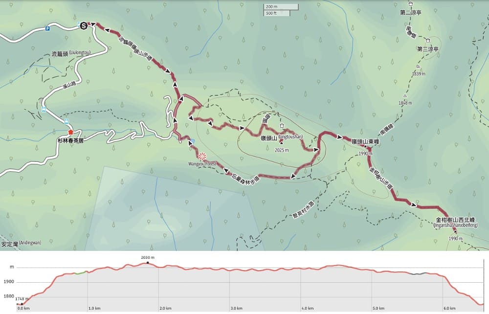
GPX file available here on Outdoor Active. (Account needed, but the free one works just fine.)
