
A Historic Trail with Tea Plantations and a Unique Christian Shrine
When hiking in Taiwan’s hills and countryside, it’s very common to come across temples dedicated to gods, spirits and enlightened beings from the Buddhist and Taoist belief system. What’s less common (unless you’re in aboriginal areas), is to find a Catholic shrine—especially one that’s been decked out to resemble Lourdes. This walk is also section RSB06-1 of the Raknus Selu Trail’s B Route.
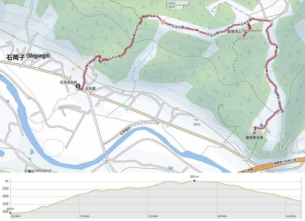
Distance: 4.6km from trailhead to trailhead, or 6.1km if you loop back along the road.
Time: About 2 hours.
Difficulty (regular Taiwan hiker): 2/10 – Some steps, few clear signs, but otherwise easy.
Difficulty (new Taiwan hiker): 3/10 – This should be a pretty easy trail even for an inexperienced hiker.
Total ascent: A little over 200m.
Water: I took a 0.5L bottle of water and some coffee. I also took snacks, but it’s not essential. There’s a convenience store close to the start of the trail where you can pick up supplies if necessary.
Shade: I needed to take an umbrella—there are plenty of stretches with little to no shade.
Mobile network: Signal was pretty clear throughout.
Enjoyment: I really enjoyed this trail. It’s short and sweet, it has a nice little section of historic trail, and the bizarre church near the end was pretty cool too.
Route type: Point to point or loop.
Permit: None needed.
Jump to the bottom of this post for a trail map and GPX file.

The bus journey from Hsinchu Main Station took a little longer than expected due to the morning traffic, and bizarrely, the stops were only announced in English over the speaker (Chinese speakers had to read the scrolling sign). When we arrived at Shiguang Village, I was a little thrown by the bus company’s odd choice of translation and pronunciation. Rather than going with the standard “Next stop: Shiguang”, they went with some hybrid and ended up with “Next stop: Shee Light”. (Good luck to anyone who has just arrived in Taiwan! You’re better off just watching the point on the map to see when you’ve arrived.)


Me and a grandma laden with her shopping bags were the only two people to alight here. She nodded at me bemusedly before scurrying down the road. If you need provisions, head to the 7-Eleven just a little further up the road. If not, head under the raised water channel, then take a left and climb up the stairs just on the far side of it. At the top of the steps, the road passes Shiguang Community Development Association. Inside, an older woman was having her eyebrows neatened up.

Looking back at the association’s building, I spotted this cheery mural depicting tomatoes growing in sunny fields.


The road splits around the boxed-in water channel; either left or right is ok, but you’ll have to cross the water at some point. On the left, I passed Shiguang Junior High School, and then shortly afterwards, the road passes over the water again. There are characters reading “石光古道” directing you over the bridge and along the old trail.

Just over the far side of the bridge, there’s a beautiful red-brick sanheyuan (a style of dwelling with three wings flanking a courtyard). Characters above the door pronounce it as being Yuzhang Hall (豫章堂), and information online suggests that it has belonged to the Luo family for generations. It looked like Mr Luo was around. Clothes had been laid out on the scooter to dry, and there were the sounds of tinkering coming from a workshop just to the left of the house, but I didn’t see anyone.


Where the trail starts to lead away from the house, there is an old pig pen with a couple of pigs made from thick cords of unravelling hemp rope.


The “historic trail flavour” is pretty strong on this walk. Much of the path is made up of local stones, with larger stone steps tucked into place by smaller stones on either side. I’m sure it’s been repaired over the years, but this was a pretty popular method of trail construction in the past, and you can still find it on many old trails.

I climbed for a little under ten minutes before reaching this pavilion. It seemed weirdly desolate. Something about the spacing or size of the benches felt off. I didn’t stop long.

There’s some more climbing, nothing too strenuous, and before you know it, the trail starts to level off. I passed a turn-off on the left here which heads to Dadongkeng Shan (大東坑山) but I hadn’t come equipped for an extra kilometre of scrubby trail, so I stuck to the wonderfully relaxed main route.


Even though the route was very tame, I was still rewarded with some impressive minibeast sightings. On the left is a multicoloured Saint Andrew’s Cross Spider. And on the right is the dazzling caterpillar form of the rather drab-looking white commodore butterfly.

The trail reaches a clearing which has views over the southern hills. It wasn’t especially clear when I visited, but in theory, you should be able to see Mount Ergongji and plenty of others from here. While I was here, a helicopter flew down the valley. I’d been hearing one buzzing around the whole time I’d been climbing, but I didn’t manage to make out any markings on it.


Beyond the clearing, the trail becomes more of a track, and there are signs of past farming or habitation in the area.

Peak baggers might want to look out for the hiking tags on the right here which indicate the turn of for Mianpuding Shan (面埔頂山). Since the summit was only about 150m off the main trail, and the path looked easy enough, I decided to take a look.

I’m glad I did. It was a pretty little addition to the walk and I saw more bird life on this short section than I did on the whole of the rest of the trail. (Black-naped monarchs and Morisson’s fulvettas to name two of the species I could identify.)

The peak itself though was not very noteworthy. There is a trail which cuts directly back down from here to the town, but it looks rather infrequently walked, and it would skip the part of the trail that I was most keen to visit. So…

I returned to the main trail and followed it until it reached a junction. Take a right here and head towards the main road. Actually, it’s more of a country lane than a main road, but still more of a road than the track I had been on.


The track lets out onto tea fields, and I suddenly found myself flanked by rows of tea separated by bright red earth. At the end of the track, there’s a pavilion where I took a short (early) lunch break, before taking a right turn and starting to follow the road downhill.

At the next junction, turn right again, this time following the sign reading “露德聖母山莊” which directs you towards the Christian Shrine.

This next bit of road was quite pretty. There were more rows of tea, as well as other fields full with trellises laden with fattening dragon fruit.


Then the road suddenly seems to reach a dead-end. Its still a little further to go though. Just follow it as it curves right, head past a couple of houses and a large chicken coop, then you’ll find yourself at the rear of the shrine.

An arched roof has been erected to shelter the shrine’s congregants from the worst of the elements, but it still feels wonderfully open.
Built 100 years after Bernadette Soubirous witnessed her 1858 vision of the Virgin Mary, Xinpu’s Church of Our Lady of Lourdes is a replica of the more famous one in Lourdes… just with a lot more tilework. A lectern stands beside a tiled altar and tiles seats are arranged in gently curving arcs facing the “cave”. As in the original, Mary stands in an alcove above the dais, facing her devotees.


I stayed a while, enjoying the atmosphere of the place and watching these young wasps emerge leave their nest.

The trail continues down some steps which lead away opposite the entrance to the shrine. A map pasted on the wall there shows the locations of other Catholic churches across northern Taiwan.


There’s an old mud-brick building, and more religious iconography to see you on your way.

The steps are a little slippery though, so watch your footing as you head down.


The sound of the traffic gradually grew louder, and I found myself crossing a stream and rejoining the road less than ten minutes after I left the shrine. There’s a bus stop right next to the trailhead, so if you’ve had enough walking, you can plop yourself down to wait. But it seemed like I had enough time to walk back to where I’d started before the bus came, so I turned right onto the road and walked past strawberry farms and a few old buildings, all the way back to Shiguang (and a cold drink from the convenience store).
How to get to Shiguang Historic Trail
Google Maps address: Shiguang Historic Trail starts from close to the bus stop on Shigangzi Road. There is not much in the way of formal parking around here, but if you drive up and down the road a bit, you’d probably find somewhere to pull up.
GPS location:
Public transport: From the bus stop outside Hsinchu TRA Station you can catch the 5619 via Xinpu or the 5620 via Guanxi and alight at Shiguang. Turn right out of the station and walk about 50m to the bus station. (I think the 5619 also runs past Zhubei TRA Station if you’re coming from the other side.)
Further reading:
- Western trailhead (by the village) – N24 48.900 E121 07.830
- Eastern trailhead (by the chapel) – N24 48.430 E121 08.655
Nearby trails:
- Raknus Selu Trail Day 2
- Raknus Selu Trail Day 3
- Raknus Selu Trail Day 3 via Bailing Pavilion
- Raknus Selu Trail B Route – Lianhua Temple to Guanxi
- Xinpu Wander
Shiguang Historic Trail Map
GPX file available here on Outdoor Active. (Account needed, but the free one works just fine.)
