
A last-minute free day on the first day of the Mid-Autumn Festival long weekend led to a return visit to this little peak just south of Yehliu Geopark. I’d attempted it once before but had been thwarted part-way by a territorial hornet fiercely guarding one section of the trail. Thankfully, it seems that even guard hornets had the weekend off, and this time we were able to complete the loop with minimal bug-induced worries.
At first, I was worried that I’d not picked the right trip for our impromptu wander, but in the end it was perfect. It starts with a fun ridge/cliff scramble accompanied by lovely coastal views, then cuts along the rear end of the hill before doubling back to track through the fishing village of Yehliu. Here you can stop for sustenance, enjoy views of the harbour, and scramble up to observe the odd carved knob of the Camel’s Hump.
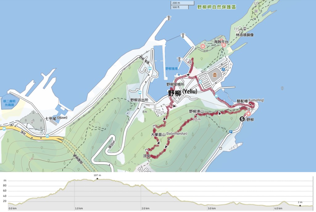
Distance: 4.6km
Time: 2-3 hours – We we’re back down on the road within an hour and forty minutes, but some detours once we were back in the town took that up to three hours.
Difficulty (regular Taiwan hiker): 2-3/10 – For the steep cliff side scramble, the rest is a breeze.
Difficulty (new Taiwan hiker): 4-5/10 – The lack of signage at the start would have alarmed me when I was starting out. The climb is steep, but not exceedingly so, and it’s short.
Total ascent: A little over 110m.
Water: I didn’t quite finish my 0.5L bottle.
Shade: Some parts are entirely exposed, others are well covered. We both had hats and long sleeves to keep the worst of the sun off.
Mobile network: Clear throughout.
Enjoyment: This is the perfect little walk. Views, fun climbing, a coffee shop on the way back, a couple of interesting buildings, somewhere to sit and watch the ocean. The only thing I would have done differently is to bring the coffees to Camel Mound and sip them as we watched the waves dash themselves on the rocks.
Other: We came across quite a large number of golden orb weavers on this walk. For seasoned Taiwan hikers, these guys are just part of the experience, but their fearsome-looking size can be alarming to the uninitiated. However, pretty much without exception, their webs had been partially cleared by other hikers so we just had to duck a little to pass under them. These guys will react pretty quick if you accidentally tap their webs (which we did several times), but their reaction is just to retreat to the uppermost portion of their webs and wait for you to leave them alone. They won’t drop on you or jump and although they can bite, they don’t unless you are grabbing them.
Route type: Loop
Permit: None needed.
Jump to the bottom of this post for a trail map and GPX file.

The walk starts precisely at the point where the road cuts a channel through the weather-worn sandstone. Later, we would return to scramble up past the advert for the Queen’s Head (Yehliu Geopark’s most iconic character), but first, we turned left and started the scramble up the slanting cliff, running from the sea all the way up to Yehliu Port Hill.

The first ten metres or so don’t have a defined trail, but after scanning the slope ahead of us, I spotted the ropes hanging against the rock and indicating the start of a 500-metre climb.


This first part of the trail is quite like most of the walks I’ve done in and around Taipei on account of the combination of exposed sandstone surfaces and proximity to the ocean.

We saw several of these blackberry lilies (also known as leopard lilies) beside the trail.

Each time there was a point to stop and observe the view, we did so. Each vantage point offers a slightly new view of Tung-ao Fishing Harbour and the spit of land occupied by the geopark.

The path hugs close to the edge of the cliff but rarely gets close enough to feel risky. At points, the summit we were aiming for was clearly visible up ahead, and at others, it gets lost in the mess of spider webs and scrubby tree growth.

As we made our way higher, accumulating sweat, grime and spider webs, it seemed as if the water was beckoning to us. What type of fool heads up a hill and away from the bluer-than-blue water when the weather is hot and sunny like this?

About halfway up, there’s a protruding rock that is just asking to be photographed (carefully, of course). Later on, as we made our way back up the road, we think we spotted it sticking out precariously. It would be pretty cool to have photos from both sides.

Some sections of the trail duck into the tree cover, making the spider webs harder to see (if not less abundant).


About 100m from the top we encountered the steepest of the rope-assisted climbing sections. Looking back and watching K climb, I saw Keelung Islet floating on the horizon a couple of kilometres off the coast.

At the top of another short, steep climb, we got the last view before the trail ducked under the treeline for good. That’s not to say there were no views to be had from here on out, just they became occasional rather than constant.

We arrived at the peak a leisurely 45 minutes after setting off. Yehliu Port Hill is a mere 110m above sea level, so definitely more of a hill than a mountain, but if there was a little less tree cover, it would have stunning views up and down the coast. We paused a while to have a little snack here before continuing on our way.

Hunger staved off with tofu cubes, we followed the trail leading inland and along the tree-covered ridge line.

Part way along, we passed the remains of an old military bunker… obviously I wasn’t the only one to think the hill offered good views. There are probably bunkers like this on a lot of the hills along this stretch of coastline. I’ve seen them at nearby Jinshan Shitoushan Park, and the peaks closer to Keelung are positively riddled with military relics.

One of the tree windows offered a pretty view looking further north.

Another window had a great vantage point looking down towards Yehliu Fishing Harbour. (There are two separate fishing ports , one located on either side of Yehliu Geopark.) This is where the trail descends to.


The final little stretch of dirt trail gets a bit steep again. Steep and slippery. It’s clear that this end doesn’t get so much sunlight since many of the rocks are covered in a thin layer of slippery green algae.

Almost too soon, we found ourselves arriving on a more established trail. Here we took a right turn and followed the steps downhill through the shade.


This section of the trail is far less interesting than the climb up, but we did spend a few minutes stopped to observe a mixed flock of Taiwan barbets, rufous-capped babblers, black-naped monarchs, and Taiwan scimitar babblers. (Why do these always seem to hang around together? Is it purely related to food sources?)


The steps track down to a small grassy area with a pavilion. Take a right turn at the lamppost and head down another several metres of steps.

People who’re into their old buildings should take a brief right at the bottom of the steps to take a look at this lovely old stonework.

Then take a left and head through the narrow alleyways towards the main road.

When we’d made our way back down to Gangdong Road and took a right turn and started to making our way back to the scooter, but got a little sidetracked by the promise of iced coffee from 85°C.

Coffee, it transpired, was a very good choice. We sat outside and drank it to cool down before heading ok our way. We made one final detour to top up water bottles at Renhe Temple and admire the opposite view of the harbour. (That slope on the far left is where we came down.)

We made our way back around the parking lot for Yehliu Geopark, past all the restaurants with overenthusiastic staff trying to drag you in for some seafood.


When we got back to the bend in the road where our walk started, we clambered up on the shoreward side and made our way through the straggly screw pine to where the rocks are exposed to the wind and the waves.

If you make your way up to the topmost point, you’ll find this odd little structure carved out of the soft, beautifully patterned sandstone.

It’s big enough for several people to squeeze inside, although even without my exit blocked by another person, I couldn’t stay inside too long.

How to get to Yehliu
Google Maps address: The walk starts immediately opposite the Camel’s Hump. There’s free roadside parking for a few cars and scooters on the side of the mound away from Yehliu.
GPS location:
- Camel’s Hump trailhead – N25 12.155 E121 41.660
- Yehliu Harbour trailhead – N25 12.170 E121 41.265
Public transport: Hop on the 953 Shuttle bus bound for Jinshan from National Taipei University of Technology and ride it to Dong Ao. You’ll have to walk a couple of minutes to the trailhead.
Further reading: Somewhat shockingly, there aren’t any English descriptions out there that I can find. This walk deserves to be better known than it is. There are plenty of Chinese write-ups though. Like this one, or this one which does the route in reverse.
Nearby trails:
Yehliu Port Hill Trail Map
GPX file available here on Outdoor Active. (Account needed, but the free one works just fine.)

This looks nice. I was going to say it might be a nice one for a family hike until I saw the part about it being steep and there being lots of spiders.
LikeLiked by 1 person
The spiders are definitely seasonal. They were worse in the summer than later in the year. As for the family-friendliness or otherwise, if you do part of this walk in reverse, (as in head up the steps to the ridge and then head back the same way), it could be suitable for most kids. You’d get some of the views too. However, I wouldn’t recommend the whole loop for little children, especially if you’re not 100% confident in their ability to stop and listen to your instruction. The reason for this isn’t so much the steepness (I’ve seen plenty of monkey-like children on similar trails), but mote because there are a couple of places where it could be dangerous and they would need to understand that.
LikeLike