
RAKNUS SELU TRAIL – SECTIONS RSA31.2 – RSA38.1
We picked up our Raknus Selu journey with a two-night, two-day section walk over Qingming Festival. With temperatures starting to creep up, it is becoming increasingly uncomfortable to walk long distances and keep walking through the middle of the day. I get the feeling that either I’m going to be hiking on my own for a bit, or else we’re going to have to pick this back up again come autumn. This day connects Sanwan with Mingde Reservoir, and although quite a long walk, it’s not too hard, and has a nice mix of trails and lanes.
RAKNUS SELU STAMPS:
- RSA32: Located in a convenience store at No. 221 Zhongzheng Road
- RSA34: Located in Sanwan Li Township Leisure Agricultural Area Tourist Service Centre
- RSA37: Located in Baishou Village Land God Temple
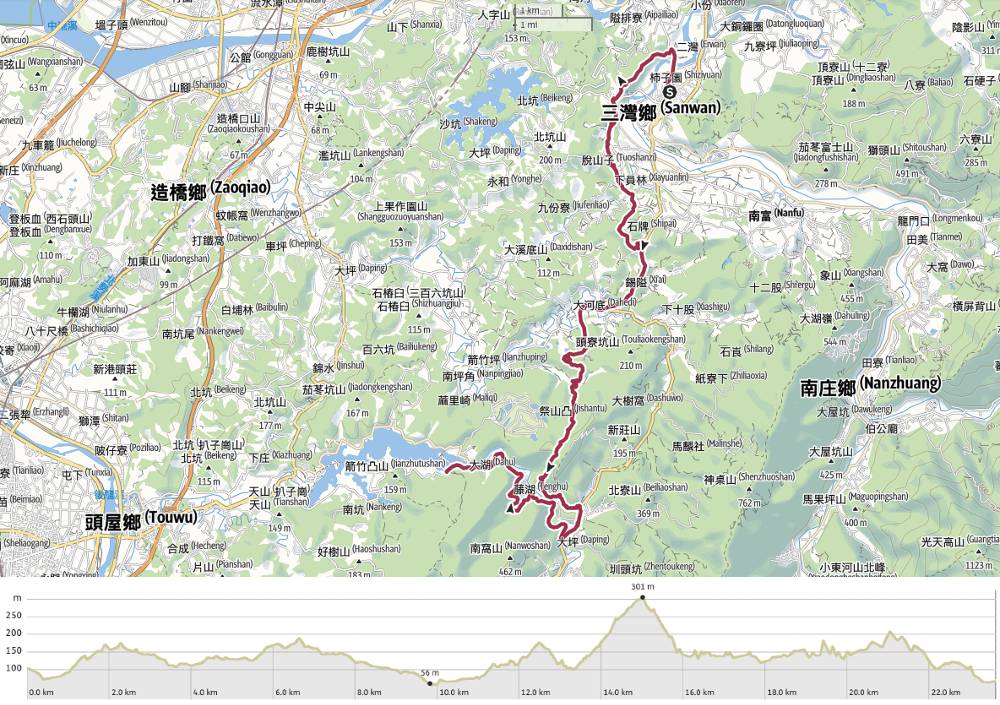
DISTANCE: 23.6km
TIME: 7-9 hours. It took the pair of us 8½ hours. I think I would have been about an hour quicker if I’d been on my own.
TOTAL ASCENT: About 670 metres.
DIFFICULTY (REGULAR TAIWAN HIKERS): 4/10 – On the harder end of easy. Quite honestly, the mental endurance required to finish this in warm weather (around 25°C) was by far the hardest part. It’s quite a long way and the elevation gain is reasonable, but the trail itself is straightforward and easygoing.
DIFFICULTY (NEW HIKERS): 6-7/10 – I’d put this on the harder end of moderate for newer hikers. No one bit of it is difficult, but the combination of everything mentioned above would make it a little too challenging to be pleasant.
FOOD, DRINKS & PIT STOPS: We took about a litre each (which wasn’t quite enough), as well as bread, tofu, and snack bars. There are convenience stores at the start in Sanwan, but that’s it for the whole of the walk. We should have taken salt candy too, but this was our first warm weather walk of the year and I forgot. And if you’re planning on staying overnight at Mingde Reservoir as we did, you’ll certainly have to take lunch supplies for the following day. (And check that wherever you choose to spend the night will sort you out with dinner and breakfast.)
TRAIL SURFACES: Everything! We covered roads, bikeways, farm tracks, paved trails, and dirt paths.
SHADE: Plenty of patches where you’d need protection from the sun on a bright day.
MOBILE NETWORK: Mostly OK, with just a couple of black spots on RSA36-37.
SOLO HIKE-ABILITY: There’s nothing about this walk that would make me think twice about walking alone.
OTHER: Softer-soled shoes will make the long road sections more comfortable.
SECTIONS COVERED:
- RSA31.2: Sanwan Town Centre → Longending Trail Entrance (三灣市→龍峎訂步道口)
- RSA32: Longending Trail (龍峎訂步道)
- RSA33: Longending Trail → Neibu Road → Sanlianpi Bike Path → Miaoli District Road 5 → Old Gun Locker Trail Entrance (龍峎訂步道→ 內埔道→三連埤自行車道→苗5→老銃櫃步道口)
- RSA34: Old Gun Locker Trail (老銃櫃步道口)
- RSA35.1: Provincial Highway 3 → Dahe Community → Miaoli District Road 14 (臺三線→大河社區→苗14)
- RSA35.2: Miaoli District Road 14 → Mount Erliaokeng Trail Entrance (苗14→二寮坑山徑口)
- RSA36: Mount Erliaokeng Trail → Zhihu Historic Trail (二寮坑山徑→紙湖古道)
- RSA37: Zhihu Historic Trail (紙湖古道)
- RSA38.1 Zhihu Historic Trail Entrance → Zhupaitan → County Highway 126 → Miaoli District Road 16 (紙湖古道口→竹排潭→縣道126→苗16)
Jump to the bottom of this post for a trail map, GPX file and all the other practicalities.
DETAILS & DIRECTIONS:

8:47 – The bus dropped us off outside Sanwan Post Office a little before 9am. It was later than we’d hoped (bus timetables not being especially accurate in this part of the world), but not too bad. We’d already prepared everything we needed though, so we set off straight away. If you want to collect the passport stamps, make sure to head on a bit until you reach No. 221 Zhongzheng Road, but if you’re itching to get started, then take a right turn onto Minzhi Street (民治街).


The road takes you out of Sanwan and down towards Nanzhuang River. If you’re feeling brave, glance up to your left at the exposed cliff running along the far bank of the river. That’s the first climb of the day. (But it is far from the last.)

9:03 – The RST takes a left turn away from the road and onto the first footpath of the day. This is the start of Longending Trail (龍峎訂步道).

The tone for the day’s scenery was set early on. Longending Trail cuts a path through bamboo-covered slopes, something we would see lots more of later on too. In a couple of places, there were gaps in the trees through which we were able to Sanwan looking quiet amidst the morning haze.


We passed a woman with a very timid white dog. She was walking up and down the trail for exercise and was walking far quicker than us. Each time she passed us, her dog hung back until it thought it was safe enough to pass. The woman said she used to be a stray and didn’t trust anyone. Close to where the trail starts to head down, a rough trail on the left cuts up to the top of a small hill. This is the third Mount Huoyan (火炎山) I’ve encountered in Taiwan.

9:44 – At the bottom of the steps, turn left onto Neibu Road. We followed that through farmland until arriving at the junction by a Buddhist temple. There was much chanting going on and we snuck in the back to make use of the toilets before carrying on.


10:02 – Cross straight(ish) over and continue heading downhill.


10:14 – A brief detour on the right took us to these Grandma and Grandpa trees. The larger of the pair (the grandpa tree) is a camphor tree that has stood in the village for over a hundred years, and the grandma is a wax apple tree that was in brilliant bloom when we passed through.

As we approached a junction, the strange sight of an escaped zoo’s worth of animals greeted us. They were gathered in a small park beside a pond.

Teresa sizing up a giraffe.


10:22 – With the pond on your right, turn right onto the road, then almost immediately take a left turn and head up to join Sanlianpi Bikeaway.

The bikeway is quite pretty in a rural sort of way. On the right, there’s bamboo-covered slopes, and on the left, we could see over farmland to houses beyond.


We saw a lesser coucal dive into the grass, and watched cattle egrets waiting for a farmer to till the earth. There are also quite a few well-looked-after graves up here.


10:45 – Head straight over and past another small lake.

10:48 – Where the bikeway rejoins the road, look out for this figure indicating that you’ve arrived at Sanwan Li Township Leisure Agricultural Area Tourist Service Centre (a mouthful, I know, the Chinese is equally long三灣梨鄉休閒農業區遊客服務中心).


Here you’ll find the stamp for RSA34. Luckily for us, it was kept outside, which meant that we could stamp our passports even though the place didn’t seem to be open. RSA34 starts just opposite this centre, and is called the Old Gun Locker Trail. So the stamp for this section is a gun decorated with flowers and butterflies.

10:56 – Not surprisingly given the uniqueness of its name, the Old Gun Locker Trail has a history. It was formerly one of the used by Han settlers to “reclaim” the mountains of Taiwan (from the indigenous in habitants). The settlers defended their new land with weapons. Later on, the road became used for transporting farm produce.

There is a fair amount of uphill to be done here.


At this point, we were still feeling relatively fresh and happy, but still, distractions such as these twin toilets and this stern-looking bird of prey were welcome.

And the trail itself was gently pretty.


Further up we passed a boundary marker which looks like it probably dates back to the Japanese colonial era and a summit marker for Xilinping Shan (下林坪山).

It was about here, as we found ourselves once more surrounded by bamboo, that I realised that I’d left my hiking stick back at the last stamp station.


11:32 – The path emerges at the rear of Wubao Cihu Temple (五寶慈湖禪寺). Despite having been under construction for over ten years, this remains decidedly half-finished.

The bits that are completed, however, have a really unique style to them. I had made up my mind to leave Teresa here with the bags, and I’d nip back along the road to find my misplaced hiking stick. Teresa, however, had other ideas. She asked the temple workers if they’d lend one of us their scooter… and that’s how I found myself on the back of a very kind man’s scooter as he nipped along the road to where I’d left my stick. It was precisely where I thought it was, and we were back with Teresa in about eight minutes (rather than the 40 it would’ve taken me to walk).


11:52 – We thanked them profusely and carried on our way. Turn right out of the archway and onto Provincial Highway 3. I can’t say this was my favourite stretch of road. It was full of noisy motorcycles and scooter riders pretending they were riding motorcycles.

12:08 – Just beyond this piece of artwork depicting oranges and tung blossom, the RST turns left through Datong Community.

A letterbox we saw beside the road.


We paused at a temple to cool off our faces at the sink, then carried on. At the far end of the community, cross over Provincial Highway 3, turn right, then almost immediately take a left onto Xinxing Agricultural Road.

The road has views of betel nut plantations, which despite not being good for the soil, seem to make perfect magpie perches.

12:35 – The RST heads straight here, but we paused for a while to have a little lunch break in the shade of the small temple just up the steps to the left.

13:01 – Once we set off again, it wasn’t long before we found ourselves running out of road. At this shack, the RST takes a right turn and heads uphill on what soon becomes a farmer’s track. The guy seated at the shelter was having a very relaxing looking time with his cat and asked us if we needed to top up our water.

The trail climbs pretty consistently uphill, getting rougher and rougher as it goes up. We also found ourselves wandering deeper and deeper into deer territory.


13:13 – We passed the remains of a pool on our right. It seems the drought is really taking its toll on this part of Taiwan. Immediately beyond the pool, the path takes a sharp right. This was one of a couple of spots where I was unsure of the route. The sign on the tree points right, but the path on the ground seemed not to fit what I was expecting on my map.

13:26 – After a little going backwards and forwards, we established where we needed to be going and headed up through a trail swamped with delicate blue flowers.

The flowers were short-lived though, and we quickly found ourselves leaving the track and walking through a pretty bamboo tunnel.

As the woodland transitioned into a mixed broadleaf forest, we saw our first tung blossom of the season.

13:45 – A metal sheet across the path indicates the end of this pleasant section. Step over it and follow the track down through an orange orchard. (At least think they’re orange trees. During our visit, we only saw fragrant white blossom on the trees.

It was a little bit confusing trying to make our way down to the main track beside the river, but again, after a little trial and error, we spotted the hiking tags that indicated we were heading in the right direction.


13:54 – At the track, turn left and walk to the bridge. Take a right turn over the bridge and begin a pretty long climb. The track here is flanked by a different type of bamboo to what we’d been walking through earlier. Here it’s those giant clusters that creak and groan alarmingly.

The track climbs steadily for what seems like the longest time, and although it wasn’t the most interesting of landscapes, I was quite honestly appreciative of the fact that we were at least covering the distance quite easily. I could feel my own feet tiring, and one glance at Teresa told me that she would stop immediately if that were an option.


From quite a way off, we could hear the sounds of heavy machinery and chainsaws, and as we drew closer, it became apparent that we would be walking right through a group of workers out cutting down trees. They stopped work to let us through and we stepped over felled logs and under the mechanical arm of the digger (this would not fly in the UK for various health and safety related problems). I don’t know what they’re doing here, but huge swathes of hillside have been rather roughly cut down. In a country prone to typhoon-induced landslides, it seems to me that you’d probably want to avoid anything which is likely to destabilise land, but I’m not an expert in such things so maybe there’s a good reason for it.

Just before it starts to head down again, the track ends and becomes a path. We were definitely flagging by this point. A combination of heat, lack of good places to rest, and a bad night’s sleep didn’t make things any easier.

Take the righthand trail. A flock of white-rumped munias caught my interest at one point. I think it was the first time I’d seen these rather cute birds.


At some point, the trail levelled out a bit and started tracking along the river. With such tired legs, I was frustrated by the knowledge that having a bridge across the gorge at this point would cut out around an hour’s walking.


15:35 – At the end of the trail, the characters “蓋章” scratched on the wall of a land god temple altered us to the fact that the stamp (which had previously been kept in the nearby police station had been moved here.


We let ourselves in through the side gate and stamped our passports with the image of a hand-turned mill. Like many of the stamps, this one bears some relation to the place it is found in. These days, the village at this end of the trail is called Baishou Village (百壽村), but it was originally Zhihu Village (紙湖村), which translates to “Paper Lake Village”. During the period of Japanese Occupation, the village cultivated bamboo to be turned into paper produced, which were then carried into Touwu via part of the trail we’d just walked.

From the temple, cross over a pretty arched bridge and head up to the main road. This glutinous rice bridge (built in 1928), no doubt made crossing the river easier for the workers responsible for shouldering the paper.

15:45 – At the main road, then turn right and walk through the tunnel. We crossed over so that we could walk in the direction of oncoming traffic.

15:54 – Look out for this sign directing you towards Mingde Reservoir. Turn right and walk uphill (for far, far too long).


There are a couple of interesting things to see, (monkeys and cliff repairs) but they’re few and far between, and quite frankly, I was ready to be down with walking.

16:59 – Turn left and do one final uphill push.

We met some noisy dogs here, but of course, all they wanted to do was to be fussed by Teresa.


The lane passes some fish ponds and a small temple before starting to head down through a shady tunnel of trees.

A skull (likely a dog’s) beside the lane.

17:15 – The lane rejoins the main road next to Huanhu Bridge. Keep left here and walk along the road with Mingde Reservoir on your right.

17:20 The RST takes a left turn here, but we had walked enough for the night. Our dinner and beds were waiting just about her hundred metres or so up the road.


Our host for the night was a friendly woman called Mrs. Lai. Originally from Miaoli City, she moved to Taipei for work, then retired to the countryside to be nearer her sister and run this bed and breakfast. The two of us had a very comfortable double bed for the night, and stayed in a stand-alone complex with room for at least seven guests. We had access to a large living room and kitchen.

Not that we needed the kitchen. Mrs. Lai and her husband put on the most spectacular spread. This was just what I could eat. Teresa also had fish, chicken and pork. And we had sweet slices of guava for dessert. We practically waddled back to our rooms!
GETTING THERE
Public transport:
- Getting to Sanwan – Take the 1823A Kuo-Kuang bus from Taipei Bus Station and alight at Kuo-Kuang Motor Toufen Station. Transfer to the 5804, the 5805 Via Shitoushan or the 5806 (all of which are bound for Nanzhuang), and alight at Sanwan Post Office. The bus timetables on Google Maps are not at all accurate, so just look at the information board in the bus station. Also, not all of the Miaoli buses have buttons to press when you need to get off. The one we went on was one of the old-style ones with a wire running the length of the bus. You need to pull on it to alert the driver that you wish to get off.
- Getting back from Mingde Reservoir – There is no transportation from the end of this day’s walking. Online, others have suggested walking along Provincial Highway 3 to Shitan and getting a bus from there. Personally, I think it’s a good excuse to stop over in a nice B&B.
Accommodation:
Staying in Sanwan – There are a few campsites scattered around this area, but not much else in our price range, so that meant we ended up spending the night before in an AirBnB in Toufen. I would rather have stayed in an actual B&B (and there are several of these in Toufen), but none were available on the day of our trip.
Staying in Mingde Township – There are several campsites around the reservoir, but since we’re doing this with a balance of cost and comfort, we decided to stay at a B&B. I absolutely loved staying there. The host was very welcoming, the rooms were quiet and comfy, and the food was great. Also, we were able to use the facilities to wash and dry our clothes.
- Name in Chinese: 藝景渡假莊園
- Address: 36243苗栗縣頭屋鄉22號
- Contact: 037255213
- Cost: $3600 for a two-person room (includes a huge dinner and breakfast)
RAKNUS SELU DAY DAY 8 TRAIL MAP
GPX file available here on Outdoor Active. (Account needed, but the free one works just fine.)
