
A Minor 100 Peak with Views of Sun Moon Lake and a Role in the History of Taiwanese Tea
We hadn’t intended to climb Mount Maolan on this occasion. Instead, our plans for the day were the more challenging (and probably more fun) Shuishe Da Shan Trail. However, we let ourselves sleep in, then there was an earthquake and there were heavy afternoon thunderstorms forecast, so it seemed wiser to lower our expectations for the day’s walking. Mount Maolan fit the bill perfectly. It was short and easy enough to be completed before the rains came down, and the landscape was unlikely to have been impacted by the earthquake.
Before arriving, I had no idea that this summit was an important place in the history of Taiwan’s tea-growing industry. I have to assume that it is for this reason that it earned a spot on the list of Taiwan’s 100 minor peaks, because history aside, the walk isn’t particularly thrilling. But then, I suppose i’ts good to have variety in these things.
DISTANCE: 3.1km – Or 6.5km if you walk up from the visitor centre.
TIME: 1.5 hours – Add another hour if you plan to walk up from the visitor centre.
TOTAL ASCENT: A little under 200 metres.
DIFFICULTY (REGULAR TAIWAN HIKERS): 1/10 – It’s basically a road, very little difficulty.
DIFFICULTY (NEW HIKERS): 2/10 – Quite a lot of uphill walking, but it’s short and you’re following a track so it’s easy.
SIGNAGE: There isn’t much signage, but then you don’t need much, there’s only one way to go.
FOOD AND WATER: We took our small refillable bottles and that was enough even on a hot day.
SHADE: Not particularly shady, I needed to use an umbrella.
MOBILE NETWORK: Perfectly clear throughout.
ENJOYMENT: I found it interesting to walk here after knowing the history of the place and its involvement with Taiwan’s tea industry. The trail also offers some good views over Sun Moon Lake. There are a couple of spots along the way that would be suitable for watching the sunrise too.
SOLO HIKE-ABILITY: Very suitable for solo hiking.
OTHER: The opening hours for the weather station (and area around the peak) are 5:30am to 5:30pm every day.
TAIWAN 100 MINOR PEAKS: Number 49
ROUTE TYPE: There and back.
PERMIT: None needed.
Jump to the bottom of this post for a trail map and GPX file.
DIRECTIONS:

We arrived at the start of the trail around 11am after having had a leisurely breakfast and changing our walking plans due to the combined factors of heavy rain the day before and a rathe powerful earthquake just a little earlier. As it happened, it was fortunate we settled on this easier route, because I had somehow managed to leave my hiking boots in the hotel, meaning that I was hiking in sandals.

There’s only space for scooters by the trailhead proper, so we parked a little further down and walked up the lane until we spotted the steps.

A monument beside the steps drew my attention – a simple white stele with a pavilion reminiscent of a tea-picker’s hat. Perhaps it is indeed meant to be visually similar since the stele is a memorial dedicated to Kokichiro Arai, a Japanese man who is considered to be the godfather of Taiwanese black tea. Arai first set foot in Taiwan in 1926 and remained here even after the end of World War Two, until his death in 1947 (from malaria). During his two decades here, he did much to further Japan’s desire to cash in on Taiwan’s ideal tea growing conditions and increase cultivation of black tea (something that there was a growing demand for at the time). Not least among his efforts was working to establish the Yuchi Black Tea Research Institute (these days it goes by the less easily remembered name of Yuchi Branch of the Tea Research and Extension Station/行政院農業委員會茶業改良場). The institute opened in 1936, and five years later Arai was promoted to lead the centre’s research which he managed to do throughout the war years despite facing many challenges.

The start of the walks is probably the most taxing 100m as it climbs up a flight of stairs to reconnect with the weather station’s access road.

At the top of the steps, a fenced-in gravel path leads to the road and it’s plain sailing from there on out. The lower reaches have been planted with sprawling Ceylon olive trees (elaeocarpus serratus), known both for their edible fruit and seasonally bright red leaves. (Every autumn the leaves turn red before dropping.)
Soon the road passes the first of several viewing platforms – this one looking over the eastern corner of Sun Moon Lake.


Up a bit further there are views to the north from a shelter decorated with tea leaf metalwork.

By this point, the dominant tree species had switched to Japanese cedars, the understory cloaked with stretching fern fronds.

With each bend in the road there came another viewing platform, each offering a higher view of the landscape. By this point, it was easy to spot the little cluster of buildings that make up Ita Thao Village, as well as the cloud-capped summit of Shuishe Da Shan (one of the walks I had wanted to do on this visit, but which was scuppered due to the weather).

I failed to find a name for this conical peak on the map (you’d think it would be very easy, wouldn’t you?), but if it isn’t named Mount Fantuan, then the locals are missing a trick.

Just before reaching the gates to the weather station compound the tree cover drops and away and we found ourselves walking through rows of tea. There was an odd fragrance by the gate, something like the smell of spent gunpowder that you get after pulling a Christmas cracker.

A large rock marker bearing the peak’s name sits beside Maolan Shan’s triangulation stone.

From up here, you can see further south over Sun Moon Lake, although the trees aren’t entirely cooperative. The many-layered tower of Ci’en Pagoda is clearly visible, as well as plenty of more distant peaks.
Somehow I managed to entirely forget to take any pictures of the main building – obviously, I’m not as interested in buildings as I am scenery…

…or cats. This one was an absolute fuss pot.

A little further up you can see all of the weather station equipment. The largest structure is the anemometer tower, equipped with three separate devices for measuring wind speed. Beside it there is a fenced-in lawn area containing various other meteorological implements: the one on the right which looks like a beehive, is actually a thermometer screen, then there’s a circular vat used for monitoring the rain acidity levels, and a rain gauge. Signs nearby introduce the westwards view, but it is mostly obscured by tree cover these days.


We took our time on the way down, Teresa because she had to attend to work phone calls, me because I was enjoying the bug and bird life, and we even saw a grumpy monkey. The last couple of critters spotted were this huge spider and dozy cicada.
HOW TO GET TO MOUNT MAOLAN
Google Maps address: The trailhead sits a little way up Lane 720, Zhongshan Road which is just a 20-25 minute walk from Shuishe Visitor Centre. There is roadside parking for cars and scooters on the lane, but I imagine it’s harder to park on weekends.
GPS location:
- Car parking spaces – N23 52.480 E120 54.730
- Scooter parking spaces and trailhead – N23 52.625 E120 54.770
Public transport: You can access this trail from Shuishe Visitor Centre Drop Off. I’m assuming that most people visiting this peak will be doing so because they’re already at Sun Moon Lake and probably don’t require transportation info. However, briefly, you can arrive here on the 6670D bus from Taichung (pick-ups from both the TRA and THSR stations), or the 1833 from Taipei Bus Station.
MOUNT MAOLAN TRAIL MAP
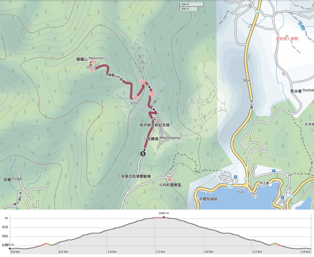
GPX file available here on Outdoor Active. (Account needed, but the free one works just fine.)
