
This has to be a new record for me, I rode this back in 2020, and it has languished in my drafts folder for literally years. Now it finally gets to see the light of day.
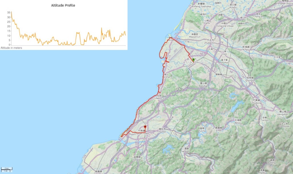
Distance: About 45km give or take.
Time: I spent about 6 hours on this route, but if you’re a fast cyclist then you could do it quicker.
Difficultly: 2/10 – Distance and wind are probably the only challenges you’ll face on this route. Signage is minimal, but as long as you’ve got an internet connection then you should be able to find your way.
Total ascent: Almost none, less than 50m.
Water: I drank about 1L over the course of the day, and had to detour to a 7-Eleven at one point to stock up on snacks.
Shade: Very little shade, if you are sensitive to the sun then make sure to take hands-free sun protection.
Mobile network: Clear throughout.
Enjoyment: This is good for stretching the legs and getting out, particularly if you like cycling but don’t like hills. Scenery wise, there are some pretty stretches and some not so pretty stretches. I enjoyed cycling through the tree lined areas and close to the farmland.
Jump to the bottom of this post for a map and GPX file.

Starting from the train station in Hsinchu’s East District, I picked up a YouBike and made my northwest, heading to join the coast by Nanliao, around the top end of the airport.

The journey through the city wasn’t particularly memorable, and I felt glad to finally see the start of the cycle path (and the end of the traffic).

Almost as soon as you leave the road, the trail cocoons you in a green tunnel of quietness, far more pleasant than the noisy roads.

The first 500m or so of bike trail takes you through Huanbao Sports Park (環保運動公園), then the trail takes a sharp right turn by a toilet block and I found myself on the coast.

A Love/Boat sculpture placed on the seawall for cyclists to pose with.

If the trail looks exposed and windy, that’s because it is! If you’re in search of somewhere to blow away the cobwebs then this would be a great choice.

Another piece of trailside artwork – I’m not sure what type of fish this.

In some places the cycle path runs slightly inland, sheltered from the worst of the wind by a high bank. (Although there’s still a footpath running along the top for people who appreicate the windswept look.)

The trail curves to the left after a while and I should have been able to take a bridge over Gangbei Irrigation Channel, but it was being fixed so instead I ended up following the channel inland for a way, crossing the next bridge up then doubling back again.

It’s remarkable just how quickly the city drops away to be replaced with more rural surroundings. Once I’d completed the detour and made it back to the coastal bikeway it was pretty easy to stick to the path.

At one point I found myself passing the southern end of the airport, several brooding jets visible in their bunkers.

The trail then heads back out towards the coast once more, and beside the trail there are tidal mudflats – I passed a group of kids being taken out to poke around in the low tide.

And a flock of African sacred ibis, they’re beautiful but an unwelcome non-native visitor here, where they outcompete many native species. (Numbers are down now though after a couple of years of population control.)

A break from the windy conditions came in the form of this tree-lined tunnel. I imagine this section is quite busy on weekends.

A little further along I cycled past the Crab Watching Trail by Xiangshan Wetlands (香山濕地). It looks very similar to the boardwalk at Gaomei Wetland, only not quite as long.

It was around here that the trail starts to draw close to some of the huge wind turbines that stand sentry all along the coast of Hsinchu.

The next point of interest was Haishan Fishing Port (海山漁港). The tide must have been way out when I passed through, the boats were all resting on the muddy bottom of the harbour.

Although I didn’t see any fishing boats in action, it’s clear that this area is an active fishing port. Nets and buoys were piled up in every available space.

Odd little sand dunes way out on the beach.

Another odd feature, this squat, lighthouse-esque structure looks like some of the follies I saw on walks back home.

A little way beyond the folly/shelter o found myself turning inland and away from the sea for a way. The trail joins the Western Coastal Expressway for a while…

…then takes a right turn back onto a more pleasant lane.

Here the cycle path runs through a wooded park not far from the water, but not quite within site of it.

At one point I found myself passing by some stables with a paddock – horses aren’t an animal I often see here.

There was one final stretch where the bikeway ran alongside the coast before dipping back inland again.

When the ocean view disappeared I found myself with views of farmland instead.
And even the odd war relic.

Longfeng Fishing Harbour (龍鳳漁港) was probably the busiest spot along the whole trail, and I imagine that there are refreshment stands open on weekends.

Then just beyond it was one of the quietest sections – one last tree lined run before I took a final turn inland.

Close to Zhunan Incineration Plant the bikeway turns left and I decided this would be a good natural end to the costal part of my journey and I could ride back towards Toufen Station.

At this point I just set Google Maps to direct me and followed as it led me through first farmland then semi-industrial areas and finally into the city.

How to get there
Google maps address: I picked up a bike outside Hsinchu Train Station and dropped it off close to Zhunan Station at the end. This was the longest I’d ever used one YouBike for and I got a message asking if I’d forgotten to return it, but as far as I can tell the fee was the same as usual.
Bike Rental: It’s possible to use YouBikes to cycle this route (as mentioned above), but if you only plan on going part way and then returning, then you might want to rent a bike from one of the many vendors close to the start of the bikeway.
GPS location:
- Start of the bikeway – N24 50.545 E120 55.410
- End of the bikeway – N24 40.475 E120 50.170
Public transport: This ride is easily accessible on the TRA train network.
Further reading: There are a few other resources out there if you want them, like this from Bike Hike Taipei, or for more of a challenge these guys have a 100km loop which takes in most of what I covered.
Hsinchu Coastal Bikeway Map
GPX file available here on Outdoor Active. (Account needed, but the free one works just fine.)
