
Sunrise on Kinmen
After seeing last night’s sunset from Kinmen’s highest peak, we decided to follow it up with watching the sunrise from the second-highest peak. There are three trails leading to the summit of Wuhu Hill, two of which can be joined together to make a short 30-minute loop, and with its northeast-facing lookout, it’s an ideal spot to watch the sun start its climb. A note on naming: You might see this peak called Zhaizai or Jhaizai Shan (寨子山), that’s because Wuhu (Five Tiger) Hill is actually a string of five conjoined peaks. From west to east, they are Huluo Hill, Mianqian Hill, Meiren Hill, Zhaizai Hill and Shi Hill. It looks like you can probably do a longish (maybe 9km) loop to connect them, but that wasn’t on the agenda for a pre-breakfast walk.
Distance: 0.8km – This could be extended in a couple of ways though.
Time: The walking took just under half an hour, but including time spent waiting for sunrise, this took us about 50 minutes.
Difficulty: 1.5/10 – A few steps, but it’s a very short and easy walk.
Total ascent: Around 50 metres.
Water: We took a thermos full of coffee to enjoy while we were waiting for the sun.
Shade: Not very much.
Mobile network: Clear throughout.
Enjoyment: Make sure you pick a clear morning without any haze if you hope to catch a clear sunrise.
Route type: Loop
Permit: None needed.
Jump to the bottom of this post for a trail map and GPX file.
After seeing last night’s sunset from Kinmen’s highest peak, we decided to follow it up with watching the sunrise from the second-highest peak. There are three trails leading to the summit of Wuhu Hill, two of which can be joined together to make a short 30-minute loop, and with its northeast-facing lookout, it’s an ideal spot to watch the sun start its climb.

The trail starts from the left side of Beiyue Temple. By the time we were ready to start climbing, the sky was already light, and sunrise was just twenty minutes away.

It’s steps more-or-less the whole way up, with a few short sections cut directly into the granite bedrock.

It took us a mere eight minutes to climb from the temple to the viewing platform, and our arrival at the top happened to coincide with what I think were probably the prettiest five minutes of the morning. The eastern sky was a fiery orange, and the moon was shrouded by cotton-candy-pink clouds.

Any regular readers of this blog will probably be aware that my partner is not one to pass up an opportunity for a nap. Naturally, this was no exception (but only once she’d figured out where to go for breakfast).

We had about a 15-minute wait before the sun came up. It was hard to tell where the horizon actually was because of the thick dawn haze (which is apparently common in this area). That same haze blunted the usual post-sunrise glow that you usually see.


But it wasn’t dimmed altogether. After waiting another ten minutes or so, a warm orange light spread out over the waters below us. To the north, the platform overlooks the village of Shanhou, where (according to the information board) the houses are built slightly lower as a form of protection against the brutal winds.

There are three trails that meet up at the summit here. If you’re interested in visiting Shanhou, you can walk down the more obvious trail in front of the viewing platform, but since we wanted to return to where we’d parked our scooter (and on to breakfast), we took the other trail leading down from behind the observation platform. The path is the one on the right here, but if you head straight for several metres, you can climb up to a second vantage point.

This one is on top of an old bunker and overlooks the twin wind turbines by Tianpu Reservoir.

The steps down are similar to the ones we’d taken on the way up, and the warm first light of the day made everything even prettier.

As you get nearer to the bottom of the trail, there are more old military installations, but unlike those we’d seen elsewhere, these had all been sealed up.


In just over five minutes, we’d made our way back down to the second trailhead and turned right onto the road. Once you walk up to the main road, you’ll see the Beiyue Temple a short way away on your right.


In the time it had taken us to complete our walk, the temple had been opened so I went in to have a look. In one side room, the walls were covered with kids’ depictions of Beiyue Temple, some complete with renderings of other Kinmen sights like hoopoes and wind lion gods.
How to get there
Google Maps address: The walk starts behind Beiyue Temple. There’s space to park scooters here, and spots for a couple of cars nearby too.
GPS location: N24 30.025 E118 26.030
Public transport: If you plan to come for sunrise, you’ll need to get yourself here. However, if you plan to come later on in the day, you can get the 25 bus from Shanwai to Shanhou and walk up via an alternative path.
More Kinmen Sights:
- Ci Lake Birdwatching Trail
- Kinmen Big Gorilla
- Kinmen Fort Walls
- Kinmen Wind Lion Gods
- Mount Taiwu
- Yongshi and Tiehan Forts
Wuhu Hill Trail Map
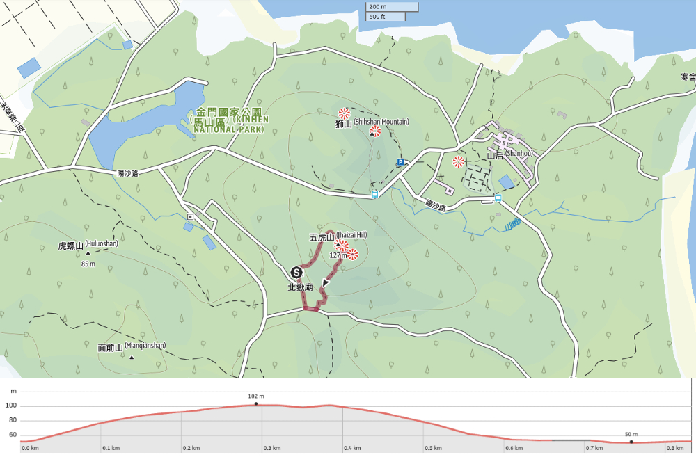
GPX file available here on Outdoor Active. (Account needed, but the free one works just fine.)
If you enjoy what I write and would like to help me pay for the cost of running this site or train tickets to the next trailhead, then feel free to throw a few dollars my way. You can find me on either PayPal or Buy Me a Coffee.
