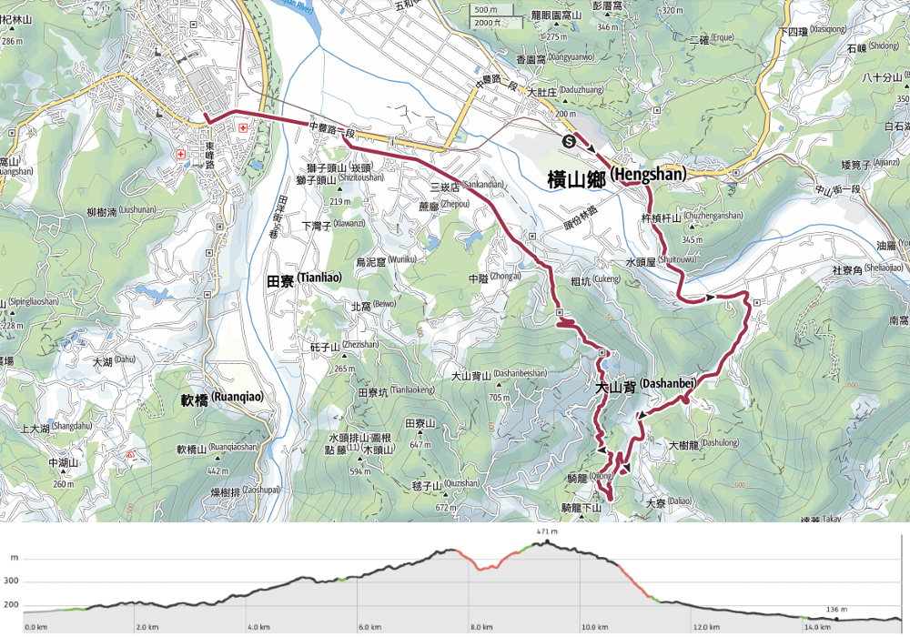
RSA20 – RSA25.1
I was by myself for this part of the journey. Teresa had accompanied me the day before, but needed to return to Taipei for work. The day was longish but easy, with a few short sections of historic trail breaking up longer sections of road. I revisited somewhere I hadn’t been for about six years and I could barely even remember it! Overall, it was a quiet day. Not my favourite part of the whole journey, but it had its merits.
RAKNUS SELU STAMPS:
- RSA21: Located at Dashan Beiyue (大山北月) – Closed on Mondays.
- RSA23: Located at Yokohama House (横山好室) – Check owner photos on Google Maps for monthly business hours.
DISTANCE: 15.8km – There are a couple of places you could shorten this part if you wanted to. I chose to keep this section longer so that I would have a shorter walk on the next section (and consequently more time to explore Beipu).
TIME: 5-6 hours. I spent about 5½ hours walking on this day. I wasn’t going particularly fast, but neither did I stop for very long at any one spot.
TOTAL ASCENT: A little under 400 metres.
DIFFICULTY (REGULAR TAIWAN HIKERS): 2/10 – This is very easy by pretty much any standard you want to just it by.
DIFFICULTY (NEW HIKERS): 3/10 – Only the length would make this a little tiring, otherwise it’s easy.
FOOD, DRINKS & PIT STOPS: There are convenience stores and restaurants at both the start and end. On weekends, the stalls around Leshan Temple will sell basic provisions, and the temple itself offers tea that you can fill your bottle with. I only took 0.5L and some snacks. This would have been fine on a weekend, but since the cafes along the way were closed when I went, it wasn’t quite enough.
TRAIL SURFACES: Mostly roads, some sections of paved trails.
SHADE: Long stretches of this walk are exposed. Bring sun protection on bright days.
MOBILE NETWORK: Mobile coverage was fair throughout.
SOLO HIKE-ABILITY: This trail is well-suited to walking solo.
SECTIONS COVERED:
- RSA20: Hsinchu District Road 35 → Dashan Beiyue Cafe → Qilong Historic Trail Entrance (竹35 →大山北月→騎龍古道口)
- RSA21: Qilong Historic Trail (騎龍古道)
- RSA22: Qilong Historic Trail → Leshan Hall → Chating Historic Trail Entrance (騎龍古道→樂善堂→茶亭古道口)
- RSA23: Chating Historic Trail (茶亭古道)
- RSA24: Chating Historic Trail → Hengshan Train Station (茶亭古道→橫山車站)
- RSA25.1: Hengshan Train Station → County Highway 122 → Hsinchu District Road 39 (橫山車站→縣道122→竹39)
Jump to the bottom of this post for a trail map, GPX file and all the other practicalities.
DETAILS & DIRECTIONS:

On Monday morning, I awoke to realise that the reason my feet had been frozen all night was that I’d been using the long side of the blanket widthways. Despite that, I’d managed to get almost nine hours sleep before my alarm woke me.


Breakfast was served from 8 in a little room halfway between the lodge’s rooms and the proprietor’s sanheyuan. I was the first one there, and the older gentleman running the establishment fussed over making sure I had enough. In place of meat and a boiled egg, I had stir-fried cabbage and a cube of preserved tofu to accompany my congee, peanuts, pickles and bun. It is a very Taiwan-style breakfast, and not one that I would necessarily pick for myself, but as it turned out, it was very suitable fuel for a day of walking.

As I was finishing my breakfast, I heard the train I’d been planning to take pulling out of the station, but I am intentionally not rushing this journey, so rather than stressing about it, I decided to wander around Neiwan a bit while I waited for the next one.


The first point of call was the suspension bridge at the top end of the village. Since the day was still so early, I was the sole visitor there watching the water tumble over the rocks far below. After that, I had a little time to stick my nose in the temple at the far end of the village before making my way over to the train station.

After a brief journey, the train pulled away, leaving me alone on the platform of Jiuzantou Station. No other passengers alighted here, and if there was anyone inside the station buildings, they stayed out of sight as I took the steps down from the platform, crossed the tracks and tapped my easy card on the exit gate.

From the station, turn right onto Provincial Highway 3 for a very brief stretch, then almost straight away take another right onto Xinxing Street to cut through the centre of the small settlement.

I found myself walking past lots of administrative buildings: the fire station, the police station, a post office, local government buildings, the kind of things which make for a functioning community. Further down the road, the needs being fulfilled were of the more immediate kind: a home goods stores stocked with everything, breakfast shops filling the air with the tempting smell of bacon, and temples providing spiritual assistance to all comers.


Speaking of temples, I managed to perfectly coincide my visit with the conclusion of (what I am assuming was) the town’s communal first day of work blessing ceremony. As I walked past the small alleyway leading to Jiuzantou Guo Wang Temple (九讚頭國王宮) a FLOOD of people came streaming out laden with baskets of fruit and yellow-fleshed whole cooked chickens transported in bright bundles of flower-patterned cloth.

Curiosity piqued, I headed against the glow of people to take a look. Rows of red trestle tables had been erected outside the temple doors and heavily made-up performers wandered amongst the crowd of worshippers who were busily gathering up their offerings. Opposite the temple was a stage that had obviously been decorated for the occasion, and to one side was a pretty little sanheyuan. I imagine whoever lives here in such an important part of the town must be the holder of much community gossip.


Returning to the main road, I followed the road almost as far as the railway line. Just before you cross it, the RST takes a right turn onto Ren’ai Street (aka Hsinchu District Road 35). You’ll stick with this road for quite some distance. At the next junction, merge left with another road leaving the town.

Looking back you can see the tall buildings of the cerement plant in the distance beyond the town and its farmland.

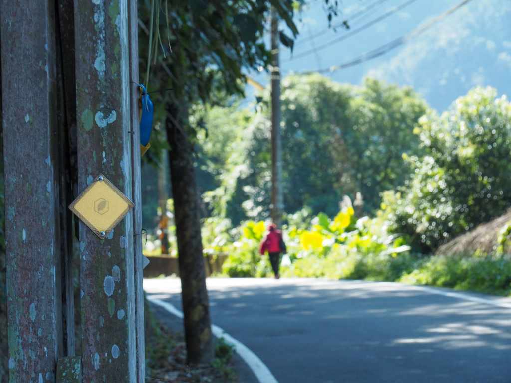
As with all of the sections I’ve walked so far, there are RST signs and tags at points all along the route.

The road took me through the tiny village of Shuitouwu. At the northern end of the street, a gaggle of grannies sat speaking Hakka in the shade of a pavilion, and further down the village a young mother had brought her infant child out to watch the smoke from an allotment fire catch and unfurl in the sunlight. The kid was encouraged to wave hello to me, but instead, he stood silently and sombrely watching me pass.

Moving on, the road dips down a little to cross Zhengchang Bridge (增昌大橋). The faded red structure has decorative tung flowers wrought into the metalwork of the railings and on tiles set into its single tower.

Youluo River (the same river I’d watched from Neiwan) flows beneath the span.

Someone was putting the railing to good use. I don’t know if it just happened to be that I timed this walk to coincide with peak drying season, or whether perhaps there are multiple harvests of this crop throughout the year, but I saw so many surfaces turned into impromptu vegetable-drying racks. Most of them were being used to dry fresh mustard greens like these, although in some places, the villagers were a step ahead in the process and the greens had already been pickled. (The latter is somewhat pungent.)
For a full run-down of the process, you can watch this video-although you should be warned, after seeing them get trampled by a barefoot grandpa, you may never want to eat them again.


At the far end of Zhengchang Bridge there is one road heading right and two heading left. Stick with Hsinchu District Road (the uppermost of the two left-hand routes and the one furthest from the water). If you’re unsure, look for the RST signage. The road soon falls in step with a small tributary of Youluo River and follows it through a village.

About half an hour after leaving the river behind, I saw the grand archway of Ciyuan Cihui Temple (慈願慈惠堂). Wondering if it had toilets and water, I decided to pay it a visit.


It transpired that while the temple had a toilet block, it was a little creepy and of uncertain plumbing status. I was similarly disappointed on the waterfront. However, the extra effort expended in reaching the temple was rewarded when I came face to face with a veritable army of larger-than-life gods. These fearsome visages, some of them over three metres in height are brought out on special occasions when they’re dinner by temple members to parade, dance and generally make merry.

Soon after rejoining the road, it veers to the left and falls in step with Daliao Stream. This waterway boasts an impressive variety of frog life. According to the folks who compiled the RST stamp passport, over a third of Taiwan’s frog species can be found just in this small creek. The fact that the water butts up against a road is a problem though, and it wasn’t long before I started to spot signs asking drivers to take care and look out for frogs. Luckily for them, local wildlife enthusiasts set up frog watch patrols during peak breeding season to try and escort the horny hoppers over the road safely.

Carparks and lots of signage alerted me to the fact that I was passing Fengxiang Falls (豐鄉瀑布). The waterfall is not a particularly scenic one–a concrete bridge squats just above it–but regardless, it has a pool and a pavilion which provided a nice spot to rest and shell some of the roast chestnuts I’d picked up in Neiwan the night before.

After a brief break, I carried on up the road and soon came to this map. It suggested that a small temple lay just a few steps away, so I opted to go and take a look.

The steps were in poor condition. Some had rotted through and others looked like they might not be around much longer. However, the distance was short, and after just a minute, I found myself in front of Fengxiang Xianbo Temple (豐鄉顯伯公). The diminutive stone temple is a beautiful one. It is set into its own semi-circular stone clearing, which is a little lower than the surrounding land. The temple itself is raised on a platform just higher than the outer edge of the clearing, and it almost has the feel of a campfire circle–somewhere you’re welcome to sit and share food.
The temple’s two different names on the map (Xianbo Temple) and the name carved into the stone (Fude Temple) made me curious. Fude temples are a very common type of temple seen widely throughout Taiwan. They are sometimes middling in size, but the vast majority are small wayside shrines, and the deity they house is invariably Tudi Gong, the land god, or sometimes Fude Zheng Shen. (Is this the same god or different? The verdict is out. I’ve seen contradictory answers to that question.) The fact that this temple was called Xianbo Temple and Fude Temple made me wonder if perhaps Xianbo temples are just another name for temples built to honour the god of the land. Well, it seems, yes, they are. The main difference between Xianbo temples and those called Fude or Tudi Gong temples is that the former tends to be found in regions with Hakka populations. Another slight difference is that while the land god temples built by Taiwanese-speaking communities tend to be positioned in a village, Hakka folk will erect small shrines wherever their work takes them–in the fields, beside washing pools, anywhere there are people with affairs to be overseen.


Follow the road onwards and upwards. There are a couple of roads branching off from District Road 35, but for the most part it’s easy to see where you’re going. I visited during a dry January, so the road was lined with many brightly blooming cherry trees.

As you climb, keep a look-out for this trail on the left. This is the start of Qilong Historic Trail. In a bit, I’d have to return here and continue my walk, but first I wanted to collect the next stamp in my passport. Keep on the road and follow it until you come across the carpark for Dashan Beiyue.


In late January, when I walked this section of trail, the trees surrounding the car park were full of vivid blossoms, but by mid-February (when I returned to collect the stamp), they were looking a bit tatty.

The stamp is set out in front of the restaurant in what was previously the playground of Fengxiang Elementary School (豐鄉國小). Several generations of local kids were educated here in the sixty years that the school was open (between 1923 and 1983), and photos of some of them can be seen displayed around the premises. The school then lay abandoned for three decades before being turned into the restaurant/boutique store it is today. Unfortunately, it was already too late for coffee, and we had decided to eat before leaving Sanwan (where we’d finished a different three-day stint along the trail), so we weren’t even a little hungry. But if I ever return, I’ve got my eye on some of the interesting-looking ice cream-based treats on offer.

After getting stamped, head back down the road to the start of Qilong Historic Trail. RST signage has been affixed to the information board detailing the various merits of the trail (multiple glutinous rice bridges, old family houses, steps that have been in use for over a century).


The start of Qilong Historic Trail is pleasant, but not especially historic feeling. Stone steps track down through cedar trees, and a white land god temple sits in a clearing above the path.

It wasn’t until I got a little further along that the historic quality of the trail started to reveal itself. There are several stretches where I found myself treading along old and worn (maybe original) stone steps. The steps are so narrow that it would be a real squeeze for two people to pass on them, and to make matters more complicated, they’ve been in use for so long that the earth to either side has worn away leaving deep channels ready to trip up any hiker not paying attention to where they’re treading.

The steps track down to a stream and the first of three glutinous rice bridges. For the uninitiated, the name comes from the fact that they were built using a mixture of glutinous rice paste, sugar and lime as an adhesive.

Cross the bridge and follow the steps up to a junction. Take the right path towards Leshan Temple (樂善堂).


The next little bit has the highest density of functions for this whole day’s walking, but as seems to be standard, it’s well-marked. At the first, take the middle route (the raised steps on the left side of the photo, there’s a third track on the left that’s hidden by the trees). Then at the next one, keep to the lower righthand path.

As the trail nears a dwelling, I found myself passing the second glutinous rice bridge.

Then after a brief climb up a track, I found myself being barked at by this nervous guardian of a small temple. Actually, it’s almost easy to miss this turning. I only spotted it because I saw the temple’s brick wall and went up to have a look. The RS turns left beyond the temple and climbs some steps.


For a brief spell, the trail is out in the open. Looking up, you can see fruit trees and forest, looking back, you can see distant hills.

But then soon enough you’re back under the shade of the bamboo.


Follow the path as far as will take you, then turn left onto the track, and left again onto a lane, heading upwards the whole while.

At the next junction, turn right following the sign towards Leshan Temple. From this point on you’ll be descending.

The area around Leshan Temple was busy and full of people even on a Monday. From other people’s descriptions online, you can expect to find vendors and crowds of you visit on the weekend.


The temple, which originally went by the name of Shixia Temple (石峽廟), was constructed in 1889, a few short years before Taiwan fell under Japanese rule. The building itself is exquisite-small and perfectly formed rather than grand and ostentatious. The walls are red brick built on a foot-high base of stone, and while inside it’s all terracotta floor tiles and stained wooden beams.
The central altar in the main hall enshrines the Three Buddhas (三寶佛) Sakyamuni, Amitaba, and Bhaisajyaguru. On the left altar, you’ll find another triumvirate-the Three Officials of Earth Heaven and Water that have been popping up in temples we’ve passed all along this trail. Along with them are Lord Wenchang (文昌帝君, friend to all students with upcoming exams) and the female deity Zhusheng Niangniang (注生娘娘, I’ve also seen her called 順天聖母). The latter is an interesting figure. Legends relating to her origins suggest that she was once a village’s wise woman, and when villagers came to her to save them from the effects of a drought, she induced her own abortion so as to be able to perform the required ritual. The ritual went off without a hitch, but she had over-expended herself in the process and ended up passing away. Before she died though, the wise woman made a vow to become the protector of pregnancies and childbirth.
On the temple’s righthand altar you’ll find Yimin Ye, the spiritual embodiment of the sacrifice of Hakka folk. Yimin worship is a unique feature of the cultural landscape for the Hakka folk who settled in Taiwan. Broadly speaking, it refers to worshipping those who died defending their settlements during historic struggles. What’s the difference between worshipping Yimin and Yimin Ye? Not much…(I think). The “Ye” part of the name refers to a specific figure, although it seems to be a specific figure used in a general sense, not actually any one character from history.

Beside the original temple, there is a second more modern building topped with a giant statue of Guanyin. A bench outside holds a cylindrical tea urn filled with hot ginger tea. I filled up my bottle and walked to take a look at the view.


From the platform in front of the temple, you can see west all the way over Zhudong and Zhubei to the coast. And looking inland, I could just spot the supports of Zhengchang Bridge peaking up from behind some trees.

Steps beside the viewing platform lead down to rejoin the road, and soon I was on my way again. From the temple, continue to follow the road downhill until you arrive at this bend in the road.


The RST continues down steps beyond these neighbouring structures. This is the start of Chating Historic Trail (茶亭古道), and anyone who can read the Chinese characters of the name will surely spot the reason for it being called this. I’m not sure if “Tea Pavilion” is a good translation for “茶亭”, but it seems close enough for the purposes of understanding. The building closest to the trail has a raised platform on which you’ll find a table surrounded by several boulders serving as seats and is very obviously meant to be a resting place for travellers. Although the pavilion and its neighbouring temple have obviously been remodelled, versions of them have stood here for decades. Passing travellers would pray at the temple for safe passage, then take shelter at the pavilion to rest and refresh before continuing their journeys.

Much like the pavilion, most of Chating Historic Trail had been replaced with modern building materials, but there’s still one short section where the original footworn steps can be seen.

I passed the day’s third and final glutinous rice bridge close to the end of the trail. After that, the path joins a track and the RST veers left.

A pack of three guard dogs rushed at me when I joined the road, but they seemed more intent on being loud than actually hindering my progress. Beyond the house, turn left onto the road.


At the next junction, head straight as you merge with Section 2, Hengshan Street and stick with that for the next little while. I grabbed a can of cold coffee from the convenience store on the corner to give myself a bit of a kick.

The road is lined by farmland, houses and the odd temple. I passed an old woman out for a walk with a foreign helper who asked me cheerily where I was going. In fact, it seemed like all the residents of the street were interested in practising their English with me because a little further along, I met a pair of kids, one was probably 8, the other 11 or 12. They had got a couple of metres past me, when all of a sudden one of them mustered up the courage to mutter a sneaky “fak-a-yooo”.

Hengshan Station is just another couple of minutes away if you turn right down the aptly named Zhanqian Road 站前路). And perhaps more importantly, this is where you will find the trail passport stamp for RSA 23.

The stamp is located within—or more accurately, just outside— Yokohama House (橫山好室), an old rice mill that has been converted into a coffee shop and hub for community activities.


The stamp shows the tea pavilion that I’d passed earlier with a couple of dapper-looking tea drinkers sat around and enjoying the shade. Inside the store, you can see lots of old photos of the region, and some of the old mill equipment has been left in situ.
Initially, it had been my plan to stop here and get a train back. However, it was still relatively early, and my legs had extra energy, so I decided to push on for a bit more.


When you reach the end of the road, turn right, then after another 200m, take a left onto Provincial Highway No.3 right by the 7-Eleven. I stopped here to refuel and cool off before carrying on for the last little way.

Keep heading west on the highway as it crosses Shangping River on Zhudong Bridge. (No, there is no pavement. Yes, pedestrians are allowed to walk over it. No, it doesn’t feel particularly safe to do so.)

If you can, make sure to cross on the side that has you walking against the flow of the traffic. You can spot Five Finger mounting jutting up beyond the surrounding peaks.


The RST sticks with Provincial Highway No. 3 as it cups the southwest edge of Zhudong. Stay with it until you spot a petrol station opposite a 7-Eleven, then turn right onto Zhongzheng South Road (unless you want to carry on walking, in which case you’ll need to stick with the highway a bit further).

The bus stop is an easily missed spot on the side of the road, and had it not been for the other person waiting there, I might have thought I was in the wrong place. Luckily I wasn’t though, and within fifteen minutes, I was seated on a bus bound for Taipei.
GETTING THERE
Public transport:
- Getting to Jiuzantou Station by train – You’ll likely need to make three transfers if you’re coming by train (at least, you will if you’re starting in Taipei). Catch any train that will get you to Hsinchu (local trains and tze-chiang trains do not need special tickets (you can just swipe in with your EasyCard), but if you take the faster puyuma train, you’ll need to buy a ticket from the station or on the app (Apple version here and Android here). Then you’ll need to swap onto a local train to Zhudong, then at Zhudong you’ll have to change again onto the Neiwan Line and then ride it all the way to Jiuzantou Station.
- Getting to Jiuzantou Station by bus – Take the 1820 or 1820A from Taipei Bus Station (from the fourth floor). Alight at Taiwan Cement bus stop and wait there for the next Fastline 6 or Fastline 6A bus. Ride it as far as Dadu bus stop, then alight and walk the remaining couple of minutes to the start of the walk.
- Returning from Hengshan – Take the 1820 or 1820A from Xiagongguan to Taipei bus station. Buses go roughly every 20 minutes during peak times and pass MRT stations.
Accommodation:
Staying in Hengshan – There isn’t a huge amount of options in this area. If you want to camp, there are some basic campsites in the area (managed, not wild), but if you want a proper bed, it’s probably best to head up to Neiwan. I stayed in a little B&B in Neiwan the evening before walking this and caught the train back to the start of the trail:
- Name in Chinese: 山舍民宿
- Address: 312新竹縣橫山鄉內灣村內灣92號
- Contact: 035849988
- Cost: $1300 for a two-person room
RAKNUS SELU DAY 4 TRAIL MAP
GPX file available here on Outdoor Active. (Account needed, but the free one works just fine.)
If you enjoy what I write and would like to help me pay for the cost of running this site or train tickets to the next trailhead, then feel free to throw a few dollars my way. You can find me on PayPal, Buy Me a Coffee or Ko-fi, (and if you’re curious about the difference between the three you can check my about page).
