
RSA02 – RSA11.2
Looking back at the photos to try and compile this route guide, the huge variety of scenes makes it feels like this was a really long walk but in reality, it’s not all that far. This is the first day on the Raknus Selu Trail which sees you getting off the roads and walking on some of the old trails that crisscross the area’s hills. Overall, it’s quite a gentle day, but still enough of a trek that food is both exceedingly welcome and ten times as tasty by the time you find yourself arriving in Guanxi.
RAKNUS SELU STAMPS: There are two passport stamps that can be collected on this day’s walking.
- RSA06: Located at Taoyuan Shiyifen Fine Art Museum (桃園十一份美術館)
- RSA08 – Located at Cukeng Kiln Art Studio (粗坑窯藝術空間)
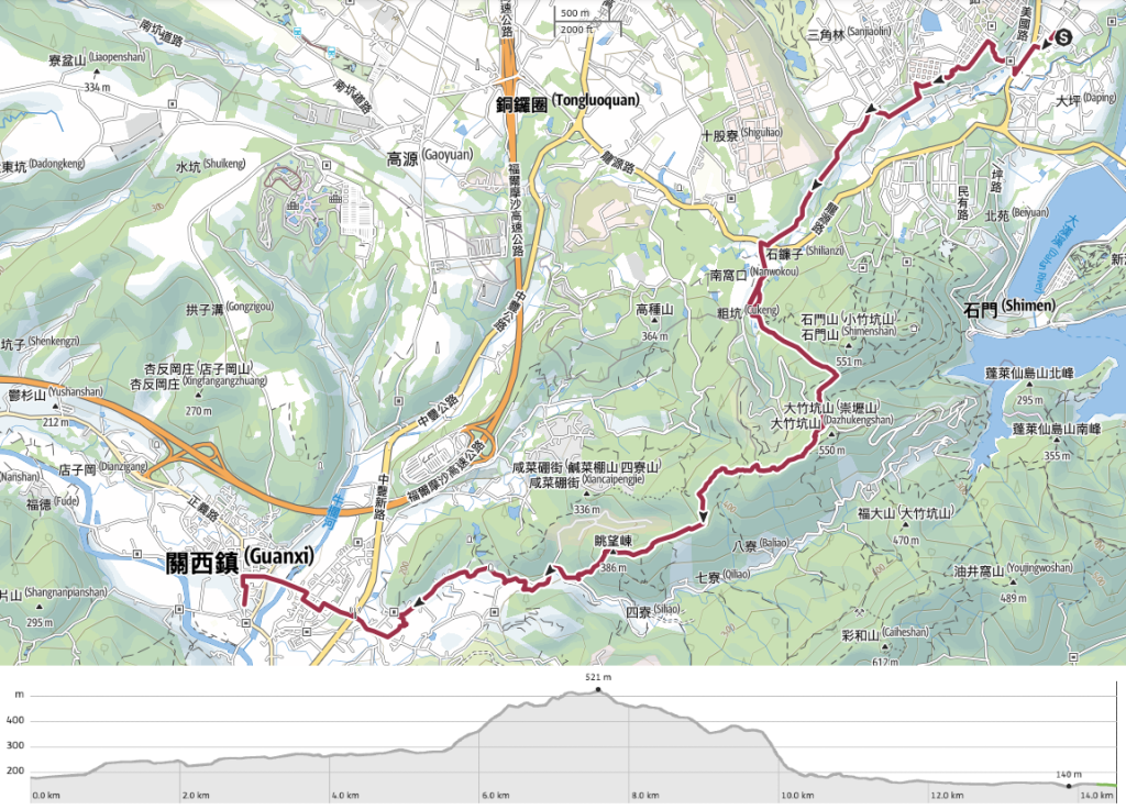
DISTANCE: About 15.5km, plus a little extra wandering around Guanxi after we arrived.
TIME: Almost 6½ hours at a very casual pace.
TOTAL ASCENT: A little over 350 metres.
DIFFICULTY (REGULAR TAIWAN HIKERS): 3-4/10 – On a dry day this is pretty easy, if a little long. When we went, the signage was clear, and if it remains that way then it’s very easy to navigate.
DIFFICULTY (NEW HIKERS): 5/6 – Steep ascents and descents. You wouldn’t want to do this on a wet day. Some sections might feel a bit ‘wild’ if you’re unfamiliar with walking historic trails in Taiwan.
FOOD, DRINKS & PIT STOPS: There are convenience stores and restaurants at both ends of this hike, but aside from the cafe at Cukeng Kiln Art Studio (where one of the stamps is kept), there’s little in between so make sure to prepare accordingly. We carried about 1L each and some snacks.
TRAIL SURFACES: Some roads and some unpaved tracks with very little in between. Some sections are aided by ropes.
SHADE: Patchy shade. On a bright day, I would have wanted a sun hat and long sleeves.
MOBILE NETWORK: A couple of spots had weak signal, but mostly ok.
SOLO HIKE-ABILITY: This section is generally easy and safe to walk alone, but only if you’re already familiar with Taiwan’s trails.
TAIWAN 100 MINOR PEAKS: With just a short diversion, you can include a trip to Mount Shimen (No. 24) as part of this route.
OTHER: You might want gloves and/or a hiking stick to aid with the steep portions of this trail. Also, softer-soled shoes are advisable given the amount of walking on roads that you’ll be doing.
SECTIONS COVERED: Click on the links to jump to that section of the post.
- RSA02: Linpi Historic Trail (林埤古道)
- RSA03: Linpi Historic Trail Trailhead → Jia-an East Road → Aiguo Road → Huofangqi Historic Trail Trailhead (林埤古道口→佳安東路→愛國路→伙房崎古道口)
- RSA04: Huofangqi Historic Trail (伙房崎古道)
- RSA05: Huofangqi Historic Trail Trailhead → Qingshuikeng Road → Daniuqi Historic Trail Trailhead (伙房崎古道→清水坑路→打牛崎古道口)
- RSA06: Daniuqi Historic Trail (打牛崎古道)
- RSA07: Daniuqi Historic Trail Trailhead → Minsu Road → Taoyuan District Road 65 → Xiaocukeng Historic Trail Trailhead (打牛崎古道口→民宿路→桃65→小粗坑古道口)
- RSA08.1: Xioacukeng Historic Trail (小粗坑古道)
- RSA08.2: Xioacukeng Historic Trail – Industrial Road (小粗坑古道–產業路道)
- RSA09: Xioacukeng Historic Trail → Hsinchu District Road 28 → Mount Shiliao Trailhead (小粗坑古道→竹28→十寮山登山口)
- RSA10: Mount Shiliao Trailhead → Mount Shiliao → Mount Laohu → Daniuqi Historic Trail (十寮山登山口→十寮山→老虎山→打牛崎古道)
- RSA11.1: Daniuqi Historic Trail Trailhead → Hsinchu District Road 28 → Provincial Highway No. 3 ( 打牛崎古道→竹28→台3線)
- RSA11.2: Provincial Highway No. 3 → Dongan Old Street → Guanxi Town Centre (台3線→東安古橋→關西市區)
Jump to the bottom of this post for a trail map, GPX file and all the other practicalities.
DETAILS & DIRECTIONS:

The night before, we’d gone over our travel plans with our host, Mr Zhong, and he thought we’d be able to arrive in Guanxi on time to meet our next hosts if we left by 8:30. So we woke at about 7:40, got dressed, packed a few things and went down for breakfast. Mr. Zhong personally cooks each guest a fried egg and a thick slice of toast, and as we ate, he took the time to chat with us about a few interesting points along the route we would be taking.
After finishing our breakfast, we returned to the room to sort out a few final things and pick up our packs. By the time we made it back downstairs, Mr Zhong had prepared both of us little bags filled with crackers and chocolate-coated nuts. “There aren’t really any places to get snacks once you’ve left here, and it’s cold, so you’ll need extra energy.” I was touched by his thoughtfulness. There are places which charge ten times the price without providing this type of genuine warmth.
Before we left, he asked if he could take a selfie with us as part of a kind of ritual that he has to welcome and say goodbye to all of his guests.

09:12 – Returning back to where we stopped our journey the night before, we headed down the main thoroughfare of Zhongzheng Road until meeting the entrance to Meiguo Road (美國路, or maybe America Road). In Taiwan, something like 98% of the roads are either Zhongzheng Road, Zhongshan Road or Zhonghua (OK, so I might be exaggerating… a little, but they really are common), so to see somewhere named after America quite odd. As is often the case with such aberrations, this unusual name has very specific roots.
In the 1950s, the KMT government was in the process of building a nation, and that included lots of infrastructure projects like the huge Shimen Reservoir. The government borrowed both money and expertise from the US, bringing in large numbers of engineers to work on the project. Some sources claim that there were so many Americans working on the reservoir that there was basically one American engineer for every Taiwanese engineer. The village at the top end of Meiguo Road was built to accommodate the engineers and their families (except at that time, it wasn’t Meiguo Road, it was Xinsheng Road). It’s quite a lovely little set-up, with several rows of single-story houses arranged around a large central lawn – built to be a small and perfectly formed community. Locals passing by on Xinsheng Road would often see the American kids playing out on the grass, and over time, they started to refer to the pass as Meiguo Road.
The engineers eventually finished what they’d come to do. They packed up and returned to their home country, leaving behind them some impressive irrigation infrastructure, a nice village, and Meiguo Road. The name stuck. On the maps it was still Xinsheng Road, but no one who lived there called it that. That changed after local authorities decided to update maps and signage (I think in 2018) to more accurately represent the ways locals referred to their own hometowns. Now Meiguo Road is the official name – bringing a little roadside history lesson to all of those curious enough to ask.

09:14 – We didn’t stay on Meiguo Road for long though. The RST takes a sharp left turn up some steps. On the map, this is marked as the starting point of RSA02 (Linpi Historic Trail/林埤古道).


09:15 – The trail crosses over Qingshuikeng Street then crosses a bridge over the interesting dual channels of Shimen Big Canal (石門大圳). This waterway was built around the same time as Shimen Reservoir, and according to Tony Huang’s informative writing on the subject, the Shimen Big Canal is one of two large canals in the area, and winds through the countryside for 27.4km. Spilling out from its steady flow there are 18 smaller branch canals and 43 even smaller irrigation channels, getting water where it needs to go – into the farmers’ fields.
Almost every article you can read online about the subject says that you should really visit on a clear day during the cherry blossom season so that you can enjoy the pale blues and pinks reflected on the water’s glassy surface.

Linpi Historic Trail continues up the steps and through a little more greenery (although there are signs of construction beside the trail, so I’m not sure if it will remain green indefinitely).


09:21 – At the top of the steps, follow the path towards the greenery, then take a left turn onto Jiancheng Road. Here you’ll find the expansive grassy lawn that once sat at the heart of Longtan’s little America (it’s now managed by the Water Resources Protection Bureau). Despite the coldness of the weather, there were plenty of people out and walking around when we visited. Follow the road as it takes you between the two facing structures of Jhong Jhang Hall and Jhong Shan Hall (中正堂 and 中山堂 – Wade-Giles romanisation going strong out here in the countryside). The RST takes a left turn here onto Jia’an East Road, but if you’re collecting the stamps in your Raknus Selu Trail Passport, then you’ll need to head straight and go in search of the next one.

09:26 – I left Teresa sunning herself on a bench by the lawn, and headed more-or-less straight until I arrived at Shiyifen Art Gallery. Google maps told me it should open at 9am (although it looks like that’s now been updated to 10am), but I asked a member of staff about the stamp and he told me to let myself into the foyer. (When I visited, the stamp was being kept in the room just on the right at the top of the steps.)


There were a couple of extra passports on the desk, so I asked Teresa if she wanted one to stamp for herself (which of course she did). This stamp is paired with RSA04 (despite being located just off of RSA02 and RSA03) and depicts a brick-built woodburning stove with a pot of something hot and steamy on the go.

Stamp suitably stamped, I retraced my steps back through the village towards where I’d left Teresa. The low, single-storey houses (what we’d call bungalows back where I’m from) had the uncanny effect of making me feel like either time or place had shifted somehow off-kilter, particularly with everyone bundled up warm against the bite of the cold air.

09:36 – When I returned to Jia’an East Road, Teresa was nowhere in sight, so I turned onto it and kept walking, all the time assuming she had started making her way slowly in the direction I’d told her we would be heating. This is the start of RSA03 (which stretches from the top trailhead of Linpi Trail along Aiguo Road and ends at the top of Huofangqi Historic Trail).


09:40 – By the time I reached the junction, I still hadn’t caught up with Teresa, so I called her to find out where she’d got to. Unsurprisingly, she had made friends with some dogs and was still in the area where I’d left her, so I waited about ten minutes for her to catch up. At the top end of Jia’an East Road, turn left then walk straight over a roundabout (or do you go straight around a roundabout?).

09:57 – Shortly after the roundabout, there’s a junction where you need to take the left fork. Be careful of fast-moving cars along this stretch. Then after another few minutes, you’ll find yourself at the start of Huofangqi Historic Trail (伙房崎古道).
(Actually, if you’re feeling lazy, you can just skip this section and continue along the road until you reconnect with the RST at the end of RSA06, right about here.)


10:01 – Turn left off the road and into the narrow trail cutting between the forest and a chicken farm. In fact, as Chinese readers could maybe guess, Huofangqi Historic Trail leads right past the farm’s kitchen (“伙房” means “kitchen”). Steps lead down through mixed bamboo forests for a few minutes before rejoining Qingshuikeng Road. Turn right onto the road. This is the start of RSA05.

10:07 – 10:07 – Qingshuikeng Street leads through farmland and past a natural spring. We only realised the latter when we saw a group of maybe six or seven people standing around a few parked scooters and cars, each taking turns to fill huge water bottles from the spout. Perhaps this is even the source of the road’s name. This was something I found unusual when I first moved to Taiwan, but it’s actually pretty common, even on the outskirts of Taipei, I guess some people are just very willing to use a lot of time and energy to get something for free. Just as the way starts to claim again, look out for some RS signage on your right and head back into the treeline. This is the start of RSA06 (Daniuqi Historic Trail/打牛崎古道). This trail’s name means “Beating the Ox,” and rather than that being some type of strange euphemism, it really was a very literal name. It covers quite a steep climb, and old-time farmers who had cattle to help transport their goods would have to hit them to get them to keep pulling their heavy burdens onwards and upwards.


10:09 – Daniuqi Historic Trail is shorter than Huofanqi Historic Trail so it took us just two minutes to meet the track at the top. We were greeted by a friendly black dog (which of course, Teresa had an extended conversation with), then followed the track to the lane. Turn right onto the lane and head uphill. In a minute or two, we found ourselves back where we would have been if we had just headed straight on Aiguo Road. At the next junction, take a left turn onto Minsu Road.

When you turn onto Minsu Road, you’ll find yourself starting RSA07. This section is all road walking and will take you right up to the start of Xiaocukeng Historic Trail. This was the first part of the day’s walking where we were able to enjoy the scenery. There were farms on both sides, and multi-layered hills stretched up to meet the clouds behind neat rows of tea. At some point, Minsu Road merges with Taoyuan District Road 65, but you just need to keep heading mostly straight.


10:33 – Follow Taoyuan District Road 65, all the way until it joins Provincial Highway 3C. Cross over and head right for about 50 metres until you meet Cukeng Road, then turn left onto it. Somehow we managed to get ourselves a little turned around at this point and walked the wrong way for about 200m before figuring out our mistake.

10:43 – The RST takes a left turn off of Cukeng Road and follows an even smaller lane. But wait! If you’re collecting stamps, you’ll have to first take the road on the right and follow it for about 150m until you reach Cukeng Kiln Art Studio. We thought you could reach it from the lower entrance, but found out the hard way that you can’t. So once again, I left Teresa to sit and wait while I went and figured out where the stamp was kept.


The entrance to the studio is impossible to miss thanks to the imposing sculptures that flank the brick gateway. When I walked in, there wasn’t anyone in the front room, so I walked through to the valley-facing room and found a group of people working with clay. I asked if anyone knew anything about the stamps, and someone was dispatched to help me. The stamp is kept in the tea garden which is down a flight of stairs to the right just inside the main entrance. When we walked down, there was a woman practising on her erhu and chickens pecking for bugs in the grass. It looks like a really relaxing place to stop a while and enjoy a drink (they do sell drinks, but I couldn’t see where or who was serving).
This stamp is paired with RSA08, and depicts a clutch of ramie leaves. If you don’t know what ramie leaves are, you’re not alone, I didn’t know either. But turns out that it’s a very useful plant. It is widespread throughout eastern Asia and the plant’s large, almost heart-shaped leaves have long been used both in cooking and as a raw material for making textiles. In Hakka cultures specifically, it is used as an ingredient in ramie dumplings. This is a quite labor-intensive procedure which involves picking the leaves, drying them, then boiling the dried leaves in water, straining the leaf mush out and adding it to the flour to make the dumpling skin… and that’s before you even get started on preparing the filling, shaping the dumplings or steaming them!

I retraced my steps back to the previous junction and took the lane leading along the water. When I arrived back at the spot where I’d left her, I found Teresa once again enjoying her break. She said someone had driven past and stopped to ask if she would like a lift to Guanxi. The driver told her it was just fifteen minutes away and that it would be no trouble for him to take her. This is the difference between walkers and non-walkers I guess. Perhaps our goal of walking from one town to another seems utterly incomprehensible to them when there are easier options.

11:03 – Keep following the road until you meet this small earth god shrine beside a chicken farm and a bridge. Turn left and walk over the bridge towards the tree line. This is the start of RSA08.1 (Xiaocukeng Historic Trail/小粗坑古道). I actually have an ancient post on this site detailing an earlier visit to this trail and the nearby Shimen Shan (one of the Xiao Bai Yue). It was written in 2017, just a few months after I arrived in Taiwan, and I dare not read it for fear that I will cringe at my former self.


This was the first time on the RST that I felt the trail got properly away from roads and civilisation. The path tracks steeply upwards beside a stream, and at times, the path almost becomes the stream (although I think this is probably due to the almost constant rain northern Taiwan had been enduring just prior to our walk). There’s one junction where a path leading up to Shimen Shan branches off on the left, but ignore it and keep looking for the RST signage.

11:33 – About two-thirds of the way up, we stopped for a short snack break in a clearing with some benches. Right next to a clearing, there was a hole where the stream emerged after having travelled underground for a short distance, and in the sky above us we watched a bird of prey flying in broad, lazy circles.


11:55 – After another steep 10-minute climb, we arrived at a junction. Turn right onto the farming track and follow it all the way to the end. This very brief (just 6 minutes) section is RSA08.2)


12:04 – Take a left turn onto Cukeng Road (the same one you were on earlier), and follow the road uphill for another 5-7b minutes until you reach the bend in the second photo. The RST heads straight into the trees at the apex of this bend (just to the left of where the car is parked). It has some fairly prominent yellow signage though, so it should be easy to spot. This short section of road is RSA09, and once you leave the road again, you’ve arrived at the start of RSA10.

There are quite a few side trails to pay attention to along this next section, but in every single case, there is well-placed RST signage. Each time you come to a junction, look a little further down each of the possible routes, and one will have a visible trail marker. It’s really very impressive how thoroughly planned out this route has been. I hope it gets enough walkers and attention to ensure it’s longevity. These trails need people to walk them, otherwise they start to fade very quickly.


12:23 – After a short climb, we arrived at the first named peak of our journey – Shiliao Shan. The summit sits at 538 metres above sea level, and has a partial view through trees on its northwestern edge. Our attention was drawn to the sturdy triangulation marker in the middle of the clearing, the characters engraved on it (“內務局”) refer to an administrative department of the Japanese government, meaning it has obviously been here quite a long time. A clue to precisely how long it has been there can be seen on another side of the marker where you can find characters that read “昭和四年”. I think this refers to the fourth year of the Showa era, which would mean the marker was placed here almost a century ago, in 1929.

Starting from this point, the trail becomes a series of short descents interspersed with climbs of a similar length and intensity. If I’d known just how much rope grabbing was going to be involved, I would have taken the time to dig my gloves out of the pack because the wet ropes in the cold December air felt practically icy to the touch.


12:34 – Not far after this first descent, the path veers left just as it hits an area of private land. Shortly after that, there’s a four-way junction (photo on the right). The RST heads straight over here and starts to climb again.

Just as the trail started to dip again, we spotted this tree bearing scars which mark it out as being a rhino-beetle hangout. These giant bugs emerge in late spring and chew centimetre-wide grooves in their host trees in between battles determining who gets to procreate.


12:46 – Another climb, another summit. At the top of this slope, we found ourselves on Dongbenjiwo Shan (東畚箕窩山). There is little of note to say about this peak, it’s just a small clearing without any kind of view.

The walking along this section is rather pleasant. The trail is clear and wide enough for one person to walk comfortably without brushing against the plants. We passed one other couple going in the opposite direction, but I’d guess this gets a reasonable amount of traffic given how well-defined it is. Most of the time it’s all mixed forest, but we found ourselves weaving amongst stalks of bamboo in a couple of places.

13:09 – The next noteworthy we passed was Shiren Peak (石人崠). It seems that several hills along the way have been recently given new signage. They’re the same colour as the other RST signs, so I guess they were probably all installed at the same time.
I had never before seen the character “崠” used to mean “mountain” or “peak”, so I asked a local friend (Anusha, the woman who’s behind Taiwan Hikes), and she informed me that it’s a Hakka word for peak.
All of a sudden, the trail breaks out of the tree cover and you have a clear view of the hills stretching south over Hsinchu and over to Miaoli. Among those we could see were Jialuo Shan (far left), Niaozui Shan (somewhere in the middle), and Dashanbei Shan (on the right).

13:21 – The next junction didn’t appear on my map, but it was clearly signposted. Head straight over here following signs towards Laohu Shan. It was around here that we passed a couple of concrete posts indicating the boundary of a military campsite. Judging by how weathered they looked, I assumed they were maybe obsolete, but a closer look at the map reveals a military site in the valley to the right side of the trail, so it seems my initial assumption was wrong.


13:31 – The penultimate peak of the day was Laohu Shan (老虎山, or Tiger Mountain). We met a family with two kids here, all bundled up against the cold and being forced to have their photo taken posing like a tiger next to the peak marker. (I think they would have been happy to, just not with us there as an audience.) We paused for a quick snack here, then continued on. In addition to the one we arrived on, are two trails leading away from this peak. Take the trail which cuts straight over the clearing and down the far side (signposted as going in the direction of 打牛崎登山口), not the one which veers left.
I think this might be the first walk I’ve done which includes two separate historic trails with the same name. (One of the short trails up a hill right at the start of the day’s walking was also called Daniuqi Historic Trail.)

13:42 – We passed one final summit, Taowang Peak (眺望崠) before starting the descent to the road. This hill was evidently named for its good view, but I guess the trees have done some growing because there’s nothing to be seen now.

13:48 – It’s hard to see from this photo, but there’s a junction here. Take the path heading straight and down. (The other trail is hidden in the bushes to the left of the frame.)

This next section is the single steepest descent of the whole day’s walking. I was quite happy not to be doing it in the opposite direction. The top part of the descent is all dirt path, but when you hit the stone (and then concrete) steps, you’ll know you’re approaching the road.


14:12 – At the trailhead, turn right onto Hsinchu District Road 28 and then follow it as it hugs Siliao Stream (四寮溪) downhill past a large Buddhist Temple and its carpark. From here, you’ve started following RSA11.1. At the furthest end of the carpark, look out for this butterfly sign and a map. This marks the start of Siliao Stream Historic Trail. This section is a slight diversion from the RST maps that I’ve seen, but you should definitely take it. The official route is all road walking, whereas this one takes you along the stream.

14:19 – Turn left onto the wooden steps and walk down to meet the water. (The steps were a little suspect and definitely in need of repair, so my guess is that this will become part of the official route, just not yet.)

The path leads to a wooden platform and steps lead down from that to the water’s edge. From here, the route diverts along a narrow waffle brick pathway right beside the water.


When I say “right beside,” I really do mean “right beside.” In a couple of places, the water was on both sides of the pathway, and after a couple of hundred metres we found ourselves crossing over to the far side.
14:26 – To get across, you have to walk over these concrete stepping stones. Due to the recent heavy rains, some of the stones were partly submerged, which made them slightly slippery, and others were blocked up with a whole load of debris.

After crossing, the trail continues to follow the water. Then once we’d passed this bridge, the trail started to climb. Knowing that we would have to come back to the same level as the stream in just a couple of hundred metres, I wasn’t exactly thrilled to be climbing.


Thankfully for our tired legs though, the climb was short, and soon enough, we were descending again. Once you hit the water, turn left and follow the covered side channel as far as it’ll take you. Parts of this section were a little boggy and/or flooded.

When that odd concrete structure emerged out of the greenery, my first thought was that it was some type of weird architectural flourish that has been abandoned, but a closer look revealed it to be nothing more exciting than a couple of preformed concrete culvert sections that had been stacked on top of each other. Turn right over the bridge just before you reach the road.


14:43 – Steps on the far side of the bridge lead up to a road junction with a tree traffic island. If you walk to the tree, you’ll see a land god temple further down the road to your left – head towards it. At this point, we rejoined the official RST that we were using as our guide.

Further proof that we were back on the right track came in the form of this easily-missed sign beside some ponds.


14:59 – The scenery on left was very pastoral. Lots of small farms, produce drying in courtyards, woodpiles and welly boots close to each front door. At the junction in the second photo, take a left turn into what feels like a private driveway. (If you find yourself walking past Kunlun Qixing Temple you’ve gone too far.)

Even as we walked all the way in front of the house, it felt like we were heading towards a dead-end, but suddenly this raised track through the middle of the farmland revealed itself.


15:06 – The track takes a 90-degree right turn and heads towards this blue barn before taking a left turn to walk alongside it. We passed a couple of noisy dogs hanging out in front of their houses here, but none of them was interested in doing anything more scary than barking. Keep walking straight until you rejoin the wider Zhongshan East Road, then turn right and stay on the same trajectory right into the centre of Guanxi.

I wouldn’t have known it if I hadn’t looked at the map, but this waterway is the very same Siliao Stream that we were following earlier in the journey.


15:15 – Follow Zhongshan East Road to the intersection with Provincial Highway No. 3, then cross straight over. A statue depicting a farming family at work at the entrance to Mingfeng Park lets you know that you’ve arrived in Guanxi Town.

15:23 – To reach the historic centre of Guanxi, you have to cross Niulan River via the impressive Dong’an Old Bridge (東安古橋).

Admittedly, from the road there’s not much impressive about it, but if you take a little jaunt to look at it from the path which runs next to the river, you’ll see what I mean.

The original bridge was built in 1933 by the Japanese authorities and has stood the test of time well. But in 2003, a second structure was built right next to it in order to accommodate the increased flow of traffic to the town.

From the bridge you can look downstream over the river’s wide course and see some of the hills that feature in the next chapter of this journey.


We found ourselves walking past more and more stores and soon arrived on a market street with a few vendors still peddling their wares. Once you reach the FamilyMart, take a left turn onto Zhengyi Road.

Zhengyi Road only runs for another hundred metres or so before you have to turn left onto Datong Road, then almost immediately take another right onto Zhongzheng Road. This is the top end of Guanxi Old Street.

Among the red brick and decorative tilework on the old street, one of the buildings that stood out was the shuttered frontage of the old Guanxi Police Station (關西分駐所). The neighbouring Commander’s dormitory (on Datong Road) has been renovated and turned into something of an attraction, but this one remains untouched. In operation from 1920 until 2017, the building’s current run-down but not entirely dilapidated appearance can surely only be attributed to the fact that it hasn’t sat unused for too long. It’s listed as one of four historically significant sites in Guanxi Township, so hopefully that will ensure it receives some degree of protection. (The others are the Cheng Ancestral Shrine, Dongan Bridge and Taihe Temple.)
There are plenty of other historical sites to discover if you take a walk around. On our meandering route to get dinner, we passed another washing pool and an old theatre that’s now being used as a car park.

15:35 – We arrived at Guanxi Old Street (our destination for the day) about six and a half hours after leaving the hostel in Sankeng. To modern sensibilities, the rustic red arches and simple brickwork of Guanxi Old Street might look a little quaint and backwoodsy. But the very same features which make it seem countrified now, are exactly what marks it out as being a bustling trading town of the past. Guanxi is in fact, one of those places that would have been an ideal place to settle in years gone by. It had a traversable river which was ideal for forging trade links. The waters were full of fish, the land was good for farming, and the town was surrounded by hilly forests that were teeming with wildlife and home to numerous lucrative camphor trees. This bounty was reflected in the name chosen for the town by its Hakka inhabitants – their name for the place was “鹹菜甕” aka “Pickle Urn”. Hakka folk of the era were consummate picklers, and to them, enjoying the area’s abundant food resources was almost as easy as taking pickles from a jar. Later, the Japanese authorities would change the name to Guanxi – the Japanese pronunciation for “pickles” being somewhat similar to “Guanxi”.


Our hosts for the night were the owners of this bookstore that was actually right on Guanxi Old Street. They own two adjoining properties, and I think the space above the bookshop is also used. Reviews online mentioned the lack of air-conditioning or soundproofing, but since we were there on a very cold night, only the latter was any trouble. I had earplugs and managed to get adequate sleep, but Teresa (who usually sleeps like a contented pig regardless of her surroundings) struggled a bit.

Our host advised us to get dinner early, so we headed out to Zhuyuan Vegetarian Restaurant (竺園素食) just before 5pm. In truth though, we didn’t need much encouragement to eat early. We were tired and hungry, so food followed shortly by bed seemed like the best order of business. This particular store happened to be the only vegetarian place open on Sunday evenings, but I wasn’t disappointed. Quite the opposite in fact. I’ve never been to a vegetarian shop with salty tangyuan on the menu, so I was quite excited about that. In hindsight, we probably should have ordered some more tofu instead of rice, but I have no regrets.
We were both asleep before 9pm.
GETTING THERE
Public transport:
- Getting to the start of RSA02 – If you’re not staying in the area overnight then the best way to get to the start is probably to catch a train to Zhongli Station then head to the bus station at the rear of the train station and hop on the 5050 bus (via Yuanshulin). Ride it to Xin Village Road Intersection.
- Returning from Guanxi – You can either walk (about 20 minutes) to Guanxi Bus Station and get the 1820 or 1820A all the way back to Taipei bus station. Or if you’ve done enough walking, then you can catch the 5617 from the other Guanxi bus station (on Zhongxing Road), ride it back to Zhongli, then transfer over to the train back to wherever you need to be. I think there are also a couple of options that’ll take you to Xinpu station if that’s the way you’re heading.
Accommodation:
Staying in Sankeng – We spent the night at Sankeng Laodie, about a 20-minute walk from Sankeng Old Street, and only about five minutes away from, the start of the next day’s walk.
- Name in Chinese: 三坑老爹
- Address: 325桃園市龍潭區永昌路51巷18弄18號
- Contact: 034115350
- Facebook: @skld.034115350
- Cost: $600-700 per person
Staying in Guanxi – We spent the night at a hostel on Guanxi’s Old Street, right on the course of the RST.
- Name in Chinese: 67老街客棧
- Address: 新竹縣關西鎮中正路67號
- Contact: 0963-321329
- Cost: $1200 for two (I think, although AirBnB lists it as being less)
Further reading: Head over to Taiwan Everything for a little background reading on some of the sights in Guanxi, and Josh Ellis has a page about Dong’an Bridge.
RAKNUS SELU DAY 2 TRAIL MAP
GPX file available here on Outdoor Active. (Account needed, but the free one works just fine.)
If you enjoy what I write and would like to help me pay for the cost of running this site or train tickets to the next trailhead, then feel free to throw a few dollars my way. You can find me on PayPal, Buy Me a Coffee or Ko-fi, (and if you’re curious about the difference between the three you can check my about page).
