
A Short Walk to a Waterfall in Jiaoxi
Distance: 0.5km – If you’re walking from the closest bus stop then you can expect to add an extra 2km or so.
Time: Half an hour was plenty, although in summer you’d want extra time to dip your feet in I’m sure. (Again, if you’re planning on walking from the nearest bus stop, then budget an extra 40 minutes.)
Difficulty (regular Taiwan hiker): 0.5/10 – Some dubious steps, but very easy.
Difficulty (new Taiwan hiker): 2/10 – Plenty of non-hikers on Google have mentioned that they see the steps here as being risky and slippery. I agree that there are a couple of sections which feel sketchy, but if you can climb regular stairs then you can manage this too.
Total ascent: Less than 100m.
Water: A single bottle is plenty.
Shade: Quite shady, but I would have taken an umbrella in sunny weather.
Mobile network: Clear throughout.
Enjoyment: This would be a lovely spot to visit on a hot day. There are a couple of spots where you can sit on the rocks to take a picnic and have a paddle.
Route type: There and back.
Permit: None needed.
Jump to the bottom of this post for a trail map and GPX file.

The start of the trail is tucked away on a nondescript corner of a backroad, next to the half-abandoned-looking Nanxing Temple.

The dirt track ends by a collection of rundown buildings and an irrigation canal. Maybe there is a bit more life going on here on weekends, a lot of places like this have food stalls which are only open on busier days.

Beside the steps there is a shelter built over part of the irrigation canal, possibly so that people living nearby can use it for washing (it’s clearly kept clean and tidy), or perhaps just so that kids can splash around in it.


At the top of the steps take a left turn and follow the path upstream. The photo on the right was taken from a little further downstream.

The first section of path is really flat. Just before the toilet block there is a flight of steps leading down towards Houdongkeng River.

Naturally I had to head down to take a brief look. The steps are old and overgrown, but they’re sturdy enough.


At the bottom of the steps, a faint trail makes its way to the water’s edge. There are a few shallow pools that would make this a good spot for families in warmer months. There’s also a second stone maker indicating that this is the start of Houdong irrigation canal.

After rejoining the main trail, I continued along the flat path for a short distance until it makes its way towards some steps. Two short and rickety flights of metal steps span the gaps between the riverbank, a boulder and the larger body of rock that the upper portion of the trail continues on.

From the midway boulder you can see most of the main falls – actually to get the best view you have to cross the stream here, but the water was a bit too cold and rapid when I visited. In summer, the pool here is often full of people swimming and enjoying the relative cool.

Once you’re past the worryingly slanted metal steps, the rest of the trail is more stable. Barriers on either side of the path mean that you don’t need to worry about falling, and concrete steps have been moulded onto the rockface. It’s perhaps not the most beautiful, but I guess the local authorities prioritise safety over aesthetics.

Just before you reach the uppermost pools, there is another double-forked waterfall, the two streams cascading around a boulder that’s a popular spot for people to have their photo taken in better weather.

Above the falls you can gaze out over a narrow view of Jiaoxi. It would be lovely to come here on a warm weekday to enjoy the water and the view.

Upstream there is another shallow pool, and a few mini falls. A sign further down explicitly prohibits river tracing, but I’m sure some people are undeterred.

Making my way down, I took time to enjoy the plant life beside the trail. Ferns and mosses always look doubly spectacular in damp weather.


I can’t imagine it took more than seven minutes to make my way down from the uppermost pool back to the trailhead. This is definitely a brief excursion, rather than a day trip, but it’s worth a quick stop.
How to get to Houdongkeng Waterfall
Google maps address: The trail starts from this corner on Baishijiao Road. If you’re driving or riding a scooter here, I think you’d have to park up along the side of the road a little further down.
GPS location: N24 50.490 E121 46.955
Public transport:
- Getting to Jiaoxi – You can get to Jiaoxi either by train (any local train from Taipei will stop at Jiaoxi, as will some express trains) or by bus (Kamalan offers a service from opposite Technology Building MRT Station).
- Getting to the trail head – Once at Jiaoxi you can catch the 131 (heading to Shicheng Service Area) or 1766 (to Wushu Harbour). The 131 only goes from Jiaoxi Tourist Service Centre, but the 1766 passes both the train station (stay on the train station side of Jiaoxi Road) and the service centre. Alight at Baishijiao bus stop, cross over the main road and then walk towards the hills on Baishi Road, keep following Baishi Road as it takes a 90 degree turn to the right, then keep following it until the next 90 degree turn. This is where you’ll find the start of the trail.
Nearby trails:
- Matcha Mountain (aka St. Marian’s Hiking Trail)
- Paoma Old Trail
- Tamsui-Kavalan Trails: Qinyun Bridge to Jiaoxi
Houdongkeng Waterfall Trail Map
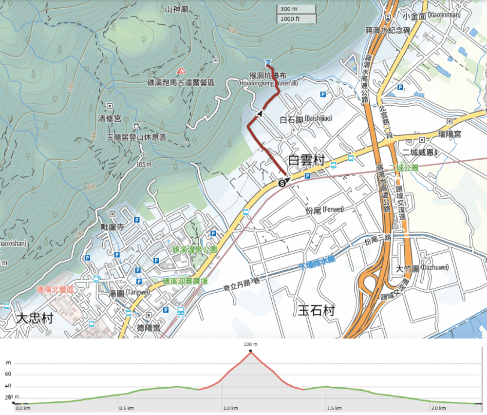
GPX file available here on Outdoor Active. (Account needed, but the free one works just fine.)
If you enjoy what I write and would like to help me pay for the cost of running this site or train tickets to the next trailhead, then feel free to throw a few dollars my way. You can find me on either PayPal or Buy Me a Coffee.
